Urban India Atlas
Urban India Atlas
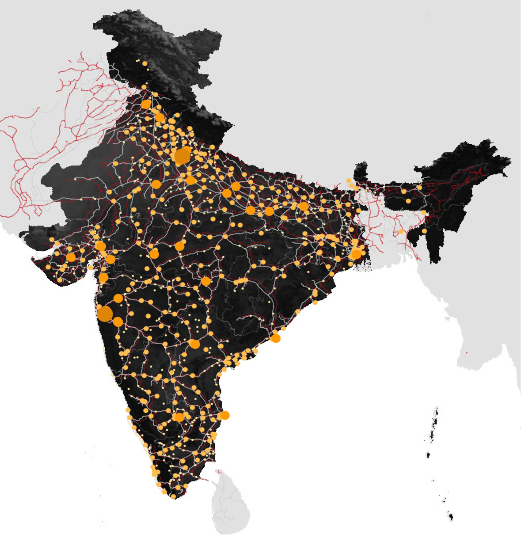
The Urban India Atlas project is a long-term critical assessment of emergent patterns of urban growth in India today. The investigation applies a range of spatial analysis techniques to better understand the logic (or lack thereof) behind urban, regional, and national development, and arrive at conclusions regarding future patterns of growth.
The study is unique in its focus on India’s large and medium- sized cities, in addition to the country’s megacities. A significant proportion of future urban growth will occur in what are typically defined as Tier II, Tier III, and Tier IV cities. Tier II cities are understood as rapidly expanding metropolitan centers with an average population of roughly 3 million residents, such as Jaipur and Lucknow. Tier III cities are defined as metropolitan areas with around 1.5 million residents, such as Asansol and Jamshedpur. Finally, Tier IV cities are characterized by a population of less than 1 million and include cities such as Bhubaneswar and Mysore.
In a class of their own are India’s world-class new towns, of which 25 are planned; one such town is Lavasa, a 25,000-acre private city currently under construction near Pune. Although many of these cities are seemingly insignificant when compared alongside Mumbai, Delhi, or Kolkata, many Tier II, Tier III, and Tier IV cities are advancing rigorous development plans and stand to see significant population growth in the coming decades. Other small and medium- sized cities are struggling to establish clear growth strategies or attract new investment, and are in danger of being left behind. The Urban India Atlas will catalog and account for these emergent trends of urbanization, with particular attention given to rapidly growing medium-sized cities.
Kumbh Mela
Kumbh Mela

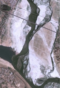
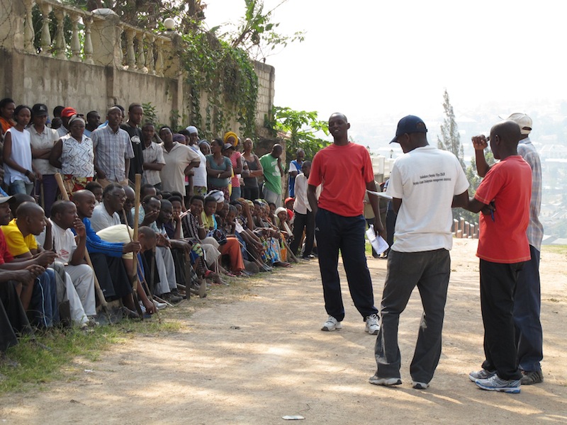
The Kumbh Mela is a Hindu religious festival that occurs every twelve years at the confluence of the Ganga and Yamuna Rivers in the city of Allahabad. Since its inception early in the first millennium CE, the Kumbh Mela has become the largest public gathering in the world; today it draws tens of millions of pilgrims over the course of a few weeks to bathe in the auspicious rivers. The Mela provides a forum for both individual and collective expressions of faith as pilgrims, religious teachers, and followers of monastic orders converge from all parts of India.
The Mela inspires interdisciplinary research in a number of complementary fields. Pilgrimage and religious studies, public health, design, communications, business, and infrastructure engineering converge at this festival, producing a complex atmosphere that can be understood through rigorous documentation and mapping, both on-site and in post-field processing. We consider the Kumbh Mela to be a case study, or prototype, for a concept we would like to call the pop-up mega-city. This spatial model can be extended to situations outside of religious pilgrimage: understanding the spatial, social, and logistical elements of the Kumbh Mela through interdisciplinary research will allow us to propose the deployment of these systems in a variety of places and situations, in particular camps for refugees of war and natural disasters.

The underlying structure of the Mela emerges in the creation of a temporary city to house its many pilgrims. This city is laid out on a grid, constructed and deconstructed within a matter of weeks; within the grid, multiple aspects of contemporary urbanism come to fruition, including spatial zoning, an electricity grid, food and water distribution, physical infrastructure construction, mass vaccinations, public gathering spaces, and nighttime social events. The ultimate goal of the pilgrims is to bathe at the convergence of the rivers: even this act is organized into a larger procession, where pilgrims are given specific times and opportunities to bathe based on their social status. When the festival is not in session, the ground on which the city sits is used for different forms of agriculture.
Visit Mapping the Kumbh Mela at the Harvard University South Asia Institute.
Support Urbanism and Citymaking at the GSD .
Environments for Walking and Cycling
Environments for Walking and Cycling
Initiatives to spur more walking and cycling have become increasingly prominent as one strategy communities are using to tackle the problems of greenhouse gas emissions, traffic congestion, resident quality of life, and public health concerns. As local governments face hard choices about which programs to fund, decision makers, planners, and residents all seek to understand if proposed policies to increase bicycling and walking—modes referred to as “active travel”—will actually work.
A series of my collaborative projects have examined how to create better environments for walking and cycling. Some projects have involved studying walking and cycling in particular places, most notably the Twin Cities Walking Study. Other work has synthesized the large literature in this area into guidelines for planners and designers. In other cases I have developed tools for evaluating environments and levels of walking and cycling. These tools included the Irvine Minnesota Inventory (IMI) for measuring built environments, the Pedestrian and Bicycling Survey (PABS) method for collecting population-level data, the Twin Cities Walking Survey, and the LEAN and NEAT GIS protocols for measuring built environments related to health.
2003-present
Selected Publications
2015 A. Forsyth and J.M. Oakes. Cycling, the Built Environment, and Health
: Results of a Midwestern Study. International Journal of Sustainable Transportation 15, 1: 49-58
2015 A. Forsyth. What is a Walkable Place? The Walkability Debate in Urban Design. Urban Design International 20, 4: 274-292.
2014 A. Forsyth and M. Oakes. Workplace Neighborhoods, Walking, Physical Activity, Weight Status, and Perceived Health
. Transportation Research Record 2452: 98-104.
2013 M.O. Hearst, J.R. Sirard, A. Forsyth, E.D. Parker, E.G. Klein, C.G. Green, L.A. Lytle. The Relationship of Area Deprivation, Individual-level SES and Walking Behavior Among Adults
. Transportation Research Part A 50: 149-157.
2012 A. Forsyth, K. Krizek, A. Agrawal, E. Stonebreaker. Reliability Testing of the PABS (Pedestrian and Bicycling Survey) Method. Journal of Physical Activity and Health 9, 5.
2011 M. Boarnet, A. Forsyth, K. Day, and J.M. Oakes. The Street Level Built Environment and Physical Activity And Walking: Results of a Predictive Validity Study for the Irvine Minnesota Inventory. Environment and Behavior 43, 6: 735-775.
2011 A. Forsyth and K. Krizek. Urban Design: Is there a Distinctive View from the Bicycle? Journal of Urban Design 16, 4: 531-549.
2010 A. Forsyth, J. Jacobson, and K. Thering. Six Assessments of the Same Places: Comparing Views of Urban Design. Journal of Urban Design 15, 1: 21-48.
2010 A. Forsyth and K. Krizek. Promoting Walking and Bicycling: Assessing the Evidence to Assist Planners. Built Environment: 36, 4: 429-446.
2009 A. Forsyth, K. Krizek, Daniel Rodriguez. Non-motorized Travel Research and Contemporary Planning Initiatives. Progress in Planning 71: 170-184.
Collaborators
Kevin Krizek at the University of Colorado and others
Urban Resilience in Situations of Chronic Conflict
Urban Resilience in Situations of Chronic Conflict
The sources and forms of social and political violence have been extensively examined, but the ways ordinary people and officials cope with chronic urban violence has received less attention. Using case studies of eight cities suffering from a history of violence, this project explores the phenomenon of coping with urban violence, which is termed resilience. This research report identifies the sets of conditions and practices that enhance an individual or a community’s capacity to act independently of armed actors.
The findings suggest that resilience appears at the interface of citizen and state action, and is strengthened through cooperation within and between communities and governing authorities. The security activities produced through citizen-state networks are most accountable and durable when the communities themselves, in a relationship of cooperative autonomy, direct them. Urban resilience also benefits from good urban planning, including promoting and investing in mixed land usage and building infrastructure that enables the free movement of people within and between all neighborhoods to promote security and livelihoods. The report also develops the idea of legitimate security as a way to address the vexing interactions of the state and communities in the provision of security and positive resilience. Legitimate security seeks to ensure democratic and participatory governance in the political, civil, and social sense. This research stresses that legitimate security fosters broad participation and initiatives from “below” with an increased focus on multi-sector partnerships to provide more effective, lasting, and accountable ways forward for cities seeking security.
Collaborator: John Tirman, executive director of MIT’s Center for International Studies
Sponsor: USAID’s Office of Conflict Management and Mitigation
Korean and East Asian Urban Research Program
Korean and East Asian Urban Research Program
Research focuses on urban settlement dynamics in evolving natural and regional contexts of Korea, China and Japan aimed towards identifying and explaining processes and arrangements that might be more optimal than others. Focus is also given to the physical characteristics of urban settlement patterns, involving planning, management and design associated with land use and environmental issues, buildings, landscapes, and supporting infrastructure, as well as on social, economic, and environmental factors which bear on the physical environment. Data is being gathered and a knowledge base formed extending to:
1. National and regional patterns of urban settlement at different scales, including spatial and inter-temporal changes, rank-size distributions and considerations of locational advantages and disadvantages.
2. Formal-functional properties of urban settlement at different scales. These will include densities, characteristics of transportation, regimes, land uses and mixes of uses, morphological consideration of building concentrations, open space and urban service provision, along with apparent economies of scale and scope.
3. Rights, roles and responsibilities, and underlying processes of involvement by the public sector, private sector and civil society in shaping settlements, including differences among various national settings in these regards.
4. Metrics of sustainability, flexibility, and resilience. Periodic reports and other publications will be published during the course of the research, and results will be incorporated into on-going coursework and teaching at the Graduate School of Design, Harvard University.
Seoul, South Korea
2012-2017
Sponsored by the Eugene Corporation.
MudWorks
MudWorks

MudWorks is a design-build installation and exhibition demonstrating the potential of building with raw earth. Organized by the 2012 Loeb Fellows and led by Anna Heringer and rammed earth specialist Martin Rauch, the design and construction has involved students, faculty, and the public. The companion exhibition within Gund Hall describes eleven exemplary projects from five continents. Three techniques of earth construction were tested and are demonstrated here: rammed earth construction, formwork, and plaster lime. MudWorks demonstrates earth as a material central to architectural discourse for reclaiming cultural identity, providing tactile and human-scaled environments, and producing plentiful labor opportunities.
Better Suburbs
Better Suburbs
Beyond the core of every large urban area is a band of development called suburbs. For some decades I have been examining how to make suburban development better. My first book on suburbs, Constructing Suburbs (1999, Routledge/Gordon and Breach), looked at competing approaches evident in planning for suburban development in Australia in the 1990s. Its focus was on how issues of sustainability and urban growth were articulated and how tradeoffs were made about social and ecological goals. My next book, Reforming Suburbia (2005, University of California), used multiple methods to reassess three of the largest and most successful of the U.S new towns (“planned communities”) of the 1960s and 1970s planned as intentional alternatives to problems urban sprawl–social, aesthetic, economic, and environmental. These developments used many of the techniques currently evident in smart growth and new urbanist developments. A series of articles with Katherine Crewe extended this work to look at international examples of comprehensively planned neighborhoods, towns, and villages, designed to deal with the social, ecological, technological, and aesthetic challenges of urban growth. Current work focuses on the challenges of suburbanization globally as suburbs are a key frontier in the quest for longer term sustainability at the global level with important implications for human and ecological health.
1999-present
Related Links
http://annforsyth.net/research/
http://research.gsd.harvard.edu/new-towns/
Selected Publications
2016 P. Rowe, A. Forsyth, and Har Ye Kan. China’s Urban Communities
: Concepts, Contexts, and Well-being. Berlin: Birkhäuser.
2016 A. Forsyth, C. Brennan, N. Escobedo, and M. Scott. Revitalizing Places: Improving Housing and Neighborhoods from Block to Metropolis/Revitalizando Ciudades: Mejorando Viviendas y Barrios desde la Cuadra a la Metrópolis. Cambridge, MA: Harvard Graduate School of Design. In English
and Spanish
.
2014 A. Forsyth. Global Suburbia
and the Transition Century. Urban Design International, 19. 4: 259-273.
2014 A. Forsyth. Alternative Forms of the High Technology District
: Corridors, Clumps, Cores, Campuses, Subdivisions, and Sites. Environment and Planning C 32, 5: 809-823.
2013 A. Forsyth. Suburbs in Global Context:
the Challenges of Continued Growth and Retrofitting. Planning Theory and Practice 14, 3: 403-406.
2012 A. Forsyth. Defining Suburbs
. Journal of Planning Literature 27, 3: 270-281.
2011 K. Crewe and A. Forsyth. Compactness and Connection in Environmental Design: Insights from Ecoburbs and Ecocities for Design with Nature. Environment and Planning B 38, 2: 267-288.
2010 A. Forsyth and K. Crewe. Suburban Technopoles as Places: The International Campus-Garden-Suburb Style. Urban Design International 15, 3: 165-182.
2009 A. Forsyth and K. Crewe. New Visions for Suburbia: Reassessing Aesthetics and Place-making in Modernism, Imageability, and New Urbanism. Journal of Urban Design 14, 4: 415-438. [Abstract]
2005 A. Forsyth. Reforming Suburbia: The Planned Communities of Irvine, Columbia, and The Woodlands. Berkeley: University of California Press
Collaborators
Katherine Crewe, Arizona State University
Assessing the relationship between urban design and urban climate in selected Bronx neighborhoods
Assessing the relationship between urban design and urban climate in selected Bronx neighborhoods
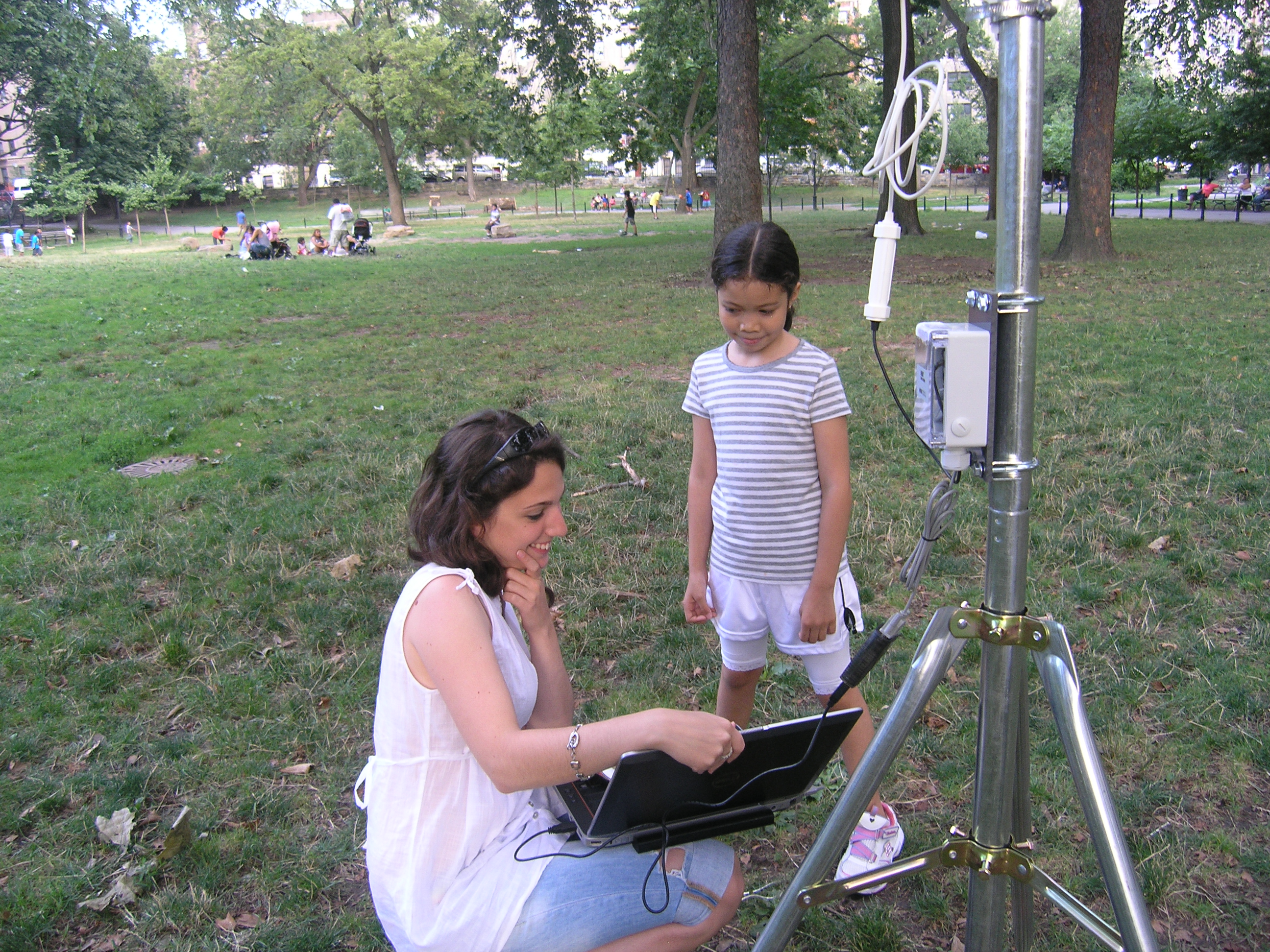
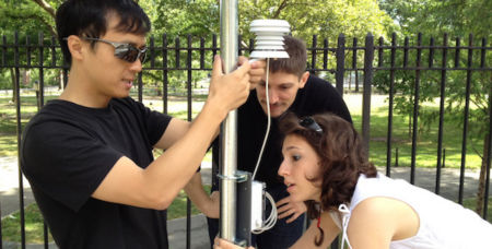
Research assessing the relationship between urban design features and urban climate in densely populated neighborhoods is becoming increasingly important as cities continue to grow and climate change occurs. In the summer of 2012, students from the Advanced Research Seminar on Urban Climate and local, community volunteers studied the effects of green infrastructure (parks) on the urban heat island effect in the two Bronx neighborhoods of Saint James Park in Community District 207 and Echo Park in Community District 205. Using temperature sensors and examining urban features and the built environment, the team collected information to begin developing a dataset useful for modeling the urban environment.
In addition to the summer field research, the advanced research seminar did an extensive spatial and demographic analysis of vulnerability to climate-health impacts, along with modeling outdoor thermal comfort in relationship to the built environment in these neighborhoods.
The results of these efforts will be used to understand the effectiveness of heat island mitigation methods used by cities and suggested by US. Environmental Protection Agency, which include increasing surface permeability, creating more vegetative cover, using cool reflective materials, installing green roofs and cool roofs on buildings. Once the effectiveness of different mitigation techniques is know, the best methods can be used to lessen the negative health consequences arising from heat in cities.
Research Assistant:
Naz Beykan (MDes ’12)
Sponsored by a Robert Wood Johnson Foundation Seed Grant from Harvard Center for Population and Development Studies
Extreme Urbanism I: Reimagining Mumbai’s Back Bay
Extreme Urbanism I: Reimagining Mumbai’s Back Bay

The Back Bay of Mumbai—underdeveloped, sandwiched between high rise office and residential blocks, historic buildings, a fishing village and slums—is perhaps the most contested locality in the city. It’s a place where the “Static City” or planned urban environment collides with the “Kinetic City “ of temporary materials and constant flux. Beginning in 2011, Rahul Mehrotra, Chair of Urban Planning and Design at the Graduate School of Design, has undertaken the challenge of honoring this duality while imagining a future for the site in the Extreme Urbanism Studio. The multiyear project incorporates an annual visit to Mumbai and takes advantage of the expertise and creativity of Loeb Fellows as mentors and advisors for students drawn from the GSD, Harvard Business School, and the Kennedy School.
Collaborators
Harvard Kennedy School of Government, Harvard Business School, Real Estate Academic Initiative at Harvard University, and the Loeb Fellowship at the Graduate School of Design.
Extreme Urbanism is part of Reconceptualizing the Urban, a four year investigation of urban studies funded by the Mellon Foundation. Learn more at the Harvard Mellon Initiative .
South America Project
South America Project
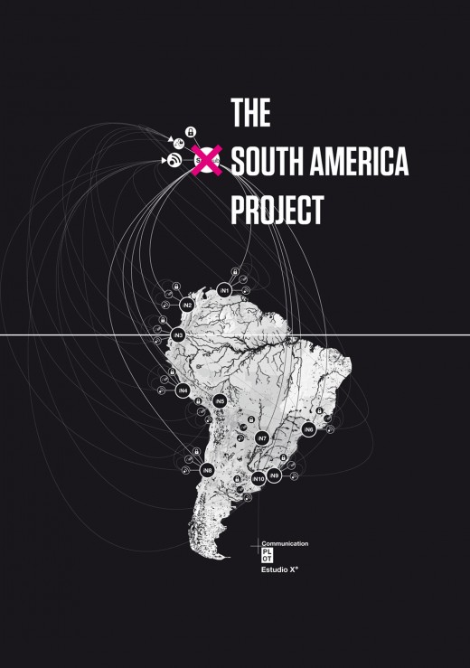
The South America Project (SAP) is a trans-continental applied research network that proactively endorses the role of design within rapidly transforming geographies of the South American continent. The project brings together a broad host of academic institutions, scholars and designers from diverse fields, building a trans-disciplinary platform for action in the South American regional integration movement. Through the lenses of architecture, landscape architecture and urbanism, SAP affiliates propose more comprehensive models of urbanization for South America.
The South American hinterland is currently undergoing unprecedented spatial transformations, particularly through fast-paced modes of resource extraction and regional integration at a continental scale. Regional highways, energy grids, fluvial corridors, and telecommunications networks are reconstructing the South American landscape. Too often this reconstruction is narrowly defined by utilitarian resource extraction and the deployment of mono-functional infrastructure. SAP focuses on how a spatial synthesis best afforded by design can provide alternative physical and experiential identities to current modes of spatial transformation.
SAP undertakes its research through diverse mechanisms, including design and research studios, research seminars, digital and analog publications, conferences, seminars, lectures, round table discussions and documentary films. The network´s output is shared with diverse constituencies involved in continental planning, in an attempt to allow design to partake in decision making processes and exert a positive impact in the South American territories. Launched by Felipe Correa and Ana María Durán Calisto, the SAP is supported by of the Department of Urban Planning and Design at the Harvard Graduate School of Design, the David Rockefeller Center for Latin American Studies and the Loeb Fellowship.
Selected publications
Correa, Felipe. “Water and the Urban Project,” Globalized Water. Edited by Graciela Chneier-Madanes. New York: Springer, 2012.
“SAP. Continuamos con nuestra cobertura de The South America Project (SAP): Hinterland Urbanisms, presentando información sobre todas las investigaciones que se estan llegando a cabo.” PLOT. 7, 2012.
Principal Investigator
Felipe Correa
Collaborators
Víctor Muñoz Sanz (MAUD ’11), PhD candidate, School of Architecture of Madrid
Ana María Durán Calisto (Loeb ’11), School of Architecture, Design and Arts of Universidad Católica del Ecuador
Sponsor
The Santo Domingo Endowment and the Lemann Endowment of the David Rockefeller Center for Latin American Studies at Harvard University, with additional support from the GSD Department of Urban Planning and Design and the Loeb Fellowship.