SURVEY: Multi-Modal Readings Of Bandelier National Monument’s Geologic And Spatial Relations
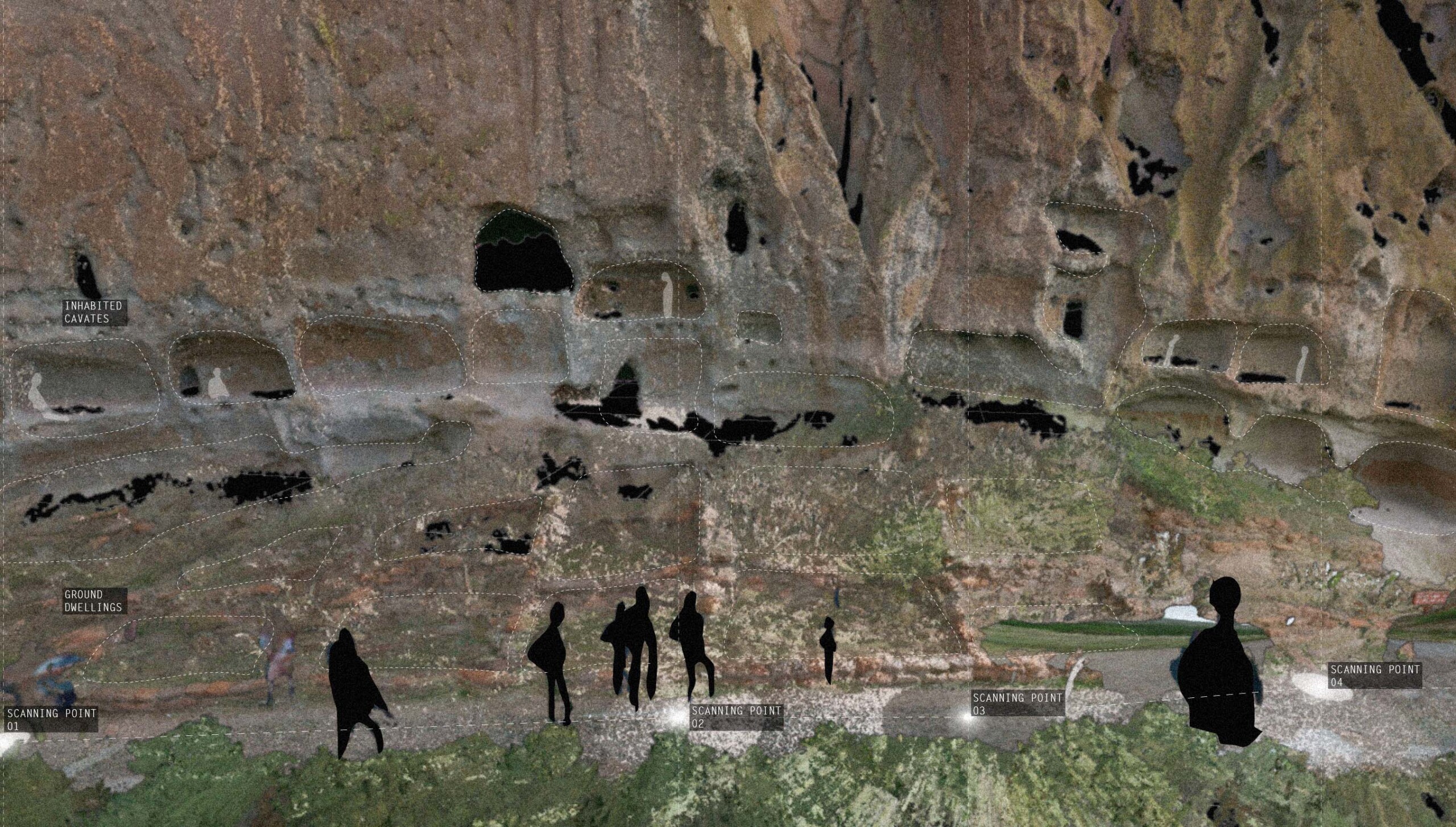
Bandelier National Monument preserves the homes and territory of the Ancestral Puebloans who inhabited the Frijoles Canyon fifty miles west of Santa Fe, New Mexico between 1150 and 1600 AD. The site contains a unique assembly of Ancestral Puebloan homes and kivas carved into Bandelier’s porous volcanic tuff cliffs. Supported by Harvard GSD’s Penny White Project Fund and Cornell AAP’s Robert James Eidlitz Travel Fellowship, the team documented and analyzed Bandelier National Monument in Summer 2023 on and off-site as a case study of intimate human-landscape interaction. SURVEY’s result is a first-of-its-kind digital model paired with experimental photography that preserves these fragile, ancient marvels to serve as an immortal primary source for archaeologists, historians, scientists, or artists. On a broader theme, the exhibition encourages the multi-modal documentation of fragile sites such as Bandelier National Monument at a time when it, and other critical landscapes around the globe, are at risk of accelerated deterioration due to unprecedented factors related to climate change. The exhibition aims to catalyze a dialogue in the GSD community about the role of qualitative and quantitative reality capture technology in landscape conservation and preservation.
Background
Geologic structure and socio-geography intertwine within Bandelier National Monument to enable a collapse of human and geologic time scales and spatial scales. The Bandelier cliffside was formed by a series of gigantic volcanic ash flows between 1.4 and 1.1 million years ago. The eruptions blanketed the area in a 300-ft thick carpet of ash, which consolidated into a very soft rock called tuff. Air bubbles formed within the ash flow as it deposited, which gives the sheer cliffs their porous appearance. These thousands of pockets are called “cavates,” which Ancestral Puebloans further hollowed out as a framework for their dwellings.
Methods
Employing LiDAR scanning, analog photography, analytical drawing, and cartography, SURVEY interrogates the landscape’s precise geologic and material conditions that prompted human habitation in an otherwise hostile terrain. The multi-modal survey of Bandelier National Monument serves two purposes within this theme: 1) capturing both quantitative and qualitative site data 2) contributing new digital recording techniques to existing archaeological and ethnographic surveys of the site. The team employed Leica Geosystems’ BLK360, a high-precision 3D laser scanner in conjunction with Lomography’s experimental analog film cameras to document the ruin system. The laser scanning equipment captured billions of precise three-dimensional data points, while experimental photography breathed spirit, atmosphere, and texture into the dataset. Through this, the team identified climate vulnerabilities, explored what gives this delicate site cultural value today, and emphasized the importance of devoting technological resources to uphold it.
Acknowledgments
Thank you.
Thank you to the family of Penny White who dedicated resources for future students to explore and learn about our world. Thank you, Harvard University Graduate School of Design, Frances Loeb Library, our advisors Dan D’Oca and Tao DuFour for your support of our curiosities and providing the resources for us to pursue them.
Thank you to Ranger Steve and fellow Park Rangers at the Bandelier National Monument for your warmth, knowledge, and accommodation of our requests to laser scan, charge equipment, and ask questions. Also, thank you to the Bandelier visitors for your patience, encouragement, and exciting conversations as we met along the trail.
Thank you to Chris Curley, Chris Wilkes, and the Leica GeoSystems team for your kindness, trust, and generosity in providing us with the Leica BLK360 laser scanner and Register360 software which made the LiDAR documentation possible. We are eternally grateful for your technical assistance in retrieving the data from our scans after our trip, and for having us as early-access users of your new Reality Cloud Studio platform. We are also thankful for Elias Kruse Logan and Andy Fontana who kindly connected us to Chris and Chris so quickly.
Thank you to Kayla Lew, Elena Loffreno, and the Lomography team for your openness and graciousness in providing analogue cameras and experimental films to allow us to creatively photograph the atmosphere of the cavates. “Don’t think, just shoot!”
Thank you Lance Li for entrusting us with your FLIR C3 as we explore the Ancient Puebloan caves.
Thank you to Elizabeth Ehrnt and the Georgia O’Keeffe Museum for accommodating our visit and sharing the stories and artifacts of Ms. O’Keeffe with us.
Thank you Porus D. Olpadwala for your warmth, generosity, wisdom, and delicious home cooking.
And thank you to Joseph Kennedy Jr. and Sonny Meng Qi Xu for your labor (carrying equipment and supplies, driving, navigating, battery charge runs, waiting, crowd control, etc.), patience, humor, courage, and emotional support. We couldn’t have done this without you. Please continue to wear sunscreen daily.

Looking for older event archives? Please contact Loeb Library or visit our YouTube channel.