Miami Beach Baywalk
Chris Merritt (MLA I ’17)
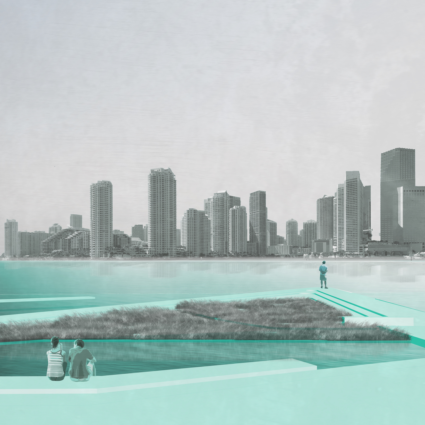
The Miami Beach Baywalk will serve as an infrastructure for storm surge and stormwater quality while functioning as a new public space for Miami Beach. Sea level rise projections indicate the Bayside is the most vulnerable on Miami Beach. In addition, as this area has the lowest elevation, the city’s stormwater naturally drains and is pumped to the Bay. Recently, the City of Miami Beach has installed pumps along the Bay to handle the pressures of large volumes of stormwater runoff. The new Baywalk is designed to alleviate stormwater quality issues while enhancing the quality of the public realm. The Baywalk will serve as a continuous, connected, and visible system of plazas and walkways that return the Bay as a destination to the city.
Background
The emergent topic of urban adaptation to the effects of climate change is among the more pressing areas for those engaged in the design of the built environment. Among the more extreme cases in this regard is the present status and uncertain future of South Florida’s coastal communities. In Miami Beach, the low-lying coastal conditions and singular cultural heritage resist the types of massive civil engineering projects that have recently been proposed for other major international cities. As Miami’s coastal barrier islands form one of the most recognizable and singularly valuable cultural landscapes in the world, the conditions in Miami Beach reveal the potential for ecological and infrastructural strategies to act as alternatives to large single purpose engineering solutions. Today, the structuring elements of urban form in Miami Beach are quickly becoming the pumps, seawalls, road elevations, artificial dunes, and sacrificial floors that are deployed in response to rising sea levels and increased storm events. How can designers act and what is the role of the landscape architect in this urgency for urban adaptation?
Miami Beach is a construction. It was drained, defoliated and developed through the promotion of its climate; perfect temperatures, ideal beaches, seamless horizons, warm water, and unencumbered escape. The porous oolitic-limestone that underlies Miami Beach makes the city particularly vulnerable to sea level rise as seawalls are simply ineffective, and multiple pumps are only temporary measures that help municipalities cope, but not adapt. With the pending dimensions of sea level rise, water has become a threat, as it is generally accepted that Miami Beach will be subject to rising waters and flooding – not to mention potential devastation from incoming and worsening storm tracks. With the conservative estimate of a 2ft rise in our oceans by 2060, Miami Beach will be underwater and Miami shorelines will recede up to 2,000 ft. (National Climate Assessment Data). While hard infrastructure, raising roads, and proliferating pumps are managing the issues and allowing the city to cope, the prospects and opportunities of future scenarios remain unknown.
Urban adaptation to ambiguous sea levels is creating a new form of public space, and the application of resilience as a measure of success must respond to and address these new public parameters. Given the reliance of South Florida’s economy and identity upon the specific landscape conditions of Miami Beach, this project proposes to use green infrastructure, landscape ecology, and cultural heritage as potential responses to the looming threats associated with sea level rise.
Project Description
A cross section through Miami Beach reveals a slight slope from the nourished ocean-side beaches and Ocean Drive down to the Bay. As the commercial back-bone of the city and lowest in elevation, this area is Miami Beach’s most vulnerable, and current target for intervention by the City. The natural topography and recently installed pump infrastructure carries the island’s stormwater to the Bayside where it is pumped back to the Bay. Through the aggregation of private condo development common to Miami Beach, a wall has been created that separates the city from the Bay with limited access. The proposed Baywalk project outcomes are threefold: 1) introduce an infrastructure for managing stormwater quality, 2) mitigate effects from storm surge, and 3) renew the public realm with access and visibility to an ecological and culturally vibrant landscape.

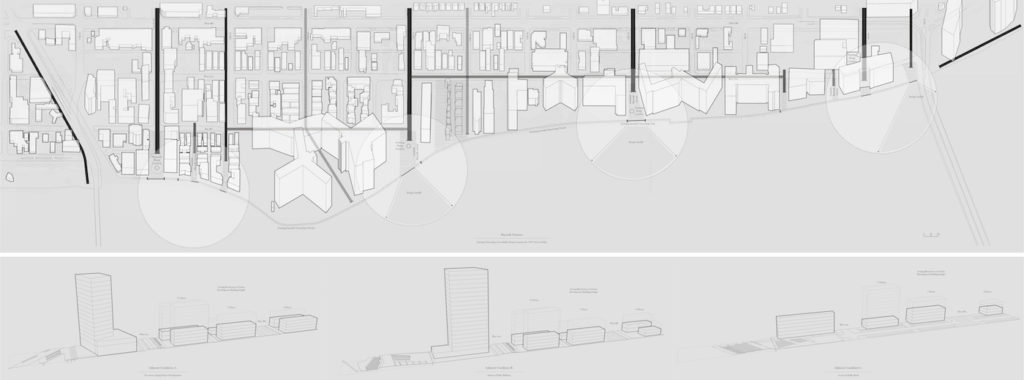
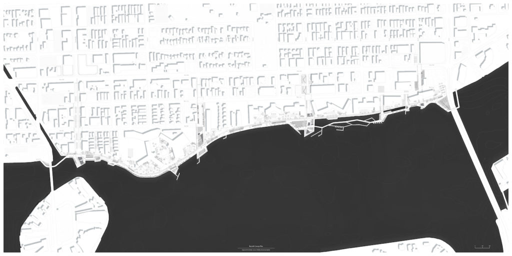
The proposed new Baywalk is a continuous linear public space connecting Miami’s South Pointe Park via the 5th Street Causeway to Maurice Gibb Park to the north. The Baywalk also reaches back into the city, literally and figuratively, utilizing City owned parcels and streetscape improvements to provide better access and visibility while managing stormwater before it reaches the Bay. Previously, private condos along the Bayside have fragmented the Baywalk – leaving no connections between each development. In addition, with the introduction of new pump infrastructure at the Bay, an opportunity exists to leverage this system for a model of urban adaptation to sea level rise.
The framework of the Baywalk starts with recognizing an opportunity for increased public space exists at each of the existing and proposed pump station locations. These locations are utilized to bring stormwater runoff from the city through a system of separation, filtration, and aeration before releasing water into the Bay. The Baywalk is not just a utility; it also enhances the public realm experience. The pump station locations are transformed into large plazas for gathering that are distributed evenly and provide a unique experience along the Baywalk. This new public space exists at the terminus of Lincoln Road, 14th Street, 10th Street, and 6th Street. The plazas are linked together through a linear Baywalk that removes the existing divide between private and public.
The condos along the Bay in Miami Beach sit on a podium filled with parking that creates a wall along the fragmented Baywalk. In some cases, the buildings have a simple retaining wall separating the Baywalk from the private terraces of the condos. This condition creates a separation that reveals the sharp contrast between the private condos and the minimal Baywalk – “the haves and the have-nots.” The proposed Baywalk joins the two spaces creating a seamless public realm that transitions from building to water through a series of terraces, slopes, walls, and landscape elements.
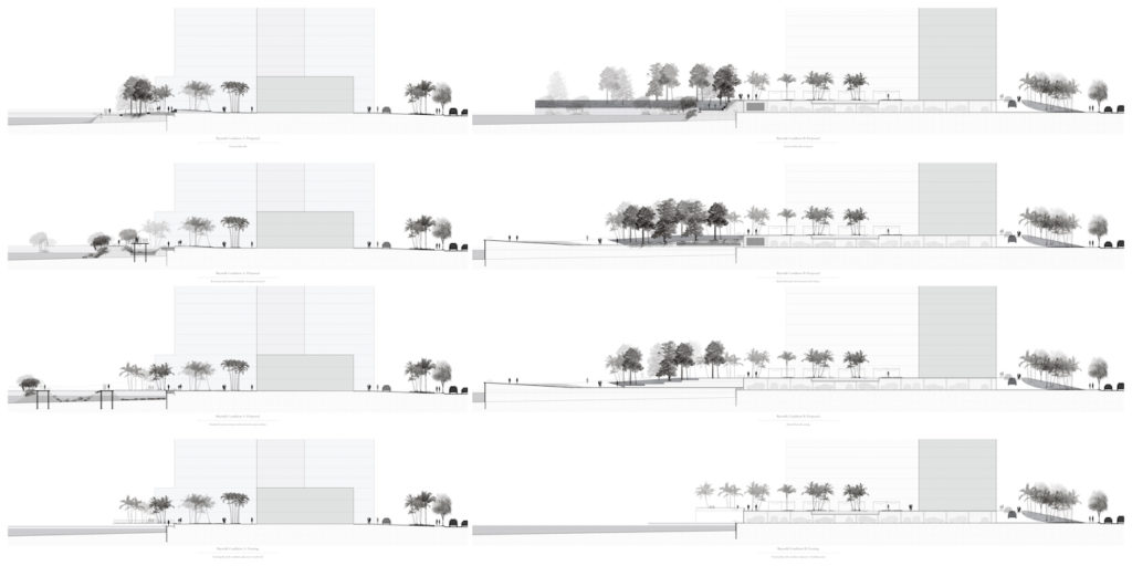
Miami Beach is a place for people watching and sun bathing; and for recreation and relaxation. The currently underutilized Baywalk is transformed into a public promenade where one can see and be seen. Utilizing the necessity for elevation change, varied experiences are created and rooms are carved along the Baywalk for smaller gathering and intimacy. With retail, dining, and entertainment, the Baywalk serves as an extension of Lincoln Road at the Lincoln Road plaza. And, by removing the divide between public and private and offering new access, the Baywalk serves locals in Flamingo Park. The extension of the Baywalk back into the city fabric offers visibility and a physical connection that ensures the Baywalk is built for everyone.
South Florida attracts residents and tourists alike for its subtropical climate. Combinations of unique species of flora and fauna are found in this geography that cannot exist elsewhere. In addition, the Bayside of Miami Beach was historically home to thriving marine habitats before the introduction of anthropogenic pollution and destruction. Therefore, the Baywalk is designed to accommodate habitat development for its ecological function and cultural significance. At each of the stormwater management plazas, vegetation is selected for its utilitarian function. In other areas, a cultural abstraction is utilized to create a “marine museum” or “ecological museum” that serve as a cabinet of curiosities along the Baywalk. Vegetation zones include pineland and hammock planters, temperate and tropical assembly gardens, a beach with an artificial dune, and linear mangrove habitats. The “marine museum” includes boardwalks through sheltered pools that enable stable habitats of seagrass, coral, sponges, and wetlands.
Through proactive measure Miami Beach can respond to the threats of sea level rise with opportunistic infrastructural intervention that also enhances the public realm. In a challenging political climate and market with increasing private interest, the City has to be strategic about investment in the longevity and quality of Miami Beach for the public good. A new Baywalk that manages stormwater quality, protects against storm surge, and enhances the public realm is a boon for visitors and residents of Miami Beach alike.