Droughts, floods, food shortages, species extinction—the impacts of climate change are physically tangible. Yet, the terms and data used to describe these predicted impacts often seem abstract. Richer visualization techniques offer great promise to communicate the consequences of climate change and thereby promote the adoption of strategies to preempt these effects. This semester at the Harvard Graduate School of Design (GSD), master of landscape architecture (MLA) students are exploring two such innovative modeling approaches: a framework for understanding spatial impacts of climate strategies over time, and a modern sand table that supports real-time simulations.
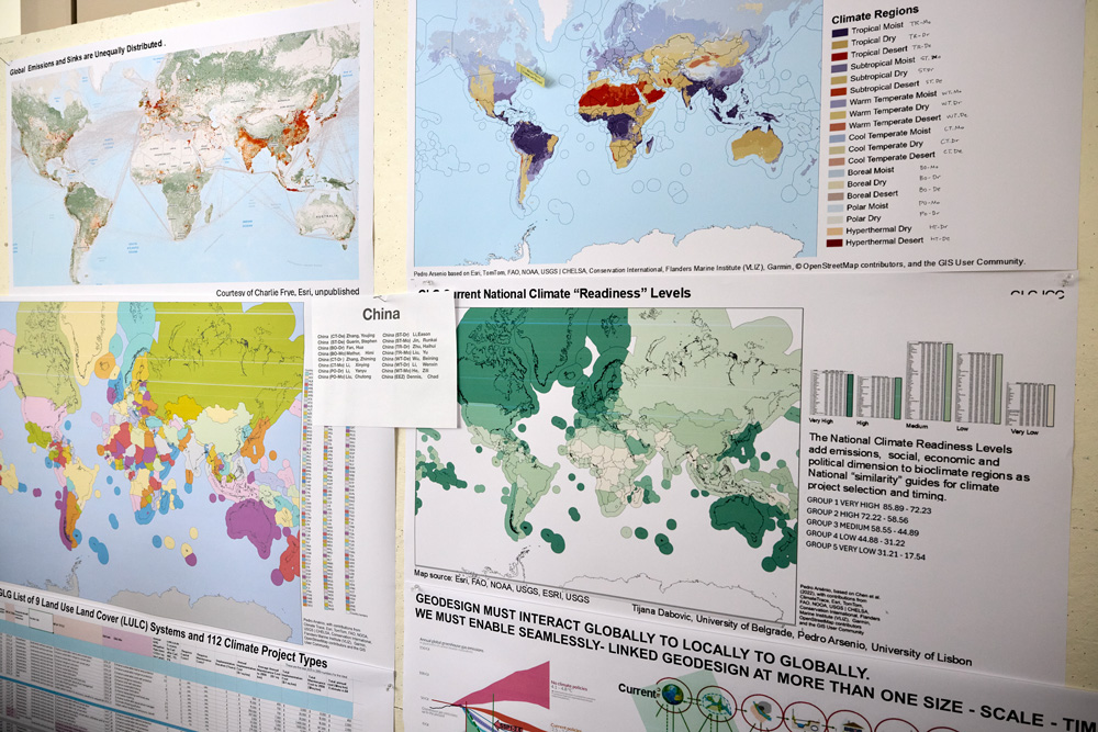
Since the 1960s, Carl Steinitz—Alexander and Victoria Wiley Professor of Landscape Architecture and Planning Emeritus—has been contemplating land-use change as a designed process. As part of the Harvard Laboratory for Computer Graphics and Spatial Analysis, Steinitz began using geographical information system (GIS) maps to evaluate the impacts on a given area of variables such as population growth and migration, financial influx, and environmental conservation. In the ensuing years, Steinitz developed a framework for “geodesign,” a term coined to describe design in a space linked to a geographic coordinate system with its accompanying specificities. Today the International Geodesign Collaboration (IGC), which Steinitz helped found, defines geodesign as “a collaborative approach [that] uses GIS-based analytic and design tools to explore alternative future scenarios in response to global problems.” When first exploring this problem five decades ago, Steinitz initiated his geodesign work with a two-square-mile geographical region; recently, he expanded this scope to the global scale.
In 2022, in conjunction with the company Esri—a global leader in GIS software, location intelligence, and digital mapping, cofounded by Jack Dangermond (MLA ’69)—Steinitz and additional collaborators began work on the ICG Global to Local to Global (GLG) Climate Mitigation Project, building the technology to facilitate geodesign for the purpose of climate change mitigation.1 Steinitz introduced the project to MLA Core IV students (those engaged in their final studio of the core sequence), characterizing mitigation as “a multi-jurisdiction, multi-scalar geodesign problem. Climate change,” he explained, “is a global existential phenomenon, and all nations must act in collaboration if climate mitigation is to succeed. Guided by climate science, this requires looking and thinking ahead in time, globally to locally to globally, and planning now to act now for the future of everyone.”
While multinational agreement and a global oversight of planning, negotiation, and implementation does not yet exist, Steinitz and colleagues view the GLG Climate Mitigation Project, a protocol to facilitate this process, as necessary infrastructure for future climate action. Building from a geodesign framework published in 2012, Steinitz has created tools to identify mitigation strategies to optimize impact by considering the date of initiation (for example, 2025, 2050, or 2080), execution and maintenance costs, alterations in climate (temperature and aridity), and additional variables across a span of decades. Focusing on changes in land use, the goal is to lower carbon emissions below zero, ideally (if perhaps improbably) returning atmospheric measurements to pre-Industrial Revolution levels. In short, the GLG Climate Mitigation Project offers a preview of, and guidance on how, mitigation-related decisions can affect our future.
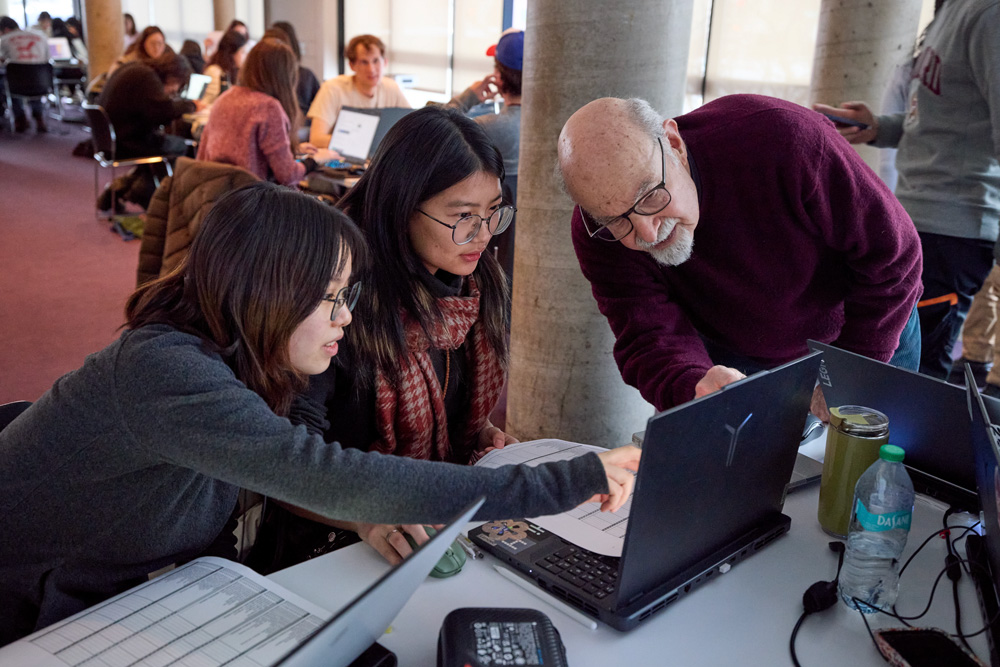
Following his explanation of the project, Steinitz walked the MLA Core IV students through a tutorial on how to use it. This exercise served a double purpose, providing a test run for the tools themselves while preparing students for their upcoming semester-long studio “The Near Future City,” focused on Boston’s Charlestown neighborhood. Lorena Bello Gómez, GSD design critic in landscape architecture and lead instructor of the studio, sees the GLG Climate Mitigation Project as a climate action framework students can use to determine suitable mitigation strategies for the studio’s site. These include strategies such as enhanced wetland restoration, neighborhood energy retrofits, infrastructural recalibration, urban canopy growth, and sustainable wastewater management.
Charlestown sits within a warming climatic region that, in years to come, will face increasing challenges around already-problematic issues of inland flooding, salt-water inundation, and heat island effect. Highlighting why climatic shifts matter, Steinitz asked students about appropriate trees to plant at this location today. “Where are you going to look [for precedents]—Charlestown or South Carolina?” Considering that the latter approximates Charlestown’s expected climatic region in 2050, “I’d look to South Carolina if I were you,” Steinitz declared, “especially if the trees take thirty years to grow,” as many species do. This point, while seemingly simple, underscores an important reality: today’s designs must take future conditions and long-term repercussions into account.
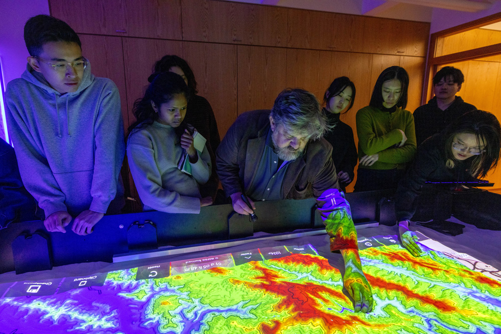
For the students, then, the GLG Climate Mitigation Project offers mitigation strategies for Boston’s climatic region that can be adapted for maximum impact in Charlestown. Once students have a particular strategy in mind, they can explore a different visualization technique—the Simtable. Invented by Stephen Guerin, affiliated with Harvard’s Visualization Research and Teaching Laboratory, the Simtable is a high-tech sand table that uses GIS data and computational modeling to explore complex phenomena, such as wildfires or chemical plumes, that involve people, places, and things interacting over time.
To demonstrate the Simtable’s interactive and projective capabilities, Guerin projected a topographic map of a fire-threatened Los Angeles region onto the sand. He asked the students to shape the sand by hand, following the map’s contours, building mountains and excavating valleys. Onto this modeled surface Guerin then projected satellite imagery of the area. Setting parameters such as time and weather conditions, he began testing scenarios for the fire’s progression and containment, using a laser pointer to select and implement different tactics. For example, how does bulldozing a trench from point A to point B impact the fire’s spread? What about sending resources to points C and D simultaneously? Or staggering them, while designating certain routes for human evacuation? The interactive simulations offer immediate feedback with minimal effort, facilitating a rapid iterative process for exploring, adjusting, and assessing interventions. Guerin’s ingenious tool has been employed numerous times during real-life emergencies, including the Los Angeles fires in January 2025.
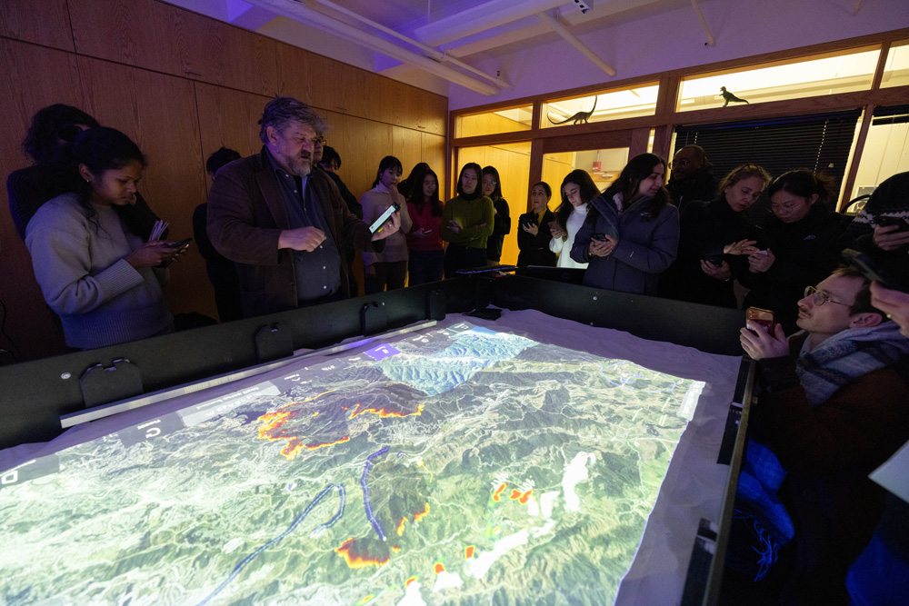
For GSD landscape architecture faculty, the Simtable offers phenomenal possibilities to inform design. Bello envisions the table as a tool that could allow architects to “move back and forth between design and performance, exploring parameters in a more fluid iterative process” than afforded by conventional physical modeling techniques, which are notoriously labor and time intensive. Furthermore, Simtable’s interactive nature could enhance community participation in climate adaptation and mitigation planning, the success of which often relies on robust social engagement. As Bello notes, instead of showing data on a stationary screen, “you are projecting data onto [a tangible representation of] the territory, empowering people to construct that territory, which empathetically puts them in mind to act.”
Yet, before the Simtable can be employed by architects, experimentation is required. “We need to translate this tool into our field,” Bello says. “How might we use the Simtable, and how can it be used in landscape design? That is what we want to test.” And this is where the MLA Core IV students enter the picture. Just as the students tested Steinitz and team’s tools, Core IV faculty will continue to work with Guerin this semester to introduce the Simtable in early stages of architectural investigations, from site selection through design performance.
Of course, visualizing data is only part of the work undertaken by designers. Each site comes with its own history and current residents, who have with their own aspirations. Thus, in preparation for the Core IV studio, the students met with several people with strong ties to Charlestown. In addition to Steinitz’s and Guerin’s workshops, MLA students heard from experts such as Alex Krieger (GSD professor in practice of urban design, emeritus), who shared insights about Charlestown’s physical evolution; officials from the Boston Water and Sewer Commission, the Environmental Protection Agency, and other institutions, who discussed current plans for the neighborhood; and nonprofit leaders from organizations such as Boston Harbor Now, who work to address community needs. Students must consider all thisinformation and more as they assess and design for their urban site. The innovative methodologies embodied by the GLG Climate Mitigate Project and the Simtable will further support the students’ design efforts, now and in a future marked by inevitable change and environmental crisis.
- GLG Climate Mitigation Project collaborators include Stephen Ervin (Harvard GSD), Pedro Aresino (University of Lisbon), Tijana Dabović (University of Belgrade), Michele Campagna (University of Calgary), and Alex Killing (Yale Center for Biodiversity) among others. ↩︎