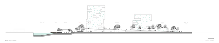
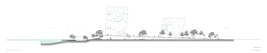
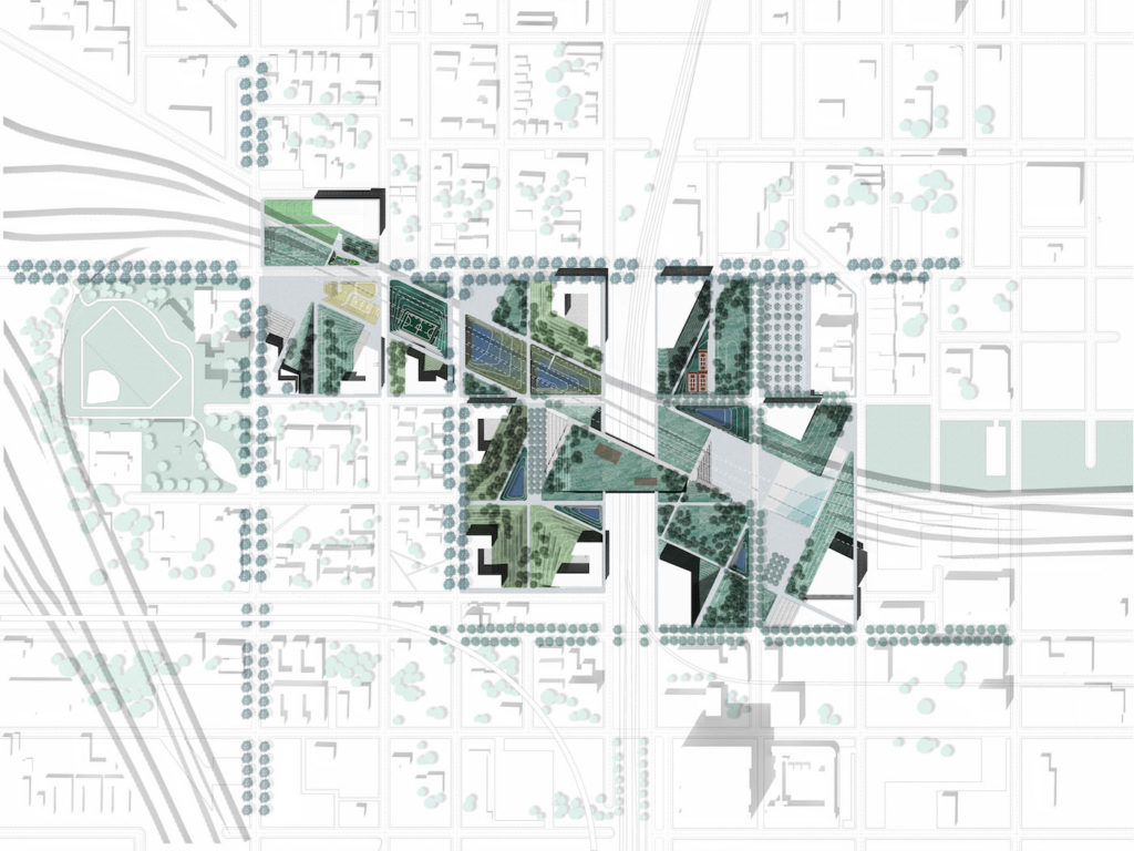
Common Grounds: An Alternative Way of Living
Common Grounds: An Alternative Way of Living
Parawee Wachirabuntoon (MLA I ’19) and Charles Smith (MLAUD ’19)
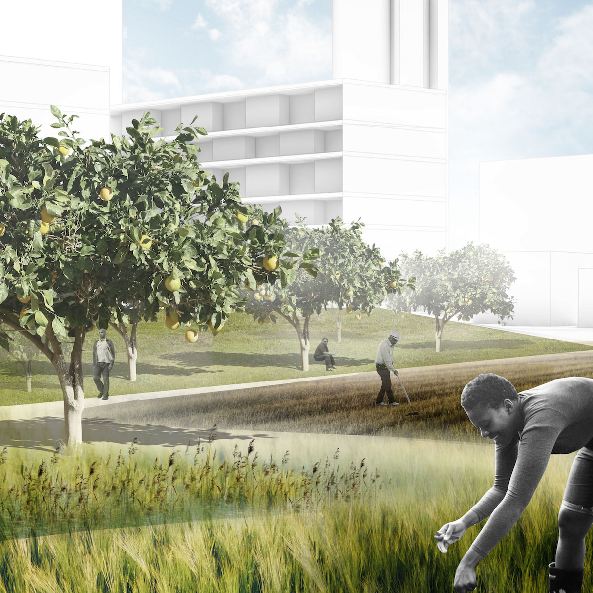
This project looks to create a collective and resilient living environment in a historically segregated and underserved community. Looking at this new development from a landscape perspective first we looked into the ideals of creating social interaction and resiliency through the proximity and adjacencies of the designed elements as they work together to foster a new way to live. We then analyzed land vacancy and land banking in the Overtown neighborhood as well as did a hydrological study to see how sea level rises, salt water intrusion, and king tides affect the neighborhood. From this analysis we found that many developers are buying large parcels of land in the area, this is due to the fact that Overtown is located on some of the highest and safest land in the city as well having a deeper water table that protects it from water that is pushed up the through the porous limestone as the sea water inundates the city more and more.
Our intervention occupies two Miami city blocks and connects to the Seybold canal that leads to the Miami River. The first design move was to excavate land closest to the Seybold canal to allow water to penetrate the site and create a wetland barrier as well as a water front park that is composed of multiple terraces that are flood tolerant and resistant. The housing in situated on a plinth of parking that slopes back to grade at the east edge of the site allowing for a smooth transition into the existing community. We utilized three different building typologies on site to allow for different domestic needs. These typologies all stem from the same desire to create a living composition that allows the residents to be more socially interactive while also feeling safe and apart of a community. This is done by placing building in such a way that smaller community clusters begin to form within the larger project, also no private balconies or courtyards are designed, it is all semi-public. The space between buildings would be able to be manipulated depending upon on how the resident wanted to use the space by adding potted plants and seating. This environment would also be interspersed with vernal pools to capture water running down the slope creating temporal spaces that change how they are occupied from a shaded seating area in dry conditions to a flood mitigation system in wet conditions. Overall the site has in all its elements the ideas of resiliency, communal life, and the public realm. This project responds to the multiple lifestyles that are encountered on a day-to-day basis.
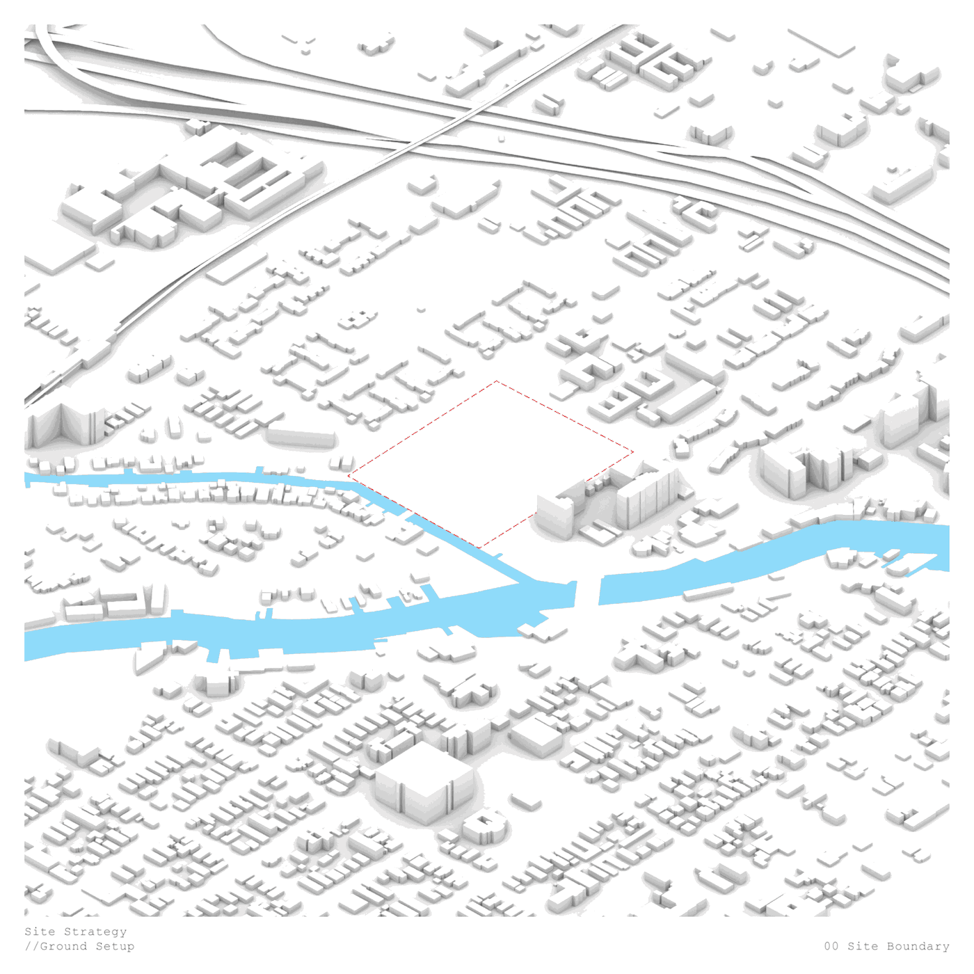
Across Racial and Infrastructural Boundaries: Integrated Park in Overtown
Across Racial and Infrastructural Boundaries: Integrated Park in Overtown
Chengzhang Zhang (MLA I ’19) and Qiaoqi Dai (MLA I ’19)
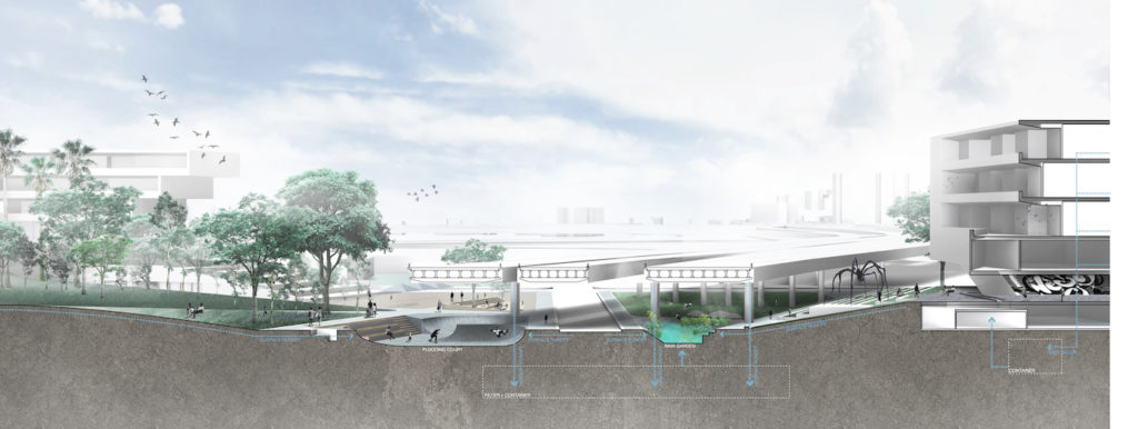
This project focuses on the Overtown neighborhood near downtown Miami. Overtown, also known as color town, once a vibrant black community, has witnessed high poverty rates, vacancy, and land speculation due to segregation by racial and infrastructural boundaries. This project proposes an integrated park, which embodies an urban strategy focusing on breaking boundaries and bringing investment for public in color town while avoiding gentrification. The project site locates on the joint of I-395 highway and the east edge of Overtown, as well as the historical color line and a freight railway. A new investment of a park on the site, proposed by Florida Department of Transportation as part of I-395 Highway extension, is unfortunately highly tourism oriented. Our proposal, on the other hand, reorients this investment to a continuous public park, which create physical stitch under the highway and over the rail between disparate parts of the community, fostering productive landscape and culture education as well as more than 600 affordable housing units as a revitalization of the community.
Making Participation Relevant to Design
By trying to understand how participation can make design more relevant to society, we can create more socially just cities. This course starts from the premise that it would not be ethical to design cities without creating meaningful conversations with different stakeholders. Our main challenge is to improve the quality and ethics of design work by staying in close contact with the city and its residents.
Participation is a way of confronting our preconceptions, revealing our blind spots, and/or supporting our intuitions in a context where architecture, urbanism, and other design-related fields are becoming more and more complex and multilayered. Participation is not an end, it is a means: a powerful tool that establishes new connections and boosts both creativity and the production of new ideas. Likewise, participation allows the construction of a collective dialogue that will engage people in different ways, formats, and temporalities. Participation is a method to enable the creation of more democratic, inclusive, and open-ended environments, redefining the very concept of citizenship.
– How can designers reimagine participatory decision-making processes?
– How should design participation unfold in an ever-changing reality?
– What improves communication and enhances creative dialogue?
– Can participatory design lead to open-ended processes or outcomes?
Among other strategies deployed to answer these questions, the class will focus on the potential contribution of digital technologies as a means for linking participation to design. Technology opens new opportunities for revealing multiple layers of meaning. It also allows the exchange of information and creation of new possibilities that together can transform the way we behave. Technology, in short, enables us to better relate and interact with each other and our surroundings, thus lowering the barriers for citizen engagement.
Throughout the semester, we will look for alternative means and untapped opportunities to identify and develop socially and technologically innovative approaches, methodologies, and tools. Students will be asked to combine technical skills and knowledge production with a social sensibility to access the direct experience of reality while also producing forms of empowerment that come from involving the relevant actors in transformative processes.
Prerequisites: None.
Visionary Architecture
This seminar will take a selective approach to French Visionary Architecture in the late 18th century. We will focus on some of the significant motifs, themes, and conceptions of architecture that course their way through the works of Étienne-Louis Boullee (1728–1799), Claude-Nicolas Ledoux (1736–1806), and Jean-Jacques Lequeu (1757–1826), among others. Our starting point will be Emil Kaufmann’s important study, published in 1952, which put these so-called revolutionary architects on the map and posited the Enlightenment as the crucial starting point for understanding modernism in architecture. We will consider such issues as the role played by drawing for presenting largely unbuilt structures, the impact of theorists such as Marc-Antoine Laugier, the relation of architectural form to philosophical categories such as Nature and the Sublime, the emergence of concepts such as architecture parlante, and the dreamed rapport between utopia and the organized city. Readings include the architects in question as well as excerpts from period texts (Burke, Durand, Kant, Laugier, Mercier, Morelly, Rousseau, and the Marquis de Sade) and modern scholarship (Braham, Etlin, Gay, Herrmann, Pérouse de Montclos, Picon, Rosenau, Vidler, and Vogt).
Course format:
Final grade based on class participation, short written responses to readings, oral presentation, and a research paper.
Prerequisites: None.
Thesis Extension in Satisfaction of Degree Doctor of Design
Thesis extension in satisfaction of the degree Doctor of Design.
Thesis in Satisfaction of Degree Doctor of Design
Thesis in Satisfaction of the degree Doctor of Design.
Preparation of Doctoral Thesis Proposal
Independent study with doctoral advisor to produce a preliminary literature review.
Prerequisite: Enrollment in GSD DDes program.
Independent Study by Candidates for Doctoral Degrees
9502 must be taken for either 2 or 4 units.
Under faculty guidance, the student conducts an independent reading program and formulates a thesis proposal. The course is intended for doctoral students.
In addition to enrolling in the course, students must download and fill out the independent study petition, which can be found on my.Harvard. Enrollment will not be final until the petition is submitted.
Independent Study by Candidates for Master’s Degrees
Students may take a maximum of 8 units with different GSD instructors in this course series. 9201 must be taken for either 2, or 4 units.
Prerequisites: GSD student, seeking a Master's degree
Candidates may arrange individual work focusing on subjects or issues that are of interest to them but are not available through regularly offered coursework. Students must submit an independent study petition and secure approval of their advisor and of the faculty member sponsoring the study.
The independent study petition can be found on my.Harvard. Enrollment will not be final until the petition is submitted.
Constructing Visual Narratives of Place
The seminar explores the representation of identity and memory in the city and its territory. The case study is Boston in its large surrounding area, the so-called Greater Boston, whose memory and identity are directly connected to the perception of its inhabitants and visitors. Such memory and the history that has characterized it since 1960—the year in which The Image of the City by Kevin Lynch was published—has influenced and conditioned the way we look at cities all over the world, the way we perceive those cities’ expansion, and how we acknowledge their new horizons.
The course aims to use this memory and identity to make visible not only the city of Boston but also the larger scale of the Greater Boston metropolitan area.
The complexity of this territory and its imageability is still something that requires deep research and interpretation. The seminar will especially consider the emerging topics of climate change adaptation, sea level rise, and their implications for the displacement of individuals and communities across physical, social, and political levels.
The observation of this area is based on two principles. The first is to define the field of survey, starting from the geographic systems and the big environmental area. The other is to have a richer and more complex picture of the inhabitants of this territory and to focus more on their collective memory and identity.
The final goal of this research and work is twofold: first, we will visually define the public image of the city on its larger scale. Second, we will explore possible future scenarios for Greater Boston, starting from the observation of the present conditions, predictions, and projections of climate change. The course intends to provide tools of observation, reading, and interpretation of the territory and it has the will to communicate stories about different visions of this metropolitan area in a more narrative way. The students will use a variety of media: mapping, drawing, collaging, shooting, and storyboarding.
The work will be divided into three sections:
1. The Big Map: Postcards by Greater Boston.
2. Short movies: The life of Greater Boston.
3. Storyboards: A new narrative for possible future scenarios in the Greater Boston area.