L’Enfant’s Latency: Camping the Anacostia
L’Enfant’s Latency: Camping the Anacostia
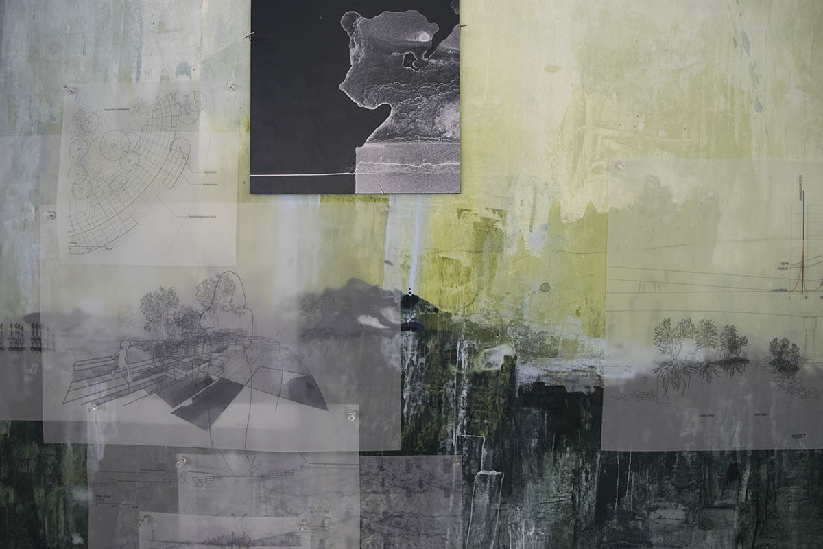
Greta Ruedisueli (MLA I ’18)
On the one hand, there are the highly regulated, pristine, national landscapes of Washington, and on the other, there are disenfranchised landscapes left out of the planning process. This thesis considers the latter as spaces to reclaim the rights to a collective public realm. It proposes an alternative to sys- tematized maintenance by embracing spontaneous occupation, highlighting the symbiotic potential of plants and humans.
“L’Enfant’s Latency” creates an environment for temporary and voluntary camping along the Anacostia River. In opposition to the Washington Mall, this reading of a collective right to the public defines a dynamic and messy democracy.
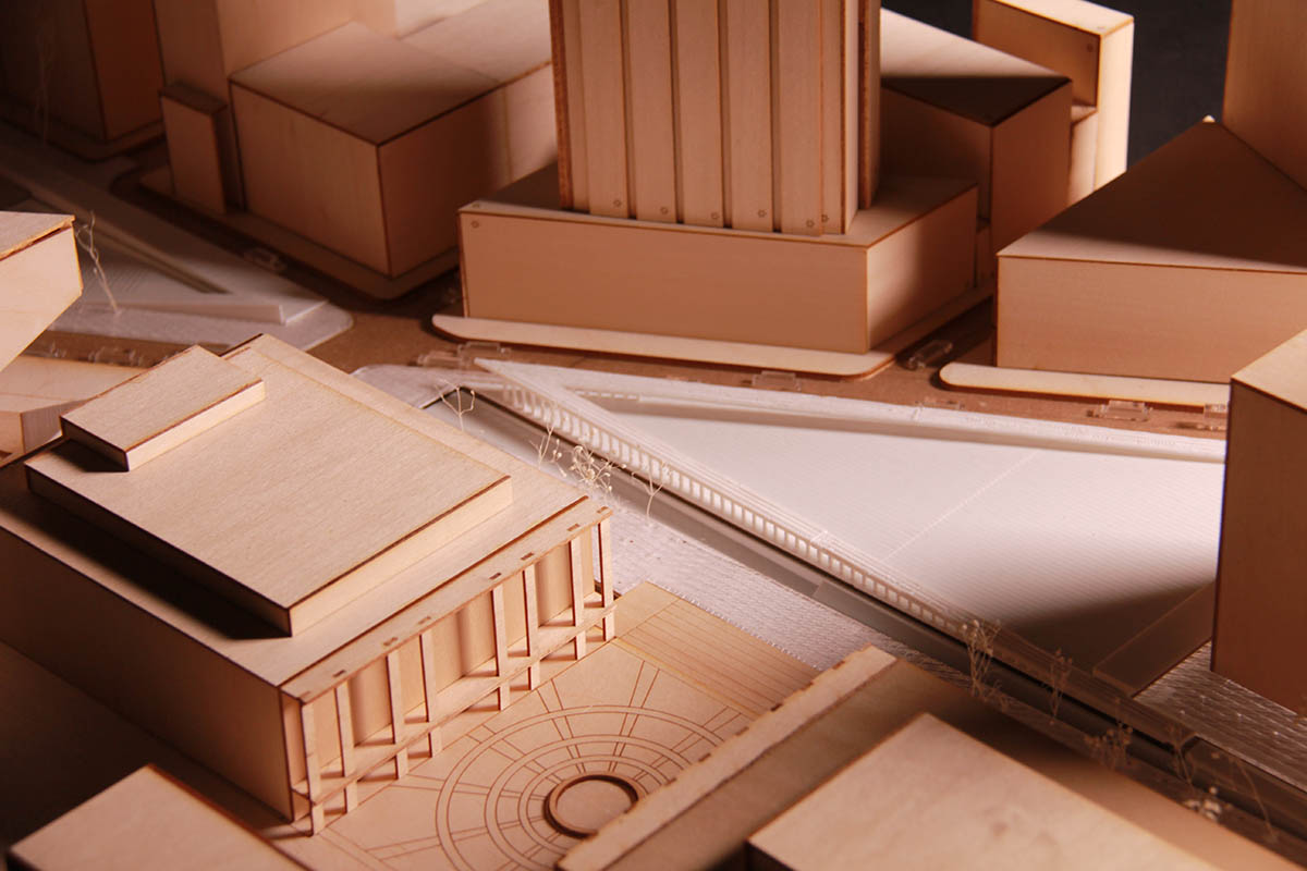
Reimagining Hamburg’s Skyline, a Trades Guild in the HafenCity
Reimagining Hamburg’s Skyline, a Trades Guild in the HafenCity
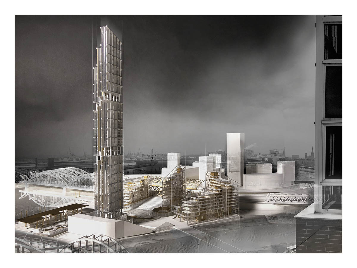
Ece Comert (MArch I ’18), Benjamin Hayes (MArch I ’19), with contributions from Oorvi Sharma (MArch I ’18) on the initial urban design
Within the cultured framework of the Hanseatic city the guild headquarters endeavors to strengthen the tectonic and mercantile traditions of Hamburg’s past with a new and vibrant urban quarter and education common in the HafenCity. Studio visits to the neighboring Hanseatic cities of Stralsund, Lübeck and Wismar revealed the symbolic and imbedded tension of a power “tryptic” in shaping the civic gravitas and urban vitality of these medieval cities, which centered around the market square, Rathaus and church. Importing the tripartite tension to the site, the urban scheme proposes three distinct urban quarters, sculpting and shaping a new public square and backdrop for a proposed tower in the HafenCity. Somewhere between the sea and the sky, the tower’s sharp blade silhouette rises, piercing the low-lying horizontal datum of the Hamburg skyline, boldly placing itself into dialogue with the spires and peaks of Hamburg’s historical churches and the newly completed Elbphilharmonie.
In Between Pitched Roof and Modernist Slab
In Between Pitched Roof and Modernist Slab
Francisco Ramos (MArch I ’19)
This project is an essay on urban morphology, architectural typology, form, and material culture. Taking the historic centre of Quito as a case study, the project seeks to explore the architectural and urban possibilities of the Spanish-American grid in order to increase the variety of living modes in this area of the city as a response to the on-going process of economic activation.
To that end, the project proposes a type of living units not present in the city centre, while embraces the opportunity to challenge the framework of intervention given by the condition of World Heritage Site of the historic core of Quito. A guardian institution in a contemporary building is proposed to set the stage for restoration and preservation of the entire block. The building –an ensemble of artist studios, housing units, domestic shared facilities and exhibition spaces – builds upon the morphology of the Spanish-American block grid at large, and the rules that shape the block also inform the organization of the building. Two new pitched roof houses negotiate the insertion of the project in context and intertwine with a modernist bar that houses residential units and offer the promise of transparency.
This project aims to activate the interior of the block and make it publicly accessible so as to reveal the entire dimension and depth of the block. This new public route on the ground floor uses the sequential layering of the colonial houses – first bay, zaguan, and first and second courtyard- but applies it at the scale of the block. Complementing the activation of the street level, a new datum is created to inhabit the roofscape, framing the mountains and establishing a dialogue with the larger landscape of the city.
Critical Intervention: Alternatives to Preservation in Mexico
Critical Intervention: Alternatives to Preservation in Mexico
Enrique Aureng Silva (MDes ’18)
Historic buildings are the physical signs of the past. They are the material evidence of other times, other peoples, and other ways of understanding life and architecture. Interpreted as such, they are frequently associated with particular historical narratives; they become the objects and recipients of cultural memories, and more often than not, they get connected to notions of national value and particular heritage discourses that tend to emphasize certain historical narratives while neglecting others.
In this way, traditional preservation practices tend to fix historic buildings in a certain particular period of the past. In order to preserve the material qualities and cultural relevance of architectural objects or urban landscapes, the methods and theoretical frameworks of preservation set historic structures, and even their immediate contexts, as landmarks worthy of protection.
But what happens when natural disasters damage historic fabric? What should be done when an earthquake hits and partially destroys a 16th-century monastery listed as a World Heritage Site? Should the same techniques and theories be applied to the natural weathering of a masonry wall as to a collapsed bell tower? What is the role that local communities should play in deciding what to preserve and what to forget?
This thesis proposes, through a reinterpretation of the concept of liminality, that the repetitive nature of earthquakes in Mexico should be seen as an opportunity for change: change in the interpretation of certain historical accounts, change in the relation between historic preservation and historic buildings, and change in the structures of power that dictate the narratives associated with them. All of these should be questioned in order to create new architectures, new urbanisms, and new social interactions that, while still reflecting on the past–on the physical and non-physical fragments left by the catastrophes–use the historic fabric not as a nostalgic element to lament loss, but as a starting point for where to imagine new alternatives.
The Half City
The Half City
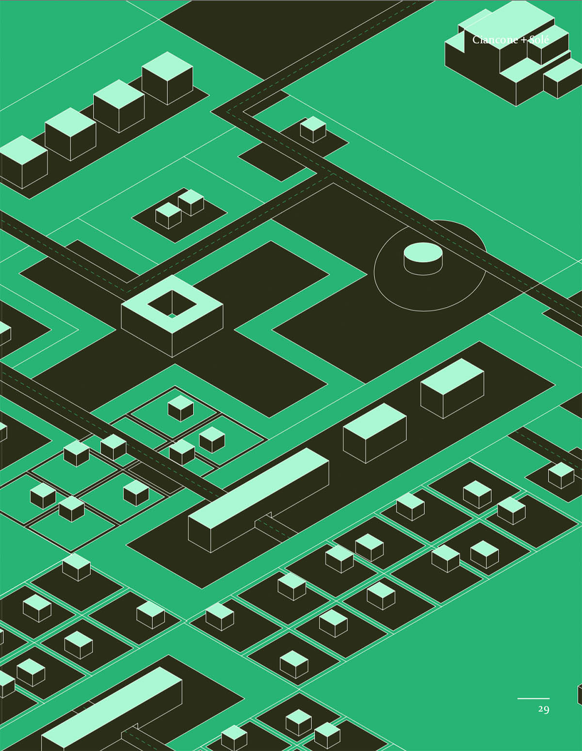
Gina Ciancone (MArch I/MUP ’18), Rodrigo Solé (MUP ’18)
Our project uses crisis as a way to construct a new model of participatory urbanization, The Half City, as a way to reorganize the rural state of Yautepec, design community empowerment mechanisms within the built infrastructure, incentivize annual employment opportunities, and decrease dependency on central authorities post-disaster.
As a historic state embedded in the export crop of sugarcane, as well as corrupt local politics, a new strategy for urbanizations is urgently needed. Using incremental, participatory urbanization termed “The Half City” our project seeks to trigger a new method of urban organization that more evenly distributes resources, as current infrastructural use and placement is controlled by centralized authorities. By designing a framework of basic requirements for each plot of collectively owned land, The Half City can be transformed based on the needs of individual owners. It is a radical new model of gradual urbanization that empowers urbanization from the ground-up.
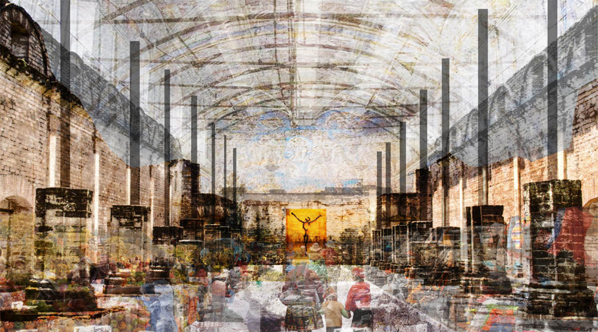
Under One Roof
Under One Roof
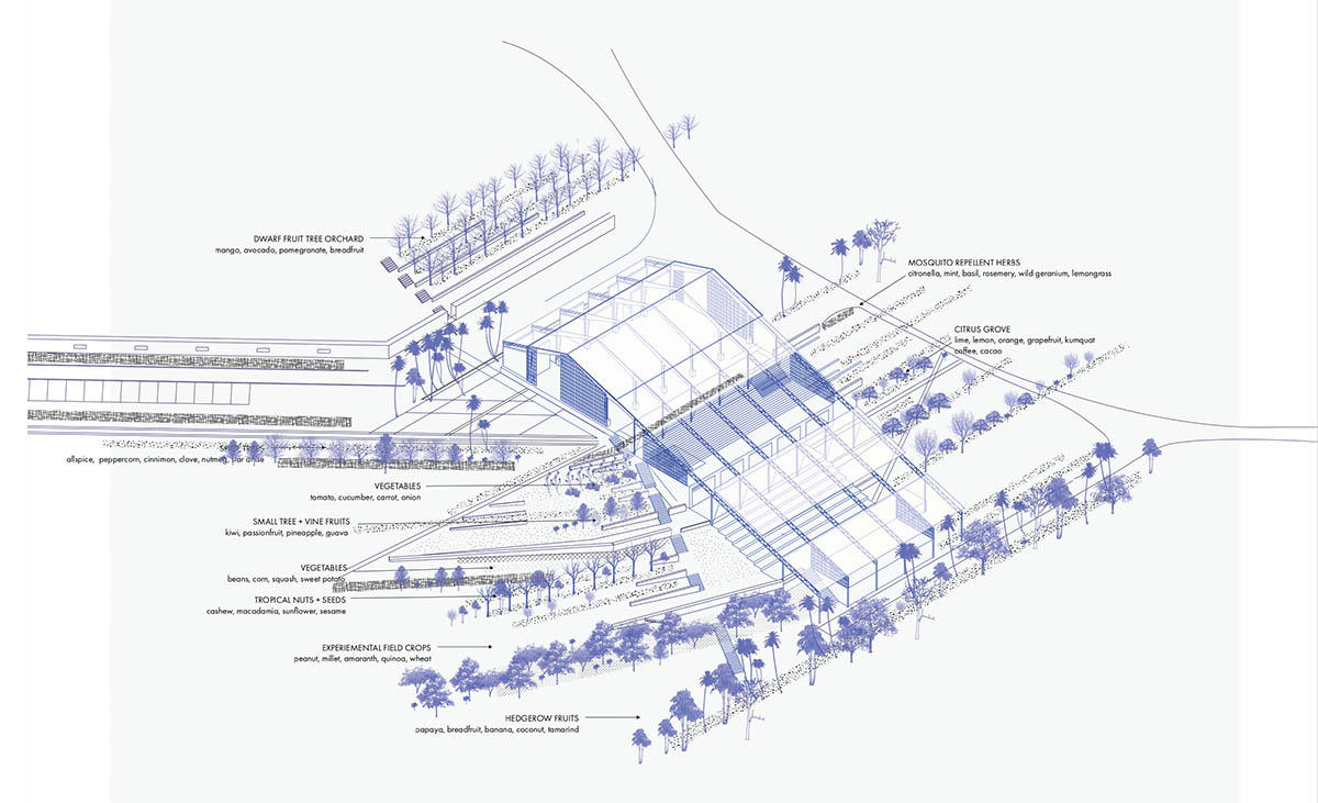
Stacy Passmore (MLA I ’18)
In the fall of 2017, Hurricane Irma and Maria caused extensive destruction on Saint Thomas Island. Recovery has been slow and difficult given that 90% of all food, materials and goods are imported to the U.S. Virgin Islands. In this context, this project proposes to redesign the damaged Bordeaux Farmers Market to foster a more self-sufficient economy by amplifying what is already “growing” on the island, such as food, natural resources, and arts. The new design extends the existing farmers market roof over the steep hillside, connecting the market to farms, and expanding its function as a dynamic community center that unifies residents, provides shelter and support during hurricanes, and develops opportunities for creative production. New indoor and outdoor terraces and structures provide space for an expanded market, an amphitheater, orchards, gardens, workshops, storage, and the production of value added goods.
Temple of Decision
Temple of Decision
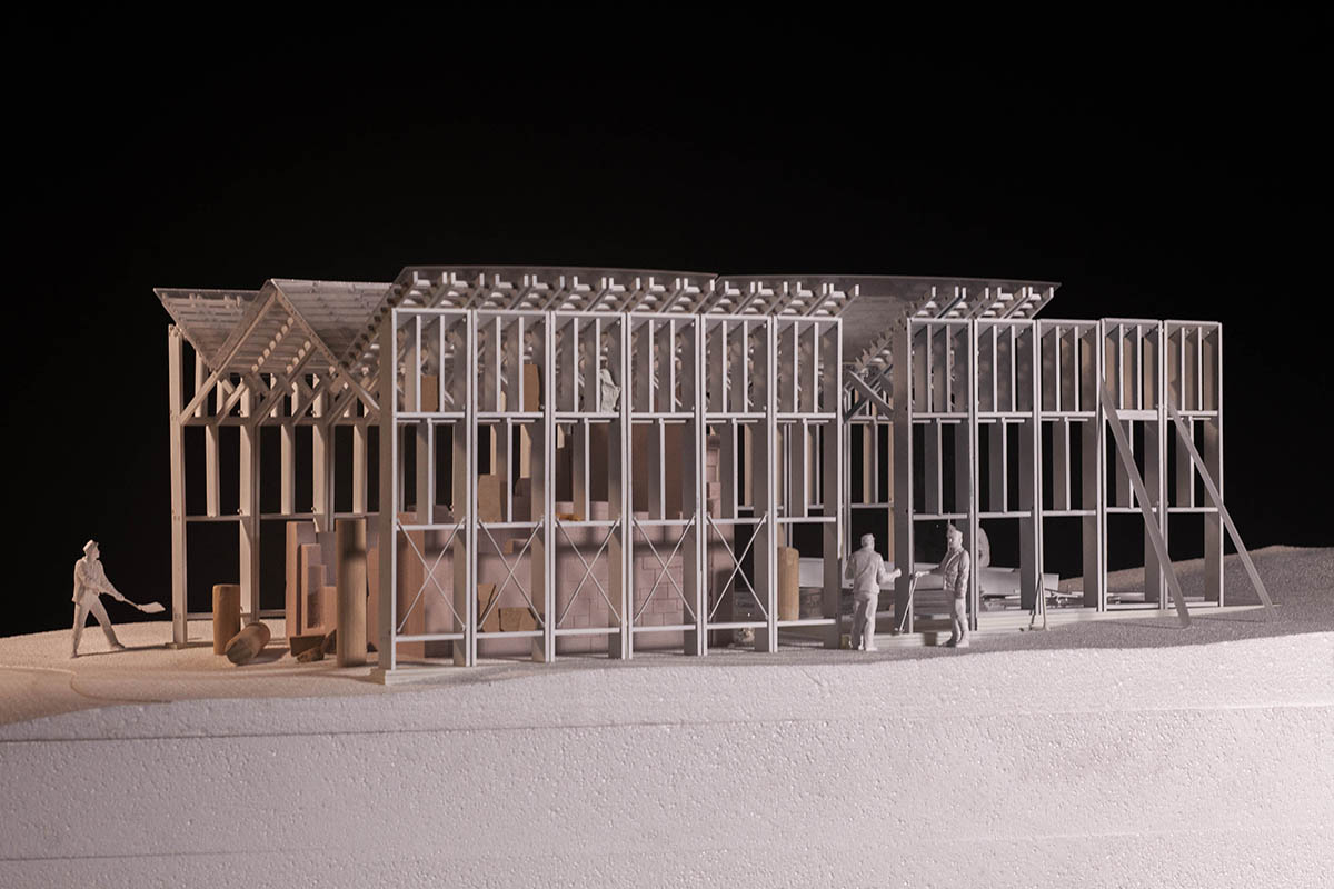
Jungchan Yee (MArch I ’19)
A Greek Revivalist garden temple, built in the 1950s, sits in ruin atop the Lomond Hills in Falkland, just an hour drive north of Edinburgh. The Falkland Estate, the owner of the land on which the ruins remain, is considering a partial restoration and conservation of the masonry structure to prevent it from further deterioration. The proposed design entails an off-site construction of wall and roof modules to be transported and installed on site.
Each of the thirteen modules spans approximately 30 feet with a bay width of 4 feet 6 inches, contains shelving spaces to collect and catalog the masonry pieces. The gabled roof profile traces the missing pediment, while the outermost roof panels acknowledge the added bays around the existing perimeter of the temple. The height of each shelf addresses the specific syntax of the Greek temple, while the vertical weight of its content collectively allow the walls to translate the lateral force of the roof.
The shed consists of thirteen modules that roughly double the existing footprint of the temple. The new area is used for conservation, a space for virtual reconstruction of the temple opposite the existing ruin. The thirteen bay structure simultaneously engages the history of the temple as a miniature copy of the Temple of Hephaestus in Athens, as the shed restores the original proportions of the Greek temple.
Water Assemblage: A new politic for the Mekong River Collective
Water Assemblage: A new politic for the Mekong River Collective
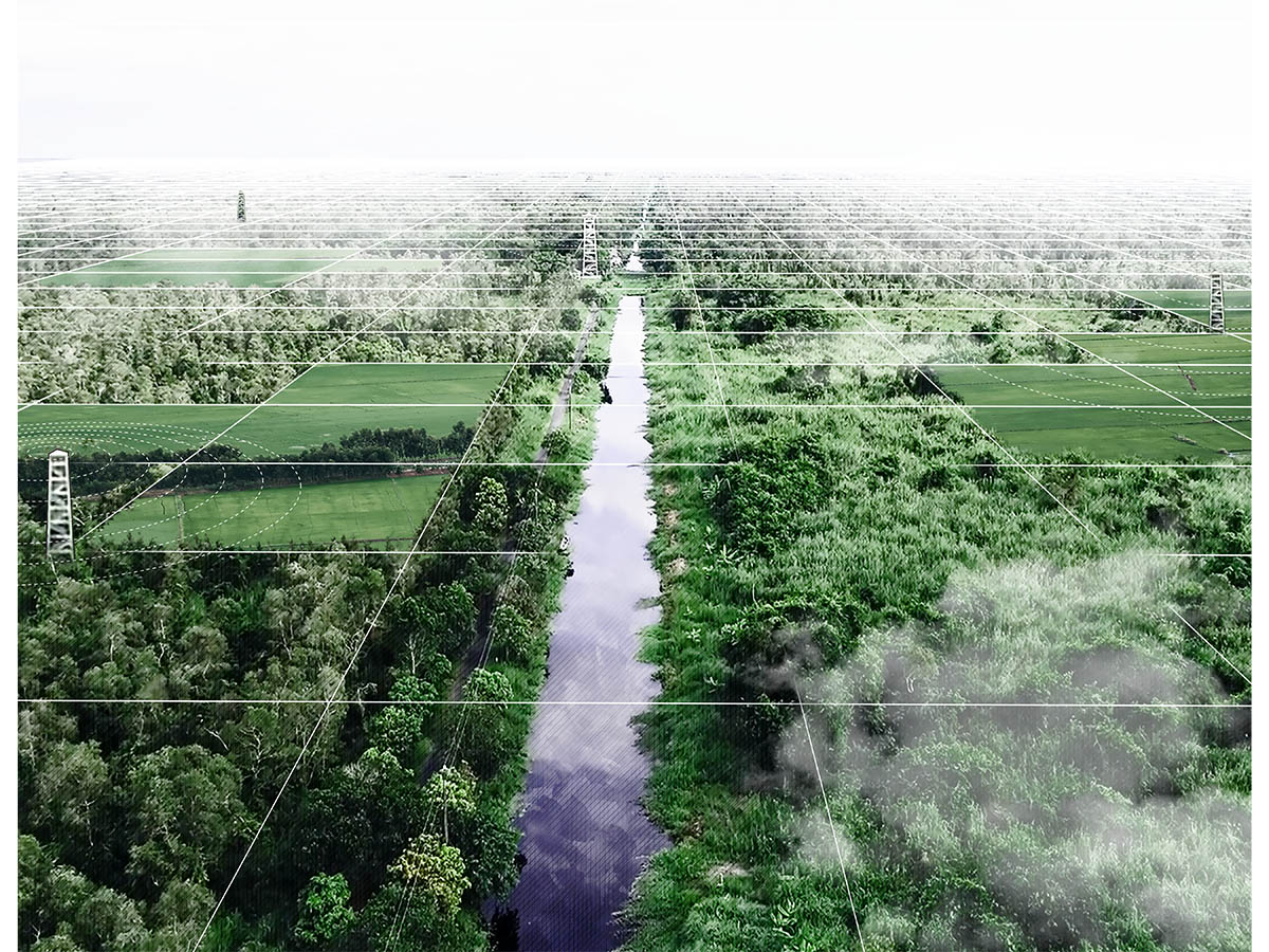
Tam Banh (MArch I/MLA I ’18)
“The point . . . is that we don’t assemble because we agree, look alike, feel good, are socially compatible or wish to fuse together, but because we are brought by divisive matters of concern into some neutral, isolated place in order to come to some sort of provisional makeshift (dis)agreement.”
-Bruno Latour
Flowing for 4,630 kilometers through the heart of Southeast Asia, the Mekong River is the lifeblood of countless wildlife and tens of millions of people across six countries. But the enduring legacy of hydropower developments that devastate its landscape and plunder the natural resources it supports is jeopardizing the Mekong’s gifts and the survival of those who depend on it.
This project explores a new working and living dynamic between the Mekong and its inhabitants by redesigning the Mekong River Commission, an intergovernmental body responsible for water resource management and development in the Mekong Basin. Sited in the Mekong Delta in southwestern Vietnam, this project examines both the institution’s form and operational structure.
Asserting that the shaping and management of river landscapes is a political issue for which all sides must be heard, this reformulation of a water management institution seeks to create new operating principles for a world in which typically suppressed voices—from farmers, fishermen, and city-dwellers to plants, fish, and birds—can constitute new forms of collective power. The design recomposes the landscape’s established power structure and affirms the urgency of seeing the Mekong River not as an exploitable natural resource, but as a political being with a social and ethical conscience.
Ungrid
Ungrid
Boxiang Yu (MLA I/MLAUD ’19)
“If there is to be a ‘New Urbanism’, it will not be based on the twin fantasies of order and omnipotence; It will be the staging of Uncertainty” – Rem Koolhaas
The street grid is a defining element of Manhattan, established in 1811 to blanket the island and it became the city’s first great civic enterprise and a vision of brazen ambition. But the system works so successfully that eliminate the peculiarity of New York city, it monopolizes the whole island’s streetscape and turn everything into identical city develop chain. The great grid gave this island the most striking feature yet takes away its personality.
Broadway is the only destroyer within the system. Along with its diagonal line, a little bit New York’s uniqueness character gradually revealed. The Flatiron Building and Madison Square park, New York Times Square, Columbus Circle, and of course, the most dramatic performance space – ‘Lincoln Center’…All of which just demonstrate that this city still has its uniqueness yet concealed by the grid. Therefore, what if I unwrap the grid and underlining the system that allows the unique point to stand out?
This is exactly what I propose to do. By deconstructing the great grid system, I filter out its influence on urban community and left behind only what is important to citizen’s mind. Their impression for the city. With only just simple geometric symbol yet bearing the deep meaning. Through shifting, transforming, distorting and contrasting to build a system, an infrastructure, a topography that can amplify the unique spatial character of Broadway. To show everyone everything that is UNGRID.
Consider Lincoln Center as a performance space, and it is an important joint on the Broadway which makes it a perfect place to highlight the uniqueness out of Broadway. Unique means different from surrounding, means a catch feature in a certain location, and means have control over what is normal. To me, to pursue the monumentality of the space is a great way to see it. Therefore, to use the tension that generate by the site car and people flow, along with the unique geometric reflect by the site to intensify the monumentality feature of the site and the uncertainty in the end, is what my project is.
Urban Design for Planners
Course Objectives
This seminar course introduces physical planners to the approaches, techniques and tools of urban design necessary to structure the spatial and dimensional relationships of the built environment. Through an individual, Boston-based project, students will be required to give spatial definition and form to an urban district through the elaboration of streets, block and building morphologies, open space networks and typologies, and urban design guidelines. This course complements the first year Core Urban Planning Studios by concentrating on the design of urban spaces – informed by but independent of – the demands of quantitative analysis, decision-making frameworks, economic forecasting or the specifics of plan implementation.
Students in this class will learn urban design strategies for integrating form and program into a framework for research, collaboration, and communication. Students will gain familiarity with the technical tools and representational techniques essential for planners to portray development scenarios.
Methodology
The parameters for the site and program will be investigated at the outset of the course in order to begin with the investigation of urban form directly. The class will develop a spatial analysis of specific sites including but not limited to block patterns and parcelization, circulatory systems, open space characteristics, and relevant regulatory restrictions – easements, waterway setbacks, etc. Working individually, students will then create concept plans for specific interventions that will be elaborated throughout the remainder of the semester. The class will review urban design approaches for similarly scaled redevelopment projects, identifying relevant case studies from a range of urban design and planning practices. Students will develop their plans through the production of an urban design presentation board or boards that will include a street network plan, a public realm plan, a taxonomy of building types, three dimensional modeling of height and setback requirements and perspectival views conveying character. Techniques of representation will be customized by each student to align with their specific project approach in an acknowledgement of the relationship between representation and spatial or programmatic ideas.
Structure
The class will meet once per week, combining lectures, discussions and design reviews of individual students’ work. Grading will be based on successful completion of the urban design document described above. This course is primarily intended for first and second year planning students enrolled in the MUP program. Students outside this program may gain access to the class with permission from the instructor.