On Adapting
On Adapting
Caio Barboza (MArch I ’16) and Sofia Blanco Santos (MArch I ’16)
On, Adapting is evidence to our belief in the tension between permanence in architecture and its constant need for adaptation. To innovate for us, is to re-view the past with the eyes of the present.
The constant transformation, processes of matter, changes of state and flows are characteristic of an ever evolving Earth in a perpetual flow. As it is the case of thermodynamics, matter and energy are constantly being exchanged, amalgamated, mixed and synthesized. In other words, they have been perpetually reassembled generating ever newer relationships. The famous philosophical Bergsonian theory of “durée”[1] calls for an understanding of duration and the passing of time as “invention, creation of forms, continuous elaboration of the absolutely new”[2]. In this understanding of time and of thermodynamics as the physics of becoming, architecture can begin to draw new associations through form, flow and matter. Our place as architects is to understand that there are now new associations possible between these ingredients as a result of the becoming of both our natural world and our societies.
The following projects – The Ascetic Hut in Santiago de Compostela, Emerging Landscapes in Finisterre, The Hedonist Hut in São Paulo and Landscapes of Convention in Rio de Janeiro – bring together new interpretations of what it means to inhabit with a deep connection to material culture coupled with a local understanding of production and consumption.
HOUSES: The Ascetic Hut, Santiago de Compostela, Galicia
The project for Santiago is thought of as a cloud. A cloud of steam. An inhabitable cloud. In contrast to the immateriality, boundlessness and transient nature of the cloud stands the stone. Grounding the pilgrims. Its thickness, its depth, its stereotomic condition. The carving out of it. The stone springs out of the granitic carpet that covers Galicia under its surface. And connects it thermally to the deep core of the Earth. The hut stands in the landscape but it can exist regardless of the inhabitants. It remains indifferent. There are no pre-determined programs in the surface of the mass. Just a topography of thermal variances, to be assimilated and taken advantage of by the pilgrims. A more primordial and primitive inhabiting of the rock. But instead of taking advantage of the concave or convex formations of the caves, desires and activities are guided through temperatures, humidity levels, wind currents, solar radiation,… It is natural to the human condition that specific programs will settle within specific conditions. Regardless, the rock will remain indifferent.
PALACES: Emerging Landscapes, Finisterre, Galicia
Conceived as a triangular-batea-like structure floating on water, the new palace of Finisterre is humble. It makes use of its new ground, the ocean water, to regulate thermal fluxes, drive activities and economy, render the spiritual, and serve as destination for the pilgrims. An oasis for fishermen, the palace is a site of production with a batea farm with processing facilities, a fishing distribution center, a retreat for pilgrims, a housing complex, a church, natural pools, and a beach.
Although composed by ordinary activities generally structured as singular and separate entities, the palace of Galicia enhances the evolving nature of the city and rising fishing industry and couples live and work under one Architecture. Here, the many dualisms present in Santiago de Compostela (the local and the pilgrim, the spiritual and the terrestrial, the rock and water, the produced and the consumed) meet. The Finisterre Palace is an end point for the pilgrims’ route, the long run for the locals, and the beginning of a newly imagined architecture for Galician coastline.
PALACES: Landscapes of Convention, Rio de Janeiro, Brazil
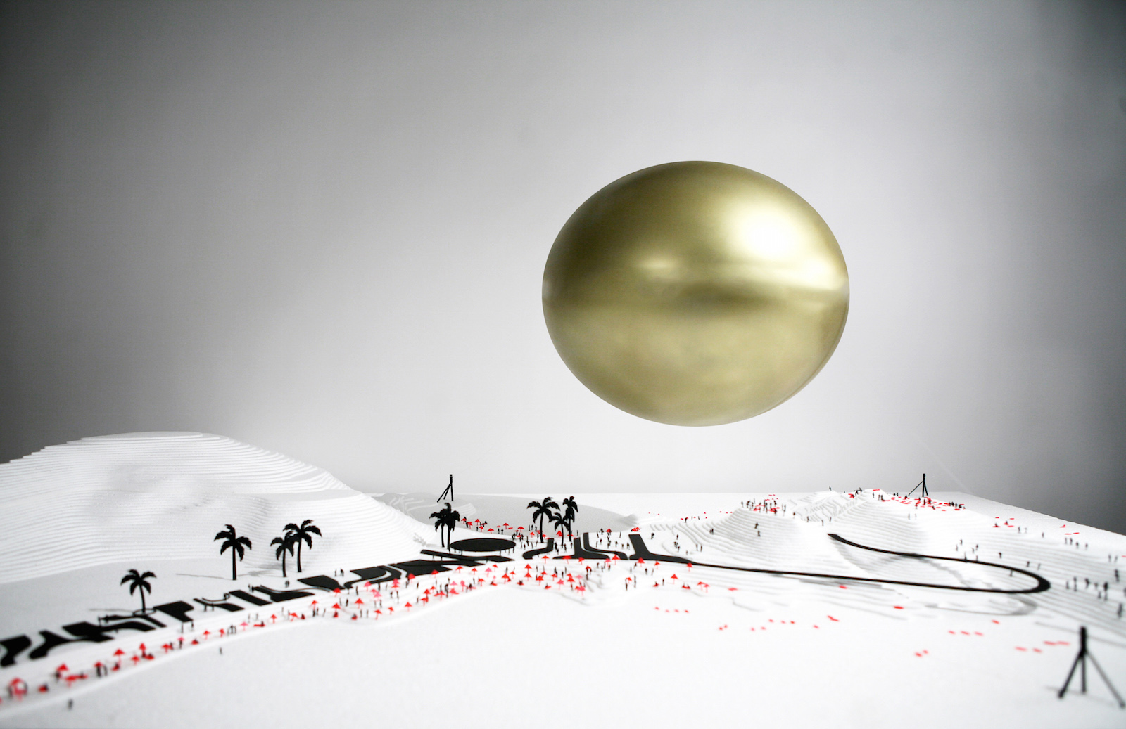
This project for Rio de Janeiro creates a brilliant volume that will float over the Ponta do Arpoador -a small and rocky peninsula between the beaches of Ipanema and Copacabana- giving shadow to the activities underneath and at the same time creating a surface on which the different colors and lights of the surrounding landscape will be captured and in which energy will be generated from the collection of solar radiation. Helium, one of the main components in the mix of gases that makes up the Sun, will be the main building element of this project.
Accompanying it, hot air will accentuate the fluctuations and variations of the architecture between day and night. Rather than being statically tied to the ground, the balloon will respond and drift according to the winds that blow at Arpoador. When the balloon’s helium and air are heated up by the Sun, Aéreo floats over the Ponta do Arpoador. The shadow of the balloon on the site will travel alongside it throughout the day. In its passing, the shadow will generate different microclimates and encourage different appropriations of the site below it. At night, when the Sun is no longer shining, the helium contained within the balloon will keep the whole structure afloat, whilst the hot air will slowly descend down to create a more enclosed structure that interacts with the rocks of Arpoador, a cave-like air grotto.
This architecture floats in the air, moves with it and stands at the borderline between the manmade and natural phenomena. Between the predictable and the unpredictable. An impermanent and constantly varying sequence of boundaries relating to material density, humidity, heat… in which occupation is implied but undefined, in which programmatic determinacy does not matter. In which people are constantly responding and made aware of changes in their surroundings. As such, the project explores a notion of inhabitation that is exterior, that stands in the tension between the project and its surroundings, exposed and ever-changing with the shadow that Aéreo gives on the Ponta do Arpoador.
HOUSES: The Hedonist Hut, São Paulo, Brazil
The Hedonist Hut challenges the capacity to operate fairly simple and complex programs concurrently in a type of inside/outside pavilion while not losing sight of aspects that shape and characterize what it means to be Brazilian. With its clichés, controversies and attitudes, Brazilians are worldwide known for their particular approach to life. It is in keeping with that tradition, that the Hedonist Hut takes those conceptions to play and elevates them to a linear and sequence of events based on the 7 Capital Sins by associating each one with a room.
The hut is therefore a pavilion made up of seven rooms with each of them responding to a certain activity much bounded by its own kind and in the open air. These rooms become voided from the shadow, carved out from the shade of the fins. Hierarchy is best manifested in the hut’s architecture. The roof, conceived as a highly calibrated blanket of sorts, straddles all programs. It is the predominant figure among all rooms. The roof’s precision in increasing the thermal comfort is manifested by the numerous conditions of shading and thermal massing it achieves through the shades – while being simply inanimate. Instead, we let the movement take place on the ground through the movement of the shadow.
[1] Henri Bergson, “L’Évolution créatrice”, 1907.
[2] Ilya Prigogine and Isabelle Stengers, “La Nouvelle Alliance”, 1978.
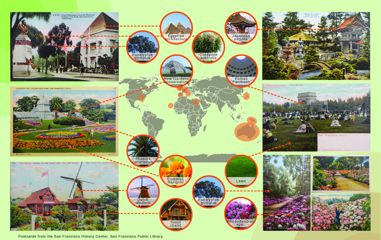
Un-Greening Golden Gate Park
Un-Greening Golden Gate Park
Heterotic Architecture: Stacks, Chimneys & Chutes
Heterotic Architecture: Stacks, Chimneys & Chutes
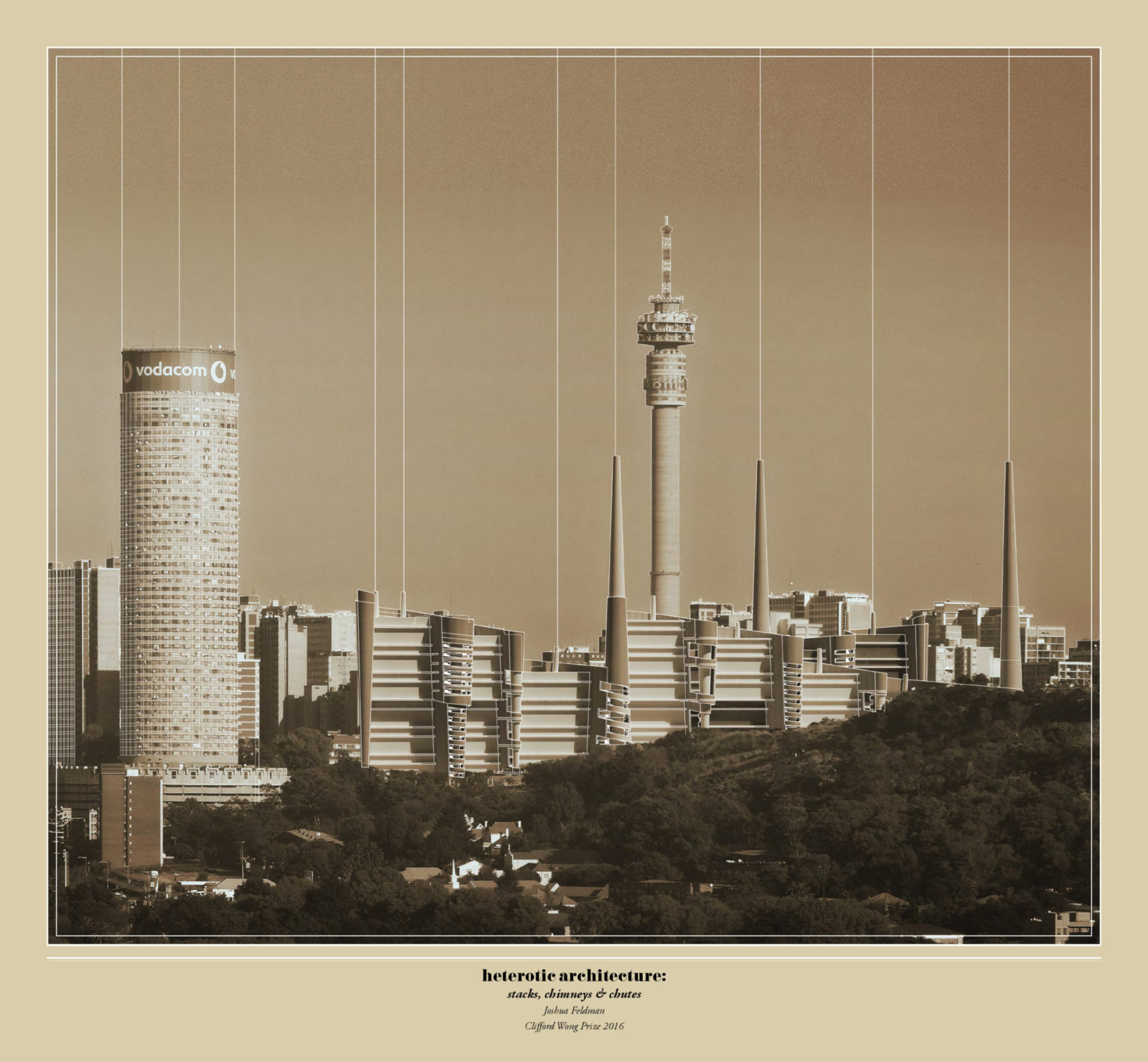
Joshua Feldman (MArch I ’16)
The taut line between hybrid vigor and sterility dares our mastery.
– Kenneth L. Kaplan, Hybrid Buildings
Heterotic Architecture proposes a synergistic integration of programs through formal, functional, and urbanistic exchanges. Heterosis or hybrid vigor, referring to the improved functioning of a hybrid offspring, offers conceptual potential for the project to explore the interbreeding of disparate programs to produce a mutually symbiotic relationship, as opposed to a mere juxtaposition of functions. This project investigates the heterotic architectural implications of combining a waste-to-energy facility with housing in Johannesburg, South Africa. In doing so, the project pairs energy producer with consumer, industry with housing, and peripheral with centrally located program.
Given increasing urbanization rates, global solid-waste generation is accelerating, presenting a looming crisis in the treatment and management of waste. Much of the increase is expected to come from fast-growing cities in developing countries, such as South Africa, which currently sends 90% of its waste to landfill. The project is located in the heart of Johannesburg’s inner city, adjacent the iconic Ponte tower in the residential neighborhoods of Hillbrow and Berea. Together, these neighborhoods have combined density of 67,500 people per square kilometer, far exceeding Hong Kong at 25,000 and New York City at 10,000. Within this context, the combination of housing with a waste-to-energy facility offers relief to overcrowded surrounding buildings and serves as an effective infrastructural link in the management of the city’s urban metabolism.
Inspired by the historical and cultural trajectory of the futurist imagination shaped by Sant’ Elia and others, the project embraces the formal potential and industrial identity created by stacks, chimneys and chutes that punctuate the elevation. The stacks not only release clean steam from the waste plant below, but also serve as circulation points for the housing units and act as urban beacons within the city. Given Johannesburg’s primarily warm climate (with wet, hot summers and dry, moderate winters) and the poor air circulation inherent to a dense urban context, chimneys are engaged to improve ventilation within the housing units. High pressure steam from the waste plant turbine is circulated within and around the openings of the chimneys located at the northwest side of each unit to draw air through the apartments. Elevated gardens are woven between the units and incorporate chutes for collecting resident waste. The building is raised above ground level to maintain the ground plan as a public space, comprised of a promenade and recycling center on the west, a central green space, and a recreation and sports area on the east. The impact of the project extends beyond the site, as the waste plant provides district heating and electricity for 400,000 city residents and processes 362,000 tons of waste annually.
An undulating façade weaves around the units, open spaces, and vertical elements, absorbing disparate components into a unified whole. In this way, the project resists singular readings as either a residential complex or a waste-to-energy facility. Instead, it proposes a new form of housing, which recasts the symbolic meaning of chimneys, stacks and chutes.
In combining housing with the waste plant on a centrally-located urban site, this project reimagines the way in which we live and rid ourselves of waste. Hybrid vigor is explored through the cross-breeding of programmatic requirements and integration of form, the thermal exchange between the housing units and waste plant, and the urbanistic value created by recapturing waste and maintaining the site as a public amenity.
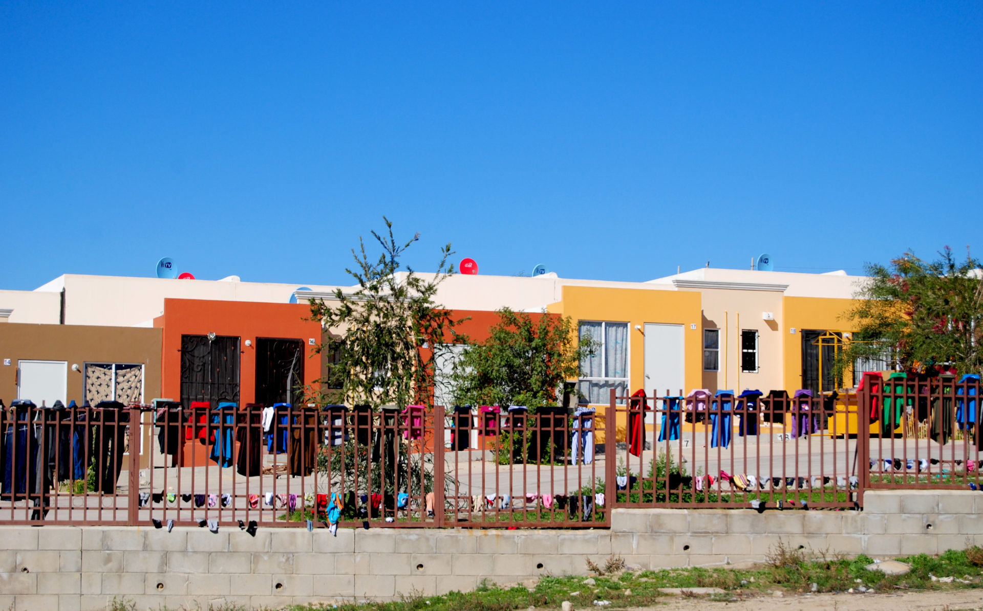
Te Vas o Te Quedas? Variations in the Explanations for Housing Abandonment in Tijuana, México
Te Vas o Te Quedas? Variations in the Explanations for Housing Abandonment in Tijuana, México
Francisco Lara-García (MUP ’16)
Tijuana, a city along the Mexican border with the United States, is currently suffering from a housing abandonment crisis. Various interpretations have been offered to explain the occurrence of the phenomenon, but none of these satisfactorily account for the uneven distribution of abandonment in the city. Through a mixed-methods investigation, this study explores the variation in explanations for housing abandonment. It finds that the “distance” that stakeholders have from the problem of abandonment has an effect on the complexity of explanations that these actors are likely to offer. It concludes with a discussion of the implications of this finding on Mexican housing policy, ending with prospective policy paths that could incorporate more effective multi-scalar, multi-agent approaches to housing provision.
Thesis Advisor: Diane Davis
Towards Sentience: Attuning the Los Angeles River’s Fluvial Morphology
Towards Sentience: Attuning the Los Angeles River’s Fluvial Morphology
Leif Estrada (MLA I/MDes ’16)
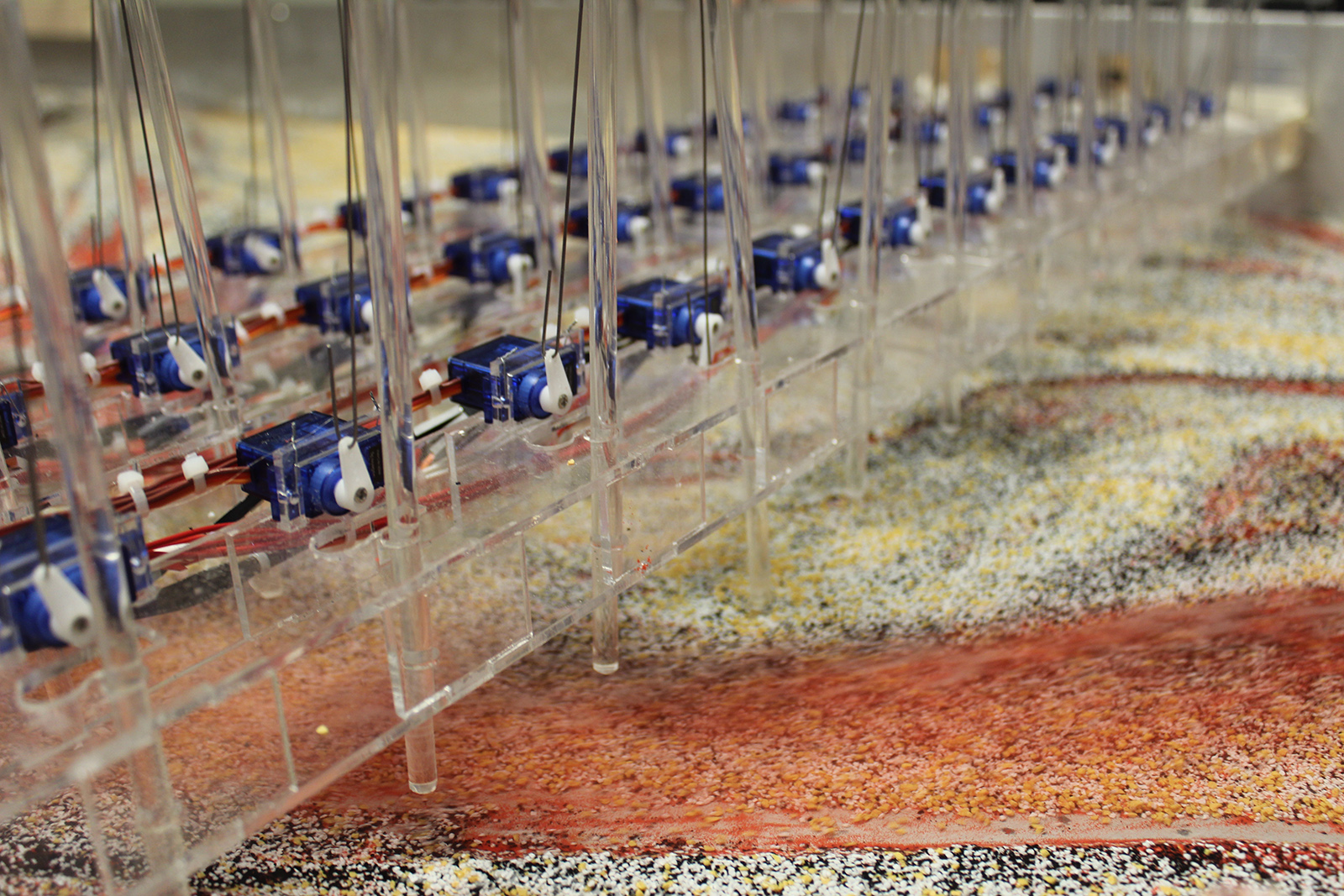
This thesis incorporates the design of a robotic machine, which will attune the fluvial morphology of the LA River through a series of real-time sensing and responsive manipulations as a way to curate the projective successions of the river—constantly altering and modifying the riverine landscape, privileging the evolution of ecological processes over static constructions.
The machine will learn from initial site conditions of the LA River, but also from the modifications it will produce independently. The landscape machine will eventually become sentient, through learning from its environments, iteratively honing on specific operational processes:
to erode the existing concrete lining;
to attenuate flows of water and sediment in order to accrete new temporal landforms;
to infiltrate the subterranean arid landscape of LA and charge new aquifers;
and to predict the successive planting that would endure the projective new Nature of the river.
Sentient-ly, it will attune the fluvial landscape—to a level of degree that man is incapable of processing in order to respond and modify the landscape in real-time. Projective-ly, sentient machines will be created to aide landscape architects and designers to address human’s incapability to negotiate complexities that occur in real-time, which necessitates immediate responses. Through this new imagined sensory, it will enable the emergence of new forms of landscape, which was not possible without the machine’s new dimensions of sentience.
Theoretical Framework
Rejection of the dichotomous image created by ‘the manmade’ and ‘the idealized’ untouched image of Nature was brought on by technological advancements humans developed for modifying all known Natures.
Such production brings upon an anxiety as to what was once natural. Through our ability to create and conceptualize hybrids of biotic and abiotic systems, we have also facilitated the evolution and image of novel ecologies. Furthermore, design is consistently introduced to “tame” newly-ostracized biologic systems to human will. To legitimize uncanny creations, humans find and extract any economic and practical capacities. However, despite levels of human control, there is always a moment in which a system will fail.
Today’s systemic failures, re-situate novel ecologies in the contemporary realm of “uncontrolled environments.”
Can responsive systems learn from the living landscapes? Can sentient machines mitigate foreseeable systemic failures, as well as facilitate the emergence of novel ecologies?
This thesis incorporates the design of a machine that will learn from initial site conditions, but also from modifications it will produce independently. The landscape machine will eventually become sentient, freeing itself from man’s control. Autonomously, it will act as a non-subjective author—constantly altering and modifying landscapes, privileging the evolution of ecology over static constructions. Future landscape designers will be creators of autonomous, human-value reinforcing machine because, as individuals, we have lost touch with our ability to negotiate the complexities of our relationships with non-human actors throughout all of earth’s landscapes.
A shift in what has become the accepted norm concerning ecology is necessarily upon us.
Project Website:
towardssentience.com
OBJECTHOOD
OBJECTHOOD
Liang Wang (MAUD ’17) and Lu Zhang (MAUD ’17)
The contrast between particular and universal, between individual and collective, emerges from the city and form its construction, its architecture. This contrast is one of the principal viewpoints from which the city will be studied. It manifests itself in different ways: in the relationship between the public and private sphere, between public and private buildings,between the rational design of urban architecture and the values of locus or place.
— Aldo Rossi
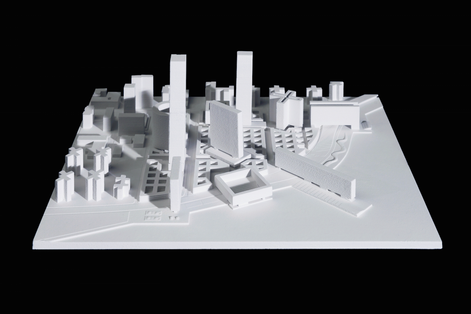
This project explores a new urban housing model that hybridizes the collective urban grid and the individual urban objects, from which the domesticity and life styles emerge to inform new urban ramifications at different scales. The urban objects here could be deciphered at two scales: one as urban fragments that mediate spatial and programmatic relationships with the city, one being the aggregation as a whole constructed at a larger scale, in which way we call it objecthood.
The project starts with the observation of contemporary New York housing fabrics, where exists a clear division between typical Manhattan grid and the Towers in Park typology. These two dominant types form the urbanism across Manhattan and beyond, each presenting unique spatial organization and life style embedded within. Based on this observation, the design proposal examines a hypothesis of combining those two urbanism: the normal grid and the abnormal objects, as a basic urban housing model to construct the city. Therefore, instead of using the existing Manhattan grid structure, a new grid module extracted from the basic Manhattan plot of 25ft is introduced to reconfigure – the courtyard system with generic dimension of 50ft by 50ft. It is the generic urban container of housing and infrastructure, which at the same time responds to the specific site constraints of FDR and the urban edge. The second system of series of objects introduced into the site holds public amenities and various housing types. The place where grid reconciles with the objects gives the public amenities shape and generates another layer of public space, being the recreational programs connected by a loop and landscape that ties the project to the city at a larger scale.
The emergence of universal urban grid and particular urban objects not only addresses the concern of urban multiplicity, more significantly, it informs a new urban housing typology at both programmatic and social levels. The spatial arrangements makes possible the coexistence of diverse living styles for multi-families, and its programmatic amenities embody the vision of a new social order which emerges as framework of the living community.
As a vision, this project is conceived at the scale of both a super block and a single bock, and the strength of the project resides in the duality to accommodate a variety of the scales and life styles from superblock to block and from city to buildings. As an urban experiment, this project serves as both an urbanistic housing strategy and a social framework. It could be re-adapted into different urban contexts with various parameters accordingly, thus to respond to the dynamics of our city today at large.
CITY HALLucination: The Arching Attitudes of City Halls from Surface to Type
CITY HALLucination: The Arching Attitudes of City Halls from Surface to Type

Trax Yinan Wang (MAUD ’16)
This thesis aims to examine the role of city hall as an acupuncture architectural and urban design project within the American urban landscape across from the urban center to the urban edge. The first half of the thesis is a taxonomic research, which examines the arc of attitudes towards the political, social and spatial dimension of city halls across time in the context of American cities. The second half of the thesis is three design proposals with the intention of deriving new designs and understanding of the city halls that aim to set the 21st century terms for a sense of the commons, democracy and monumentality which move from surface to type. This thesis is important because it would open up a discussion between the original manifestation of the city hall, current attempts to accommodate a larger suite of cultural and civic activities, and, in reality, the frequent lack of civic activities in many contemporary city centers.The project would also discover a transition from surface to type for contemporary city halls that revives the sense of the commons which was lost, in particular, a type that might be able to both meet the administrative needs of city government and catalyze a new sense of public space with multi-functional urban activities across the various urban landscape.
Thesis Advisor:
Felipe Correa
Final Review Presentation
From Terroir to Territory: Vineyard Public Space
From Terroir to Territory: Vineyard Public Space
Alexander Cassini (MLA I ’16)
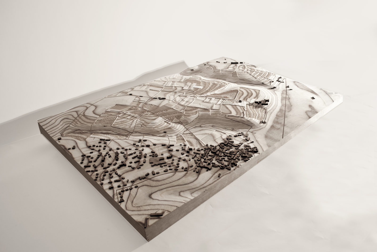
The French concept of terroir claims that characteristics of place can be traced through a wine’s taste. Yet, today local characteristics tend to be overshadowed by the globalized wine-market where large corporations shape the production, distribution, and consumption of wine worldwide, creating wines with a uniform taste. In the Loire Valley, there is a counter current whereby a growing number of its vintners have reintroduced traditional and ecological growing techniques to bring out the true taste of the terroir in the wine.
Using site-specific and economical means, the thesis provides the rudiments for a shared public space. A seasonally-revolving public vineyard space expresses local rituals, site and soil particularities, and unique micro-climates. This public space fosters people’s understanding of the necessity for the particular in vineyard landscapes thus demonstrating how public vineyard space can express terroir.
Over 100 000 people per year migrate from urban to rural areas in France seeing the countryside as an attractive destination. Yet, this “neo-rural” lifestyle is disconnected from the surroundings and opportunities for exchange and understanding of viticulture are limited. This thesis vouches for developing vineyard public space through a deeper manifestation of terroir thus reconnecting locals with their surroundings. The vast territory of vineyard tracts in the Loire Valley is the ideal locus for a unique and temporal public space blending productive, ecological, didactic, and contemplative purposes. The vineyard becomes a complex public space—a space of exchange and strengthened social ties among producers, locals, consumers, and tourists—that offers a model for reordering the experience of the territory.
Faculty Advisor: Gary Hilderbrand
KAWAII-KOWAI Amplifying the Affective Loop
KAWAII-KOWAI Amplifying the Affective Loop
Erin Cuevas (MArch II ’16)
The proposal in Tokyo addresses the duality between Kawaii and Kowai — two Japanese words with similar phonetics, but opposing meanings. Kawaii denotes a purity, innocence, and femininity, while Kowai, on the other hand, denotes fear, danger, and perversity. The architecture provokes the overlapping of Kawaii-Kowai in terms of social interaction and subjective perceptual experience. Layers of concrete delaminate to enclose product showrooms, and a series of varied apertures allow for dual peepshow-panopticon interactions surrounding a central atrium. The design embraces human and architectural alias, translating space into profitable advertisement, ultimately integrating architecture into a feedback system where immaterial culture is both consumed and produced simultaneously.
Thesis Advisor:
Iñaki Ábalos
The Littleton Trials
The Littleton Trials
David Kennedy (MDes ’16), Jacob Mans (MDes ’16), and Benjamin Peek (MDes ’16)
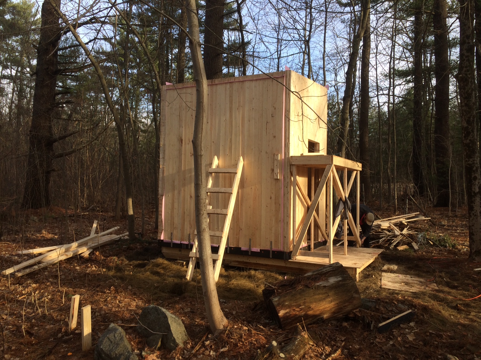
This inquiry seeks a method for identifying feedback indicators that operate across scales in mass timber buildings. Reinforcing feedback loops offer an alternative metric to efficiency-based performance indicators that operate solely within the envelope boundary of a building. The project unfolds across the design and construction of three wooden huts at the Prouty Woods in Littleton, Massachusetts. We dissect wood across scales to understand how material-scaled thermodynamic variables, building-scaled construction logics, and landscape-scaled forest management regimes can operate as non-linear feedback loops that shape trans-scalar design decisions.
Our methodology leverages observation, making, and occupation across scales to inform a theory of design research and practice that engages architecture as an open system. Wood, as our explorative media, diverges and converges through the act of construction and testing. The design iteration and construction of Trial Hut001 focuses on characterizing different mass timber construction logics (nail-laminated timber, dowel laminated timber, nailed cross laminated timber, and doweled cross laminated timber). The design iteration and construction of Trial Hut 002 focuses feedback from the initial trial and modified it through the introduction of critical New England wood species to understand the impacts of a multi-species wood construction across scales. The design iteration and construction of Trial Hut 003 converges feedback from the first two trials into a set of thermally tuned multi-species wood panel concepts informed by the de-construction of existing construction logics and the incorporation of different local wood species.
The project is continuously changing and redefining as it tracks opportunities opened by our collaborators and the trials undertaken during the construction and testing of aspects of the project. Trial Hut003 embodies a number of critical feedback loops that begin to connect local forest management practices to heat transfer considerations at the scale of a building. The project embodies the formation of a method for design research that leverages the physical medias of large-scale making and material organization into a critical abductive process. This method is an alternative model that couples academic research with professional practice–a critical alignment that bridges the academic and commercial realm.
Final Review Presentation
Sponsored by Softwood Lumber Board, Northeastern Lumber Manufacturers Association, New England Forestry Foundation, Massachusetts Department of Conservation and Recreation, and the GSD Energy, Environments, and Design Lab