Discourse Practices
This course takes stock of the proliferating media and institutional frameworks within which architectural research takes form. We will understand these discursive modes–publications, exhibitions, installations, labs, collectives, pedagogies, policies, among others–as sites where architectural thought moves between the documentary and the propositional. We will look broadly at the landscape of discourse practice with the aim of thinking together about the particular affordances, limits, materialities, methods, reach, and politics of these various modes of working, and we will approach our topics on historical, theoretical, and practical terms.
This course will be comprised of lectures that introduce a range of historical and contemporary discourse practices, seminar discussions of texts (historical, theoretical, and otherwise) that might animate our understanding of those practices, and, finally, practical workshops. Participants in this class will be expected to lead reading discussions, formulate a research proposal, and examine a particular case study (historical or contemporary) through an in-class presentation and final paper.
Building Resilient Communities
This seminar course will examine resilience of communities to natural and man-made disasters, climate change and other vulnerabilities. It will do so with an objective of finding ways to create resilience in communities that are apparently ‘weak’. Many communities in the world today are vulnerable to environmental and man-made threats. In many cases there is not sufficient help from governments and organizations to create resilience in such communities. In such instances the people have to rely on their own strengths and abilities. The course will emphasize the ability of the people to develop resilience with the skills and knowledge they possess with some support from technical inputs. The key being self-sufficiency.
There will be discussions and guest lectures on the topic from various parts of the world. Through these and suggested reading material, students are expected to identify a community of their choice, anywhere, and develop a resilience strategy for the same, preferably using community skills and strengths. This will be topic of the final paper. There will be interim presentations on this with comments and suggestions from the tutor. Students are also expected to submit summaries of the discussions and presentations every two weeks.
Students are expected to develop a better understanding of how to address vulnerabilities in communities that need it and develop strategies for the same. One important point is to be able to identify the strengths and skills of the people at risk and how they can be applied independently for their own resilience.
Machine Aesthetics: Transcoding Space Time
The use of generative AI models increasingly involves the reliance on a few black box pretrained and centralized models where design intent is conveyed through language prompts. However, language is an imperfect medium for conveying design and artistic intent especially in the visual arts and architecture.
Underpinning modern AI is a multitude of techniques borrowed from data science, digital signal processing, information theory, computer graphics …. The machinery of Machine Learning and information theory provides a unified framework for representing, analyzing and synthesizing data, regardless of whether these data map to images, sound, 3d models or something else.
In this course we will explore the creative potential of Machine Learning and Signal Analysis techniques when we treat the environment and the things we create as signals. This year we will focus on the transcoding between temporal and spatial forms, with emphasis on the relationship between audio and three-dimensional geometry.
We will visit certain audio and video analysis techniques including the Fourier transform, various types of spectrogram and ML tools, that will help us extract structure from temporal artifacts. Students will have an opportunity to familiarize with certain concepts behind signal analysis that offer us alternative ways to think about and connect the structure of temporal and spatial objects.
In addition, new will look at several techniques for synthesizing three dimensional objects that are suitable for these types of workflows.
Students will work in small groups to design and produce a three-dimensional object/space/interactive installation or experience, virtual or that represents a temporal object (a piece of music, video, performance, time series data…). The emphasis is on how the structure of one object (geometry, curvature, rhythm …) maps onto another.
The class is structured as a small studio with a series of workshops introducing the tools necessary. No coding knowledge will be required but coding material and technical discussion will be offered to students that are interested and have prior knowledge.
When possible, all material in class / workshops will be given in three different versions, Unity3d (with emphasis on interactivity / real time), Grasshopper (with emphasis on geometric operations), Scripting (for advanced students that want more customization). Students are free to choose the technological framework that matches their project and technical knowledge level.
Displaced Becomings –The Many Faces of Modern Architecture in Sinophone Asia
I have no nation now but the imagination.
Derek Walcott, The Schooner Flight
The idea was that in [a] society, one that’s incompletely modernized… the temporal dynamics of that society, and of the modernism that it produces, will be much more striking… [I]t is through the experience of time that modern is apprehended.
Fredric Jameson interview with Michael Speaks
Jameson on Jameson: Conversations on Cultural Marxism
Modern architecture was much more than “the International Style,” as proclaimed by the vanguards in 1932. Modern architecture sprang up all over the world, in all political systems, in all geographical regions, in all kinds of conditions specific to each case. In many cases, through the drift and shift of transformation, adaptation, and intervention, modern architecture gained momentum going forward and expanded its foundations both professionally, theoretically, and socially. After all, modernity also indicates battling the preexistent colonialism, imperialism, neocolonialism, as well as institutionalized chauvinism of all kinds. Such is the case with modern architecture in Sinophone Asia, which includes Mainland China, Taiwan, Hong Kong/Macau, Singapore, and some parts of Nusantara, the Southeast Asian archipelago. These are the cases, topics, and areas that the course covers.
The course provides an exploratory study of the histories, theories, ideologies in which the discipline is practiced, as well as currently practicing over time and across cultures and geographies under the umbrella of “modern architecture.” The idea is to call for a [re]discovery of the multiplicity and diversity of modern architecture. The emphasis is on a plural reading and understanding of modern/contemporary architecture through multiple cultural and critical lenses. The lecture discusses significant projects, prominent figures, noteworthy historical moments, and momentous social and political events. The lecture also examines architectural movements and other-isms, as well as offers a glimpse of the recent Grands Projects and the work of the emergent generation.
The course is structured around faculty presentations, guest lectures, and collective discussion. The students will be tasked with completing two assignments. The first is a case study assignment, and the second is a short end-of-the-semester paper on a topic related to the course. There are no prerequisites.
Walnut Park Place: Affordable Ownership Opportunities for the Egleston Square Community
Walnut Park Place: Affordable Ownership Opportunities for the Egleston Square Community
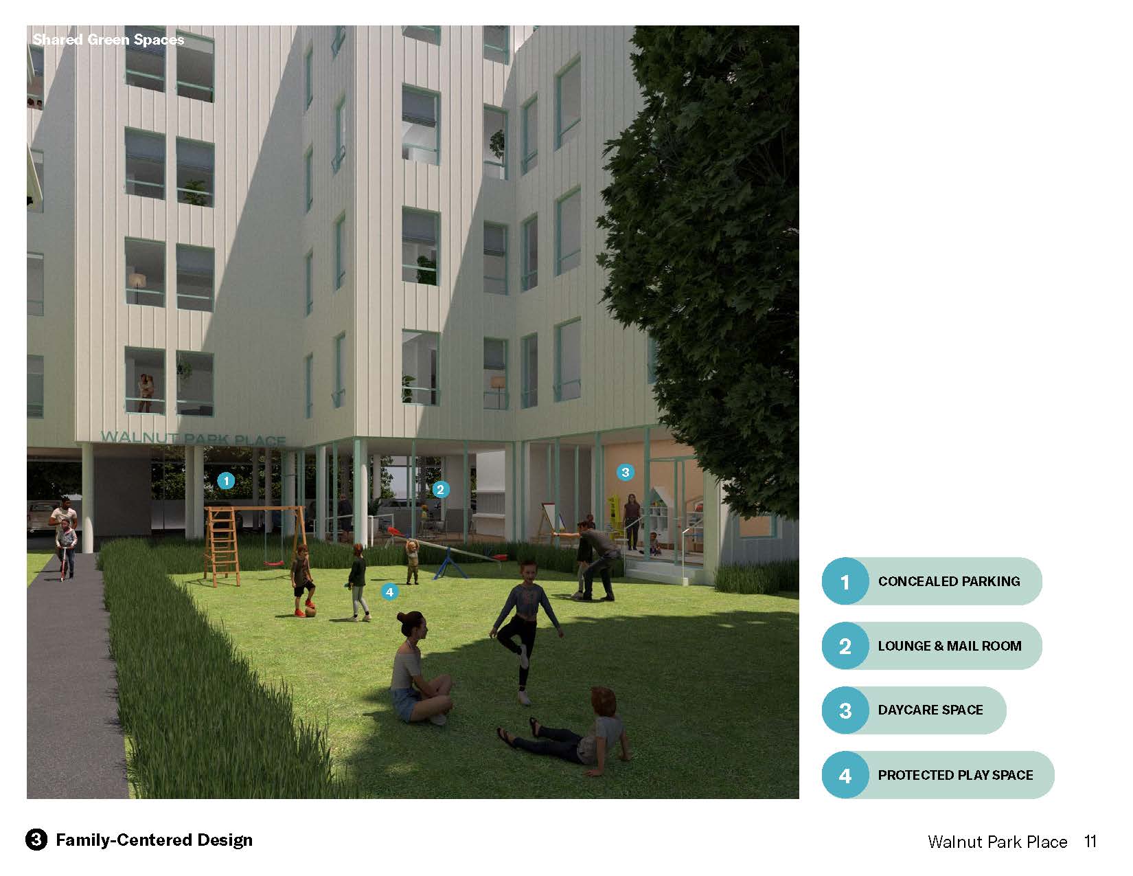
Aaron Smithson (MArch/MUP ’25), Cat Chen (MArch ’25), and Maggie Weese (MUP/MPH ’24)
Walnut Park Place is a 29-unit affordable homeownership development in the Egleston Square area of Roxbury. Designed with sensitivity to both its physical context and the stated needs and desires of local residents, the project leverages both public sources and residential cross subsidy to provide middle-income Roxbury families with an increasingly rare opportunity to establish enduring roots in a fast-changing community. Walnut Park Place utilizes a family-centered design approach, incorporating a ground-floor daycare, a protected play space, larger units, and open-unit floor plans to better serve the needs of residents. The site’s “disguised density” approach strategically distributes the project’s massing to increase affordable ownership opportunities in Roxbury while ensuring the project remains contextual.
Digital Media: Algorithmic Problems: Grasshopper as Medium
Grasshopper has become the design tech world’s second favorite idiom — after Python anyway. Incidentally, it has also become the design tech world’s answer to ‘broken English’: a seemingly easy, go-to language spoken effectively by billions of people, albeit with scant regard for its intrinsic depth, rigor, or idiosyncrasies.
Its relative ease of use and commensurate popularity have only exacerbated this paradox. The more people adopt it, the less it is understood. The course will challenge this paradox and explore Grasshopper’s algorithmic complexity on its own merit.
Focusing on this most ubiquitous of media may seem like an odd choice at first. Since nearly everyone uses it in some form, Grasshopper is usually taken for granted. In practice, however, while the low bar of entry and ease with which it delivers basic results have led to its widespread adoption as the lingua franca of design and computation, Grasshopper has become the victim of its own success. As the scripting language of choice in fields as disparate as architecture, thermal analysis, robotics, fashion design, and machine learning, Grasshopper is inevitably framed as the lowly enabler of far loftier endeavors, the lowest common denominator of computational design thinking, the plumbing underneath –best dealt with in technical workshops and evening tutorials.
This perception is a misunderstanding as a matter of course. With its stark syntactic differences with most other computer languages (one of which is gradually subsuming) and intricate, multi-layered data structures, Grasshopper is nothing if not a complex environment that demands exclusive attention to deliver its full potential. That is the ambition of the course.
The syllabus is based on weekly lectures and applied workshops and is generally geared towards dispensing core technical knowledge suitable for use in core and option studios, as well as in advanced computational courses, such as are currently on offer across the GSD.
The schedule is divided into two main sections on either side of the midterm week (March 26, 2024).
The first section explores the syntax of geometry, with an emphasis on computational and mathematical instruments such as ranges, domains, parameters, and data structures. This part of the course combines (possibly) familiar Grasshopper strategies with decidedly unfamiliar morphogenetic models based on the instructor’s previous offering (VIS 2227 Writing Form, 2017-24). Topics include parametric 3D modelling, procedural tessellation, image processing, and more.
The second half of the course offers a critical introduction to Grasshopper’s essential role as a gateway to complex third-party applications for physical and environmental analysis. Topics will include mechanics/kinematics, environmental performance, and strategies of optimization. This part brings together well-known plugins with the elaborate data structures explored during the first half of the course.
Transition as Condition _ In Time of War _ Reconstruction as Strategy and Practice
Urban design and architecture operate not only under conditions of transition and persistent instability, but increasingly also under the dynamics of crisis. Violent disruption and catastrophic events — acts of war and environmental disasters caused by anthropogenic climate change — are increasingly frequent and ubiquitous conditions of urbanization. These events can no longer be considered as isolated or exceptional, but rather as constitutive of global urbanization processes and practices. Construction in this context is more and more a continuous process of reconstruction. These dynamics, their impact on the built environment and their significance for urban design and planning practices, are the central concerns of the course.
In Time of War frames the research in terms of the agency of the design and planning disciplines in the context of war and puts forward the proposition that in time of war those disciplines and the project of reconstruction itself must adopt the stratagems of war — tactics, strategy, and practice — if they are to achieve their objectives. In the course, we will engage that proposition and explore a range of critical frameworks and research methodologies for understanding the dynamics of reconstruction theoretically, historically, and spatially across scales.
The starting point for the investigation is the current war in Ukraine. Russian aggression against Ukraine began in 2014 with the occupation and annexation of Crimea; it escalated with Russia’s full-scale invasion of Ukraine in February 2022, and is now nearing the end of its third year. Yet, in Ukraine reconstruction is already underway, even as the destruction continues. These conditions and the practices of reconstruction that are emerging in that context, provide an initial framework for examining the dynamics of reconstruction more broadly within the discourses of planning and development, peacemaking and reconciliation, sustainability and resilience. The investigation is historical, theoretical and interdisciplinary. It involves research on a broad range of reconstruction programs and projects in the context of wars and natural disasters from the early 20th century to today.
We will examine critical concepts and relationships between transition & crisis, strategy & practice, war & postwar, cold war & warming war. We will interrogate those concepts and relationships as epistemological categories, examine the paradigms on which they are based, and work to develop critical methods and visual techniques for site-based investigation of conditions and interventions that are dynamic, unstable, and continuously transforming.
In the second part of the semester students will apply these methodologies to the analysis of a particular site of conflict and/or disruption during the time period covered by the class in a locus and geography of
their choice. The topics for these individual research projects will be determined in consultation with the instructor within the first six weeks of the semester. The purpose of the project is to examine the dynamics of destruction and intervention, and the significance of those conditions and practices for the design and planning disciplines. The objective is to investigate how those dynamics, practices, impacts, long- and short-term consequences and meanings, can be understood and represented through research methods that bring together a range of media, published and archival resources, and site-based spatial analysis. The final project will have a written and visual/graphic component and will be due on May 5, 2025. The project will also be presented in class at the end of the semester.
Competing Visions of Modernity in Japan
The course will trace the parallel trajectories of two of modern Japan’s most influential schools of architectural thought, represented by Tange Kenzō (1913–2005) on the one hand and Shinohara Kazuo (1925–2006) on the other, and situate their contributions in the broader development of international modernism in the postwar period. Tange and his protégés in the Metabolist group dazzled the world with radical proposals for urban communities built either on the sea or elevated in the sky. Shinohara rejected this techno-rationalist stance through the slogan “A house is a work of art” and turned to the single-family house shunned by the Metabolists. The House of White by Shinohara achieves an almost oceanic spaciousness through abstraction and precision. The course will be structured as a series of discursive narratives and debates, such as tradition, transparency, lightness, and technology, which defined architectural practice and criticism in Japan after 1945. Major figures, notably Itō Toyoo, successfully overcame these differences and established new paradigms. We will also position young Japanese architects today, Ishigami, Fujimoto, and Hasegawa, in terms of these historical genealogies and the evolution of a critical discourse.
Philosophy of Technology: From Marx and Heidegger to AI, Genome Editing, and Geoengineering (HKS)
Technology shapes how power is exercised in society, and thereby also shapes how the present changes into the future. Technological innovation is all around us, and new possibilities in fields like artificial intelligence, genome-editing and geoengineering not only reallocate power, but might transform human life itself considerably, to the point of modifying the essence of what it is to be human. While ethical considerations enter prominently, the philosophy of technology is broader than its ethics. It aims to interpret and critically assess the role of technology for human life and guide us to a more thoughtful integration of technology in our individual lives and in public decision making. This course aims to teach you to do just that, starting with basic stances and key figures in the field and then progressing towards a number of challenges around specific types of technology as they arise for the 21st century. At times it is tech optimism that dominates these debates (sometimes even techno-boosterism that sees technology as key to heaven on earth), at other times it is more low-spirited attitudes from romantic uneasiness to doom-and-gloom Luddism and technology-bashing. A closer look at these attitudes – alongside reflection on how technology and power are intertwined — will help generate a more skeptical attitude towards all of them and contribute to more level-headed debates, which is badly needed.
This course is jointly-listed with HKS as DPI-207.
Students are required to attend a section for this course, time TBD.
See HKS DPI 207 for room information.
Non-GSD students who wish to cross-register should petition through the HKS listing.
Link to HKS shopping and exam schedules.
Design Strategies for Deep Civic Engagement
Citizens engaged in a well-designed deliberative process can shape transformative futures that foster a sense of collective ownership of the vision that emerges. At its very best civic engagement, when done well, is a process of community empowerment. But often the future desired by individual stakeholders is significantly different than the reality in which they currently live, and therefore requires new learning and a commitment of their time and intellect to deep engagement in a collective process.
As planning and design professionals we are called upon to design the environment that can assist communities in the new learning required to adapt to a future vision. This project-based course aspires to present emerging planning and design professionals innovative design strategies with tools for deep civic engagement that move beyond theories of community inclusion and into the practice of deep engagement.
The course is presented in partnership with the City of Boston Planning and Development Agency under the leadership of Deputy Chief of Urban Design, Diana Fernandez Bibeau and will focus on the city’s current planning framework, Squares and Streets Initiative.
Goals of the project-based course:
To partner with the City of Boston Planning and Development Agency to assist in the development of new tools for civic engagement applied to the City of Boston’s Squares and Streets Initiative.
To gain exposure to real-world dynamics as community members navigate planned changes to their neighborhoods. Student teams will not be asked to facilitate these changes but instead to be integrated into existing professional teams from the City of Boston Planning and Development Agency.
To deepen our listening skills to better discern complex cultural histories, past harms due to public policy, and amplify under-valued neighborhood assets.
To reimagine the role of codes, guidelines, historical research, storytelling of marginalized histories, mapping, visualization, video communication and data presentation as tools for deep engagement.
Semester Structure:
Classes will be a mixture of case study presentations on strategies for effective engagement, workshop preparatory meetings with planning and design professional teams at Boston City Hall, and attendance to at least one community-based Squares and Streets workshop event.
The Local Context:
Select neighborhoods currently engaged in planning process to implement Boston’s Squares and Streets Initiative will be the subject of the course as a living laboratory for innovation.