Platform for Reuse
Platform for Reuse
Cynthia Deng (MArch I/MUP ’21) and Hannah Hoyt (MArch I ’21)
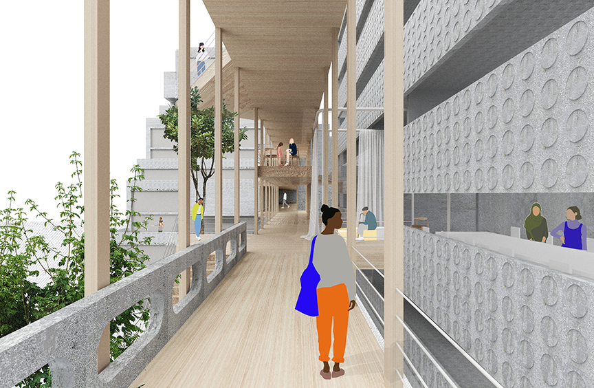
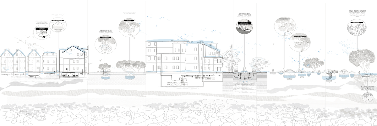
La Défense is a business district in constant transformation, but our rapidly changing climate means that its energy-intensive and resource-extractive model of construction, consumption, and demolition is no longer tenable. Looking forward, we ask: can La Défense shift toward a circular system of reuse that builds on its existing material, intellectual, and built resources? Within La Défense, the Saisons’ aging vacant Brutalist buildings, proximity to flows of construction materials, underutilized underground parking desk, residents’ and workers’ knowledge, and existing collective economic networks make it an ideal site to test a platform for reuse.
As an alternative to demolition, the vast parking deck is repurposed to store salvaged construction materials and to house repair and upcycling workshops where skilled workers transform those materials. Careful interventions into the parking deck create a cascading landscape that connects to neighboring town Courbevoie and the Seine river. The lower floors of existing buildings become sites of exchange, where people, ideas, materials, food and services recirculate within diverse alternate economies. Both old and new buildings hold spaces to envision, where circular economy organizations, green startups, and businesses experiment and where a skills training center equips workers to enter and lead this new reuse industry.
These programs are connected by the linear commons, a light framework of CLT panels and columns that contrasts with the weathered concrete of the existing buildings. The linear commons stitches together old and new buildings by fixing existing circulation issues and creating new pathways. Weaving through the site, the linear commons creates liminal zones of interactions between programs, inserts new spaces for congregation into the old, and elevates visitors to heightened relationships with the existing buildings.
LOW-ENERGY | HIGH-RISE
LOW-ENERGY | HIGH-RISE
David Ling (MArch I ’20)
Recipient of second prize in the SKYHIVE 2020 Skyscraper Challenge
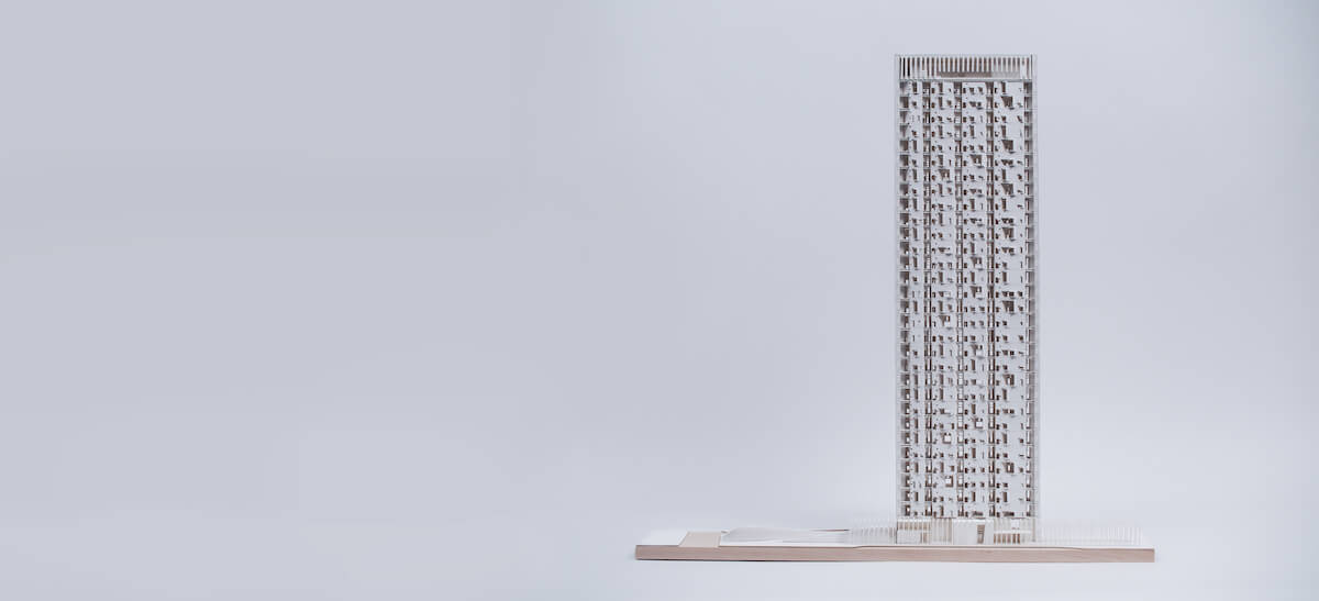
In cities with extreme climates such as Dubai, energy consumption is mostly spent on keeping spaces cool; however, this condition is reflective of a more significant problem associated with the generic all-glass developer’s condos common to the region. In Dubai, residential architecture is conceived as ‘standing capital’ instead of as site-sensitive places for dwelling. This project re-imagines the low-energy residential high rise as a holistic relationship between wind, light, shadow, and culture. It aims to expand the definition of architectural environmentalism by including place-specific aesthetic and atmospheric concerns alongside thermal regulation and energy-use.

This ambition is realized through a deep relationship with light and wind. As the carrier of both heat energy and architectural atmosphere, the light of a place has long shaped the built environment of vernacular cultures. In reference to such practices, this project engrains its relationship to the site’s light and wind into its hollow concrete structure, which acts as a passively cooled thermal mass while imbuing the dwelling spaces with a sense of thickness and intimacy. Its narrow slab-like massing orients the spaces to receive optimal prevailing winds, which both passively cool the thermal mass and provide cross ventilation through each unit.
At every step, the typical developer’s condo solutions are replaced with ones appropriate to the site and with the sensibilities that emerge when residential units are treated as places for living, rather than for selling. Shadow and ambient light characterize the atmospheric expression of interior spaces, while boundaries between inside and out are softened with respect to vernacular practices of dwelling in the liminal zone. As Dubai matures from an international playground to a diverse economy with a growing middle-class, it is due time to reconsider its built environment and what it means to dwell in this unique city. This project is a proposal for a uniquely Dubai architecture.
Snow Bank
Snow Bank
Diana Guo (MLA I ’21), Runke Luo (MLA I AP ’21), and Yuning Zhang (MLA I ’21)
Winner of a 2020 Applied Arts Award
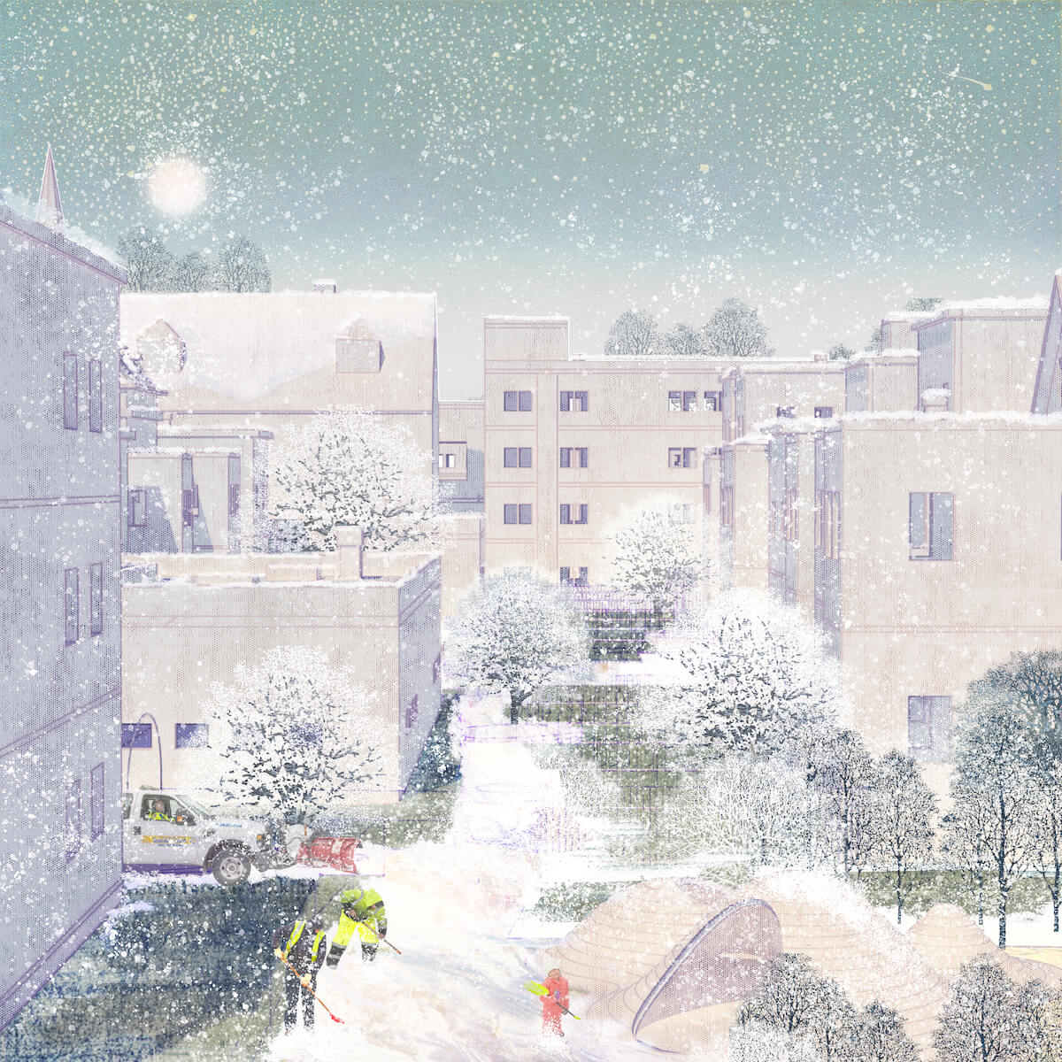
“Snow Bank” is a multi-scalar, community-based response to reuse snow for district cooling in East Boston by extending the lifetime of winter snow to be used during the extreme heat of summer. On the regional scale, snowstorms are growing more unpredictable in intensity as the climate changes while hot summers are increasingly unbearable. On the local community level, neighborhoods must come up with a rapid snow management plan that clears roads efficiently to allow equitable access to public transportation and protect their hydrological systems from severe snow meltwater contamination.
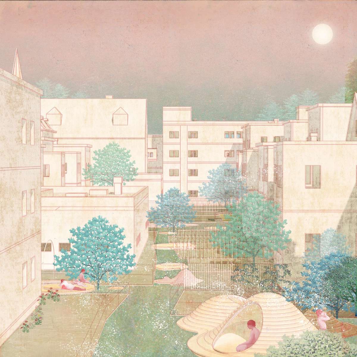
We seek to redefine the public commons through shared responsibility and redistribution of snow from a state of urban waste to one of valuable resource. Our team proposes an acupunctural network of snow storage inserted into the landscape that collect snow during cold seasons and emit cool air in the summer. The insertions correspond with above-surface landscapes that offer alternative spaces of public gathering and recreation. While each move is acupunctural, the larger effect becomes visible as a new shared commons emerges from the city fabric.
Permanence in the Temporal: Artifacts for Freedom in the Rohingya Refugee Camp
Permanence in the Temporal: Artifacts for Freedom in the Rohingya Refugee Camp
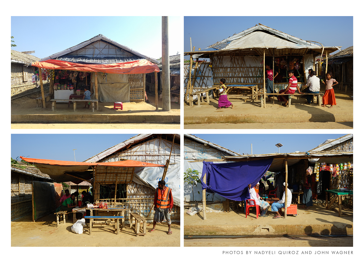
Nadyeli Quiroz (MDes ULE/MLA I AP ’20)
According to Italian philosopher Giorgio Agamben, Western politics divided the Zoe, the biological fact of life of every living being from the Bio, the social and political life in the polis. Zoe remained secluded to the domestic and private life existing within the Oikos. Agamben argues that refugees have been stripped from the political, public, and social exercise of life, the Bio and, reduced only to the naked life, the Zoe.¹
The politics of aid delivery, by design, reduce humans to a condition of bare minimum, basic biological needs, in which they have factually lost their human rights. I argue that the artifacts designed and implemented by refugees to negotiate with the bare life offered in the camps are the exercise of Bio. They are practicing a political agency within the administration of what aims to be a space devoid of any public and political life. The artifacts of negotiation of refugees are deviations within the totalitarian design of camps. These artifacts create actual cities and defy the whole narrative of the ephemerality of camps. The artifacts are exercises of freedom within the enclosure, construction of life, and the agency of those under containment.
The thesis explores how to integrate the agency, Bio, and the desires of the refugees expressed in the artifacts for freedom—looking for a planning process that will allow camps to evolve into thriving communities instead of marginalized populations.
¹Giorgio Agamben, Sovereign Power and Bare Life, trans. Daniel Heller-Roazen (Stanford: Stanford University Press, 1998), 11.
Da Yun He: Symbolism and Evolution Under China’s Leadership
Da Yun He: Symbolism and Evolution Under China’s Leadership
Frank Wen Yao (MDes ULE ’20)
For centuries, China has been known for its top-down, large-scale infrastructural projects, including the Grand Canal, the Ancient Silk Road, and the contemporary Belt and Road initiative. This thesis takes the Grand Canal as a precedent. The Grand Canal (Dayunhe), which connects Beijing to Hangzhou, has been a significant part of logistical, cultural, economic, and social infrastructure in China. This historical entity evolved over time and played a significant role in China’s civilizational progress. Despite its known importance, the ambition of the canal is enormous and is reflected in China’s technical ability and political capacity for execution. Thus, the essence of the Grand Canal lies in the idea of “Central Kingdom”—seeking ideal prosperity and Sino-centralized spatial governing strategy—the canal is beyond the concept of infrastructure and it is both the idea and the entity. As the Grand Canal evolved, it became a political symbol of Chinese civilization. However, like many other state projects initiated by China, it contains both benefits and downsides throughout time, and this lacks academic study.
Therefore, concerning future professionals and Chinese authorities, the aims of the thesis are twofold: (1) conduct a historical study of the Grand Canal with focus on the political dynamics behind the project and how this political symbol was sustained and evolved, and (2) contribute original knowledge to the field of China studies, encouraging further studies on large-scale Chinese infrastructures.
Afterlives of Orbital Infrastructures: From the Earth’s High Orbits to its High Seas
Afterlives of Orbital Infrastructures: From the Earth’s High Orbits to its High Seas
Rajji Sanjay Desai (MDes ULE ’19)
“We live in an age in which extremely expensive machines are made and installed in orbit without public knowledge, only to be spectacularly blown away and become total losses before our eyes.” ¹
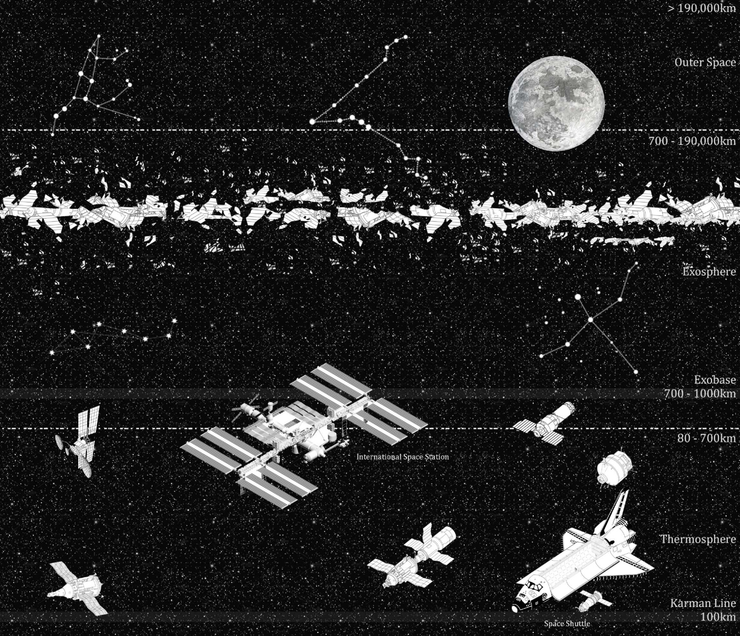
Through this thesis, I propose the concept of “false externalization.” I mobilize this within the context of the ongoing privatization of orbital space in order to characterize the present-day workings of satellite systems. I call this practice “false externalization” because, despite the seeming status of satellites as purely external to the Earth, the forms of techno-waste generated by satellite networks are in fact still subject to a material dialectic between externalization and internalization. Despite their operational lives occurring in a place more or less external to the Earth, these ostensibly externalized toxic wastes are ultimately subject to important processes of (re-)internalization back here on Earth. Significantly, these processes have dire consequences for Earth’s environments—whether built or unbuilt, human or non-human. Moreover, these so-called “externalizations” remain internal to the Earth’s life-supporting and self-sustaining systems—the ramifications of which are profoundly destructive, both socially as well as environmentally.
In an attempt to demonstrate the prevalence of this practice in the context of orbital development today, I pursue two lines of inquiry. First, I trace the legal landscape of orbital waste, foregrounding the inextricable link between the spatial politics of orbital waste and the indeterminacies that exist within the legal and legislative frameworks that govern the production of orbital space. Second, I undertake an analysis of the visual and aesthetic regimes that have resulted from these orbital waste processes in order to document how these legal ambiguities permit the materialization of uneven geographies of distribution characterized by widespread environmental and humanitarian injustices.
¹Parks, Lisa: Orbital ruins. In: NECSUS. European Journal of Media Studies, Jg. 2 (2013) Nr. 2, S. 419-429. DOI: https://doi.org/10.5117/NECSUS2013.2.PARK.
Working with Urban Informality: A Postcolonial Critique of Planning Theory based on Lessons from the Caño Martín Peña Special Planning District
Working with Urban Informality: A Postcolonial Critique of Planning Theory based on Lessons from the Caño Martín Peña Special Planning District

Samantha Saona (MDes ULE ’20)
This thesis adds to the postcolonial perspective of informality by using an empirically grounded analysis of the Caño Martín Peña Special Planning District to offer theoretical interventions. The case has been celebrated for combining a robust participatory practice and inventive planning strategies that “work with” the community. However, most previous scholarship understates the contextual specificity and the complexity of the process. Thus, I propose a critical methodology to engage with and highlight a systemic understanding of the case by using a theoretical framework that converges around risk, situated knowledge, and design politics.
This research reflects on three topics. First, the “vulnerabilization” of residents in informal areas by the political skewing of participatory processes that render the impacted populations legible and the production of government-approved technical documents that are incomprehensible to most. Second, the appropriateness of the scale chosen to work with urban informality by contrasting the scale of implementable infrastructure and design projects with alternative scales of administering policies that work with the continuous urbanization processes that lead to informality. Finally, the unpacking of economic and political “developmentalism” projects that initially caused migration into cities and their continued impact on how these spaces are perceived. In sum, this thesis proposes a de-centered and re-politicized framework to reflect on how “urban informality” is created, maintained, and perpetuated.
Land Grabs and Land Grants: Social Forestry as New Governmentality in West Kalimantan, Indonesia
Land Grabs and Land Grants: Social Forestry as New Governmentality in West Kalimantan, Indonesia
Ziwei Zhang (MLA ’17/MDes ULE ’20)
This thesis focuses on social forestry as a model of community development and democratic invention in Indonesia by interrogating its formation, formulation, and implementation. First, I reposition social forestry in the history of the democracy movement in Indonesia to explore in depth by whom, how, and why spaces for participation and decentralization are being opened and filled. Second, I argue that in the current political and legal space, social forestry, while notionally ’empowering’ local communities, has also enabled depoliticization of the previous radical, anti-capitalist, and anti-palm oil civil movements. Third, I aim to call attention to the land politics in the proximity of extractive and conservative land use, as well as in the planning institution that institutionalizes insurgent civil movements.
Inveterate Scars: Confederate Monument Removal in the New South
Inveterate Scars: Confederate Monument Removal in the New South
Ann Hunter Lynch (MLA ’19)
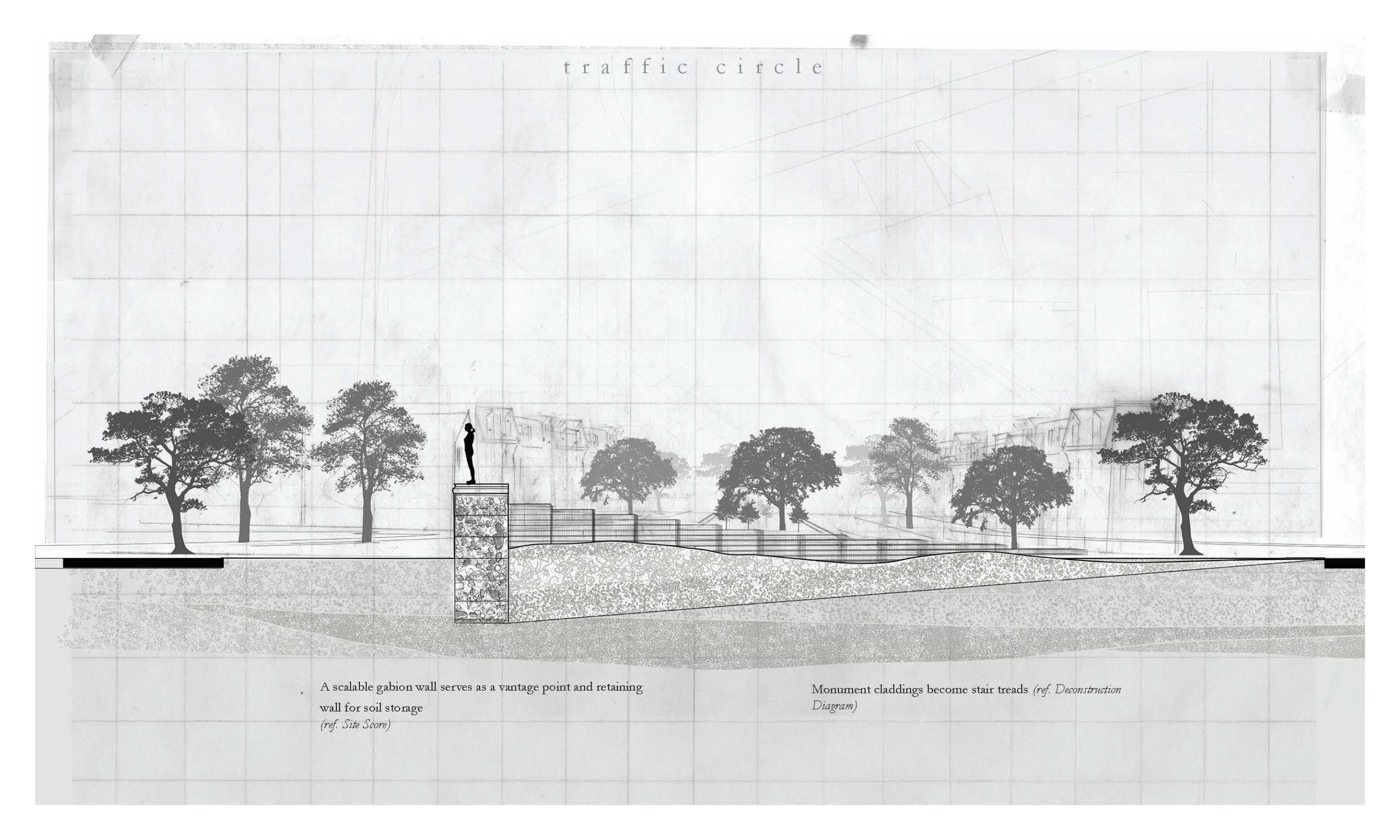
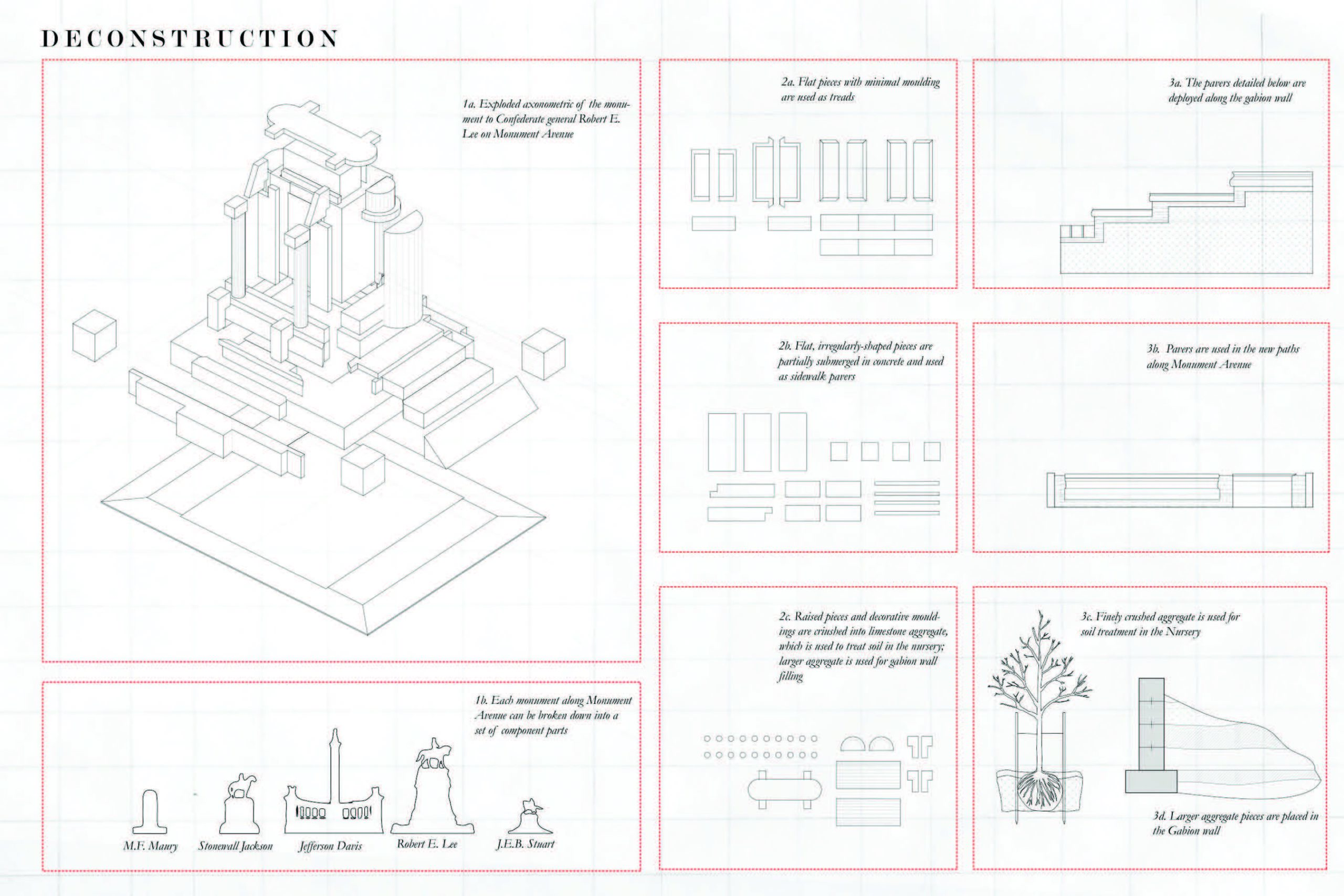
The removal of Confederate monuments as it is carried out by city and state governments typically consists of the relocation of the figurative element of the monument. The pedestal, that which most readily distinguishes the monument in the urban landscape, remains. This fracture has created a new spatial typology: the post-monument site.
The post-monument site contests the actual and perceived spatial extents of the monument, suggesting that the removal of its figurative elements does not change its performance in the landscape. As such, an exploration of the post-monument site reveals that monumentality is a system comprised of the entire urban surface; and its destruction is, therefore, dependent upon the strategic destruction of the city itself.
This project imagines a post-monument site on Richmond, Virginia’s Monument Avenue. Built in 1890, Monument Avenue established a memorial archetype in the post-bellum south as it merged transportation infrastructure with monument figure. The five confederate monuments along the avenue are situated at major intersections. As each occur at critical nodes of circulation, the monuments dictate the city’s movement– rhythms of transit, commerce — are thus transformed into acts of ritual consecration.
Consecration depends on its reverse, twinned process of obliteration, a relationship that is observable in Richmond’s construction of interstates 95 and 64. Built in the 1950’s, the interstates bisected many of Richmond’s historically black communities in a municipal “slum clearance” effort. The act effectively destroyed these communities as their inhabitants had once known them, and these areas were quickly populated with vacant lots.
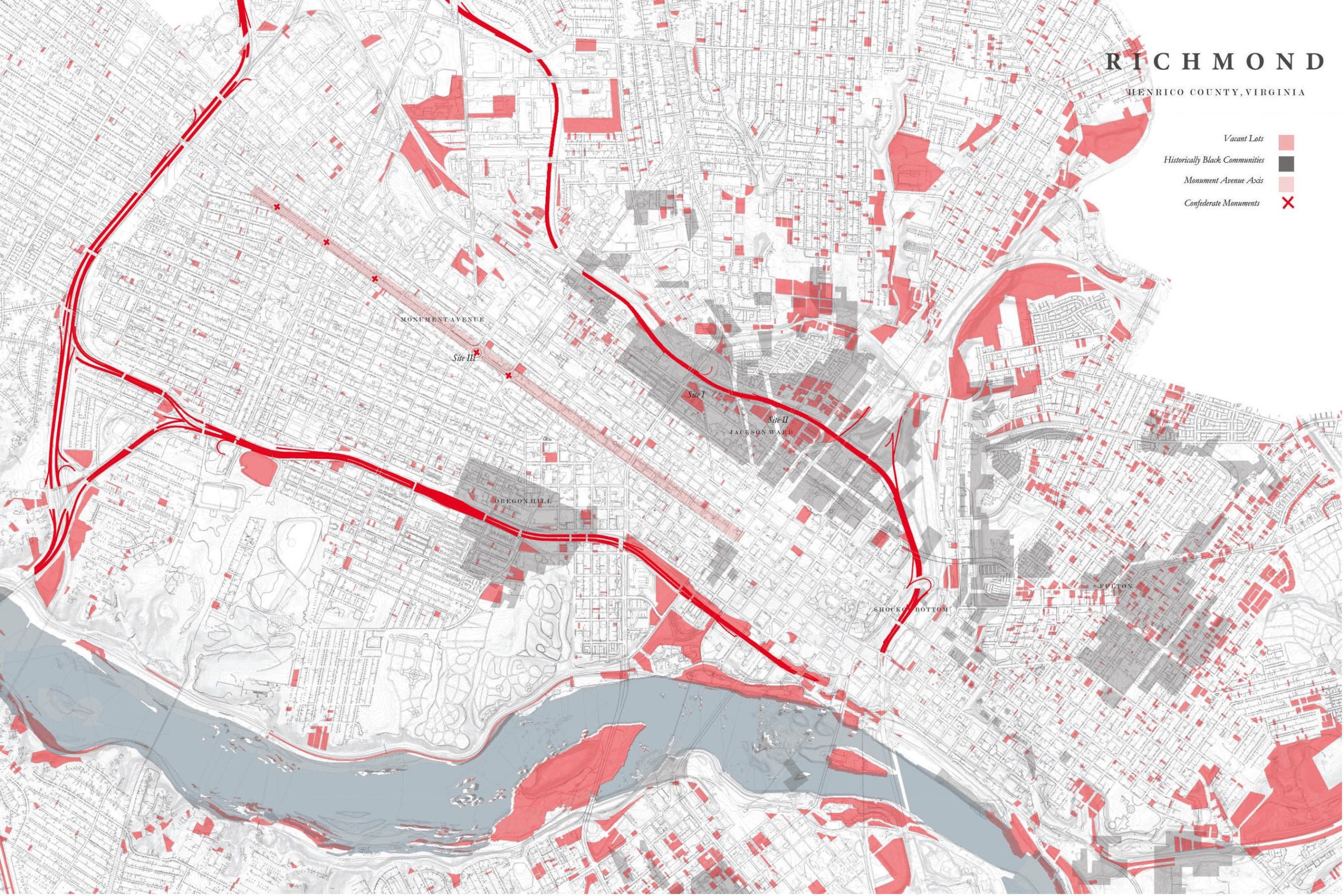
The project proposes the disruption of Monument Avenue as well as its reconstitution through a system of transfer between vacant lots and the avenue itself. Monument pedestals are dismantled and recycled as sidewalk pavers, gabion fill, and tree trench fill. The Avenue’s tree-lined medians are thinned and re-planted with nursery trees, destined for vacant lot sites.
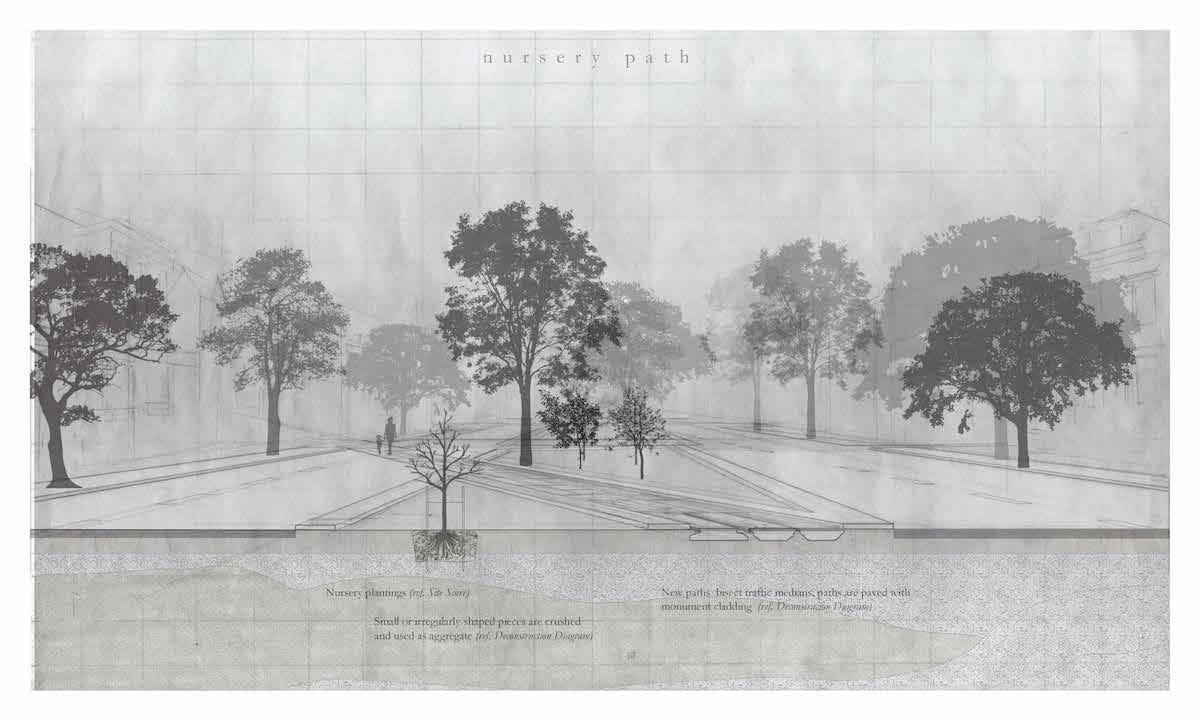
Simultaneously, vacant lots become sites of community-informed excavation. Through the material exchange between the Avenue and the excavation sites, this project proposes a means by which existing monumental infrastructure is dismantled and a new method of retrieving and experiencing history in the city is introduced.
For decades, the design discipline has been complicit in constructing the physical environment of white supremacy. The removal of Confederate Monuments, redefined as a city-wide project, calls upon designers and planners to work with Black communities to create a new memorial landscape that excavates obliterated areas and with them silenced histories.
Inveterate Scars proposes an expansive definition of monumentality and memorialization that critiques broad historical narratives, honors and amplifies local forms of memory practice, and elevates the memorial qualities of lived, every day experience.
View Inveterate Scars on Hollis .
In the Name of Heritage: Conservation as an Agent of Differential Development, Spatial Cleansing, and Social Exclusion in Mehrauli, Delhi
In the Name of Heritage: Conservation as an Agent of Differential Development, Spatial Cleansing, and Social Exclusion in Mehrauli, Delhi
Karan Saharya (MDes ’20)
I intend to study the impacts of the architectural conservation of the Qutub Minar Complex on the urban village of Mehrauli, New Delhi, because the manner in which national- and international-level preservation and planning frameworks operate reveals underlying sociopolitical conflicts and instruments of spatial cleansing. The thesis seeks to develop a new framework for the examination of “heritage” in the post-postcolonial milieu that contextualizes the designated monument within the larger urban fabric and can inform policy using a stakeholder-centric approach. I hypothesize that the appropriation of “heritage” in contemporary urban India is a tool to develop elite tourist destinations while displacing local communities, expropriating land, and reiterating colonial-era identity politics.