Priority Setting Amid the Rubble: Organizational Responses to Post-Disaster Reconstruction in Haiti
Priority Setting Amid the Rubble: Organizational Responses to Post-Disaster Reconstruction in Haiti
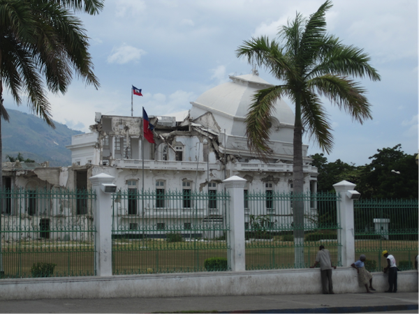
Since 2012, this project has been investigating how development organizations establish, and act on, priorities in urban, post-disaster reconstruction. It is motivated by a longstanding observation that the priorities of organizations engaged in disaster response are often unaligned. As an example, in post-earthquake Haiti, donor funding for transportation has exceeded government requests by 510%, while funding for strengthening democratic institutions has reached only 20% of the government’s target. Unaligned priorities are of concern, in part, because they can hinder coordinated action. While there is a small but established literature on organizational responses to disasters, it has largely focused on immediate disaster response, not reconstruction. Where it has addressed reconstruction, it hasn’t investigated the issue of priority setting across the diverse range of organizations increasingly engaged in this dimension of urban planning.
Recognizing that the social science community working on disasters is small and that social science theory development in this area is relatively limited, this project seeks to contribute to a more robust understand of organizational responses to urban reconstruction. It draws on detailed interviews conducted with seven categories of development organizations working in post-earthquake Haiti: intergovernmental organizations, bilateral aid agencies, large international NGOs, small international NGOs, private development contractors, Haitian government agencies, and local Haitian NGOs. Employing both quantitative and qualitative methods, the project analyzes how these different actors have established priorities and chosen to act on them and evaluates how organizational dynamics in the field of post-disaster reconstruction influence these decisions. The research seeks to inform policy by suggesting ways to improve the coordination of reconstruction efforts, an important task in a field that includes an increasingly diverse array of organizational actors.
Publications
Hooper, M. 2018. “When Diverse Norms Meet Weak Plans: The Organizational Dynamics of Urban Rubble Clearance in Post-Earthquake Haiti .” International Journal of Urban and Regional Research, In Press.
Pym, M. and M. Hooper. 2017. “Humanitarian Standards in Urban, Post-Disaster Contexts: A Study of Sphere Shelter Standards in Haiti .” Humanitarian Exchange Magazine, 69: 31-34.
Hooper, M. 2015. “Will the City Rise Again? The Contested Geography of Housing Reconstruction in Post-Disaster Haiti .” Housing Studies, 30(7): 1016-1035.
Hooper, M. 2014. “Priority Setting Amid the Rubble: Organisational Approaches to Post-Disaster Reconstruction in Haiti .” International Journal of Disaster Risk Reduction, 10: 270-280.
Hooper, M. 2012. “Post-Disaster Resettlement: More than a Question of Shelter .” In M. Mostafavi and P. Christensen (Eds.). Instigations: Engaging Architecture, Landscape and the City. Zurich: Lars Müller Publishers.
Sponsored by the Harvard Academy for International and Area Studies
Urban India Atlas
Urban India Atlas
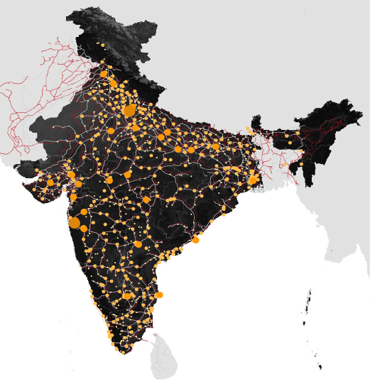
The Urban India Atlas project is a long-term critical assessment of emergent patterns of urban growth in India today. The investigation applies a range of spatial analysis techniques to better understand the logic (or lack thereof) behind urban, regional, and national development, and arrive at conclusions regarding future patterns of growth.
The study is unique in its focus on India’s large and medium- sized cities, in addition to the country’s megacities. A significant proportion of future urban growth will occur in what are typically defined as Tier II, Tier III, and Tier IV cities. Tier II cities are understood as rapidly expanding metropolitan centers with an average population of roughly 3 million residents, such as Jaipur and Lucknow. Tier III cities are defined as metropolitan areas with around 1.5 million residents, such as Asansol and Jamshedpur. Finally, Tier IV cities are characterized by a population of less than 1 million and include cities such as Bhubaneswar and Mysore.
In a class of their own are India’s world-class new towns, of which 25 are planned; one such town is Lavasa, a 25,000-acre private city currently under construction near Pune. Although many of these cities are seemingly insignificant when compared alongside Mumbai, Delhi, or Kolkata, many Tier II, Tier III, and Tier IV cities are advancing rigorous development plans and stand to see significant population growth in the coming decades. Other small and medium- sized cities are struggling to establish clear growth strategies or attract new investment, and are in danger of being left behind. The Urban India Atlas will catalog and account for these emergent trends of urbanization, with particular attention given to rapidly growing medium-sized cities.
Urban Theory Lab
Urban Theory Lab
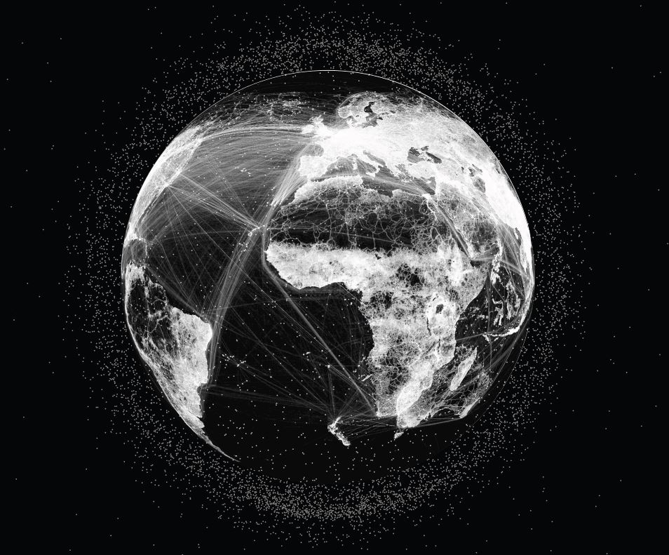
In the early 1970s, Henri Lefebvre put forward the radical hypothesis of the complete urbanization of society. This required, in his view, a radical shift from the analysis of urban form to the investigation of urbanization processes. The Urban Theory Lab-GSD builds upon Lefebvre’s approach to investigate emergent sociospatial formations under early twenty-first century capitalism.
Our research starts from the proposition that inherited frameworks of urban knowledge must be radically reinvented to illuminate emergent forms of twenty-first century urbanization. In contrast to the urban/suburban/rural distinction that has long underpinned the major traditions of urban research, data collection and cartographic practice, we argue that the urban today represents a worldwide condition in which all political-economic and socio-environmental relations are enmeshed, regardless of terrestrial location or morphological configuration. This emergent condition of planetary urbanization means, paradoxically, that even spaces that lie well beyond the traditional centers of agglomeration—from worldwide shipping lanes, transportation networks and communications infrastructures to resource extraction sites, alpine and coastal tourist enclaves, offshore financial centers, agro-industrial catchment zones, and erstwhile “natural” spaces such as the world’s oceans, deserts, jungles, mountain ranges, tundra and atmosphere—are becoming integral to a worldwide operational landscape for (capitalist) urbanization processes.
Through a conceptual distinction between concentrated urbanization (agglomeration) and extended urbanization (operational landscapes)—developed in collaboration with Prof. Christian Schmid of the ETH-Zurich—we aim to investigate the historical geographies of the capitalist urban-industrial fabric in ways that supersede inherited metageographical binarisms while opening up new sociological, cartographic and political perspectives on the contemporary global-urban condition. Our work combines conceptual and representational experimentation, theory-driven research and research-based pedagogy, as well as various forms of outreach and events programming within the Harvard-GSD community and at scholarly conferences and workshops around the world.
Selected publications
Neil Brenner and Christian Schmid. “Towards a new epistemology of the urban?” CITY. 19(2-3), 2015. 151-182.
Neil Brenner (editor), Implosions/Explosions: Towards a Study of Planetary Urbanization. Berlin: Jovis, 2014.
Hillary Angelo and David Wachsmuth. “Urbanizing Urban Political Ecology: A Critique of Methodological Cityism.” International Journal of Urban and Regional Research. 39(1), 2015. 16-27.
Daniel Ibañez and Nikos Katsikis (editors). New Geographies 6: Grounding Metabolism. Cambridge: Harvard University Press, 2014.
Neil Brenner. “Open city or right to the city?” TOPOS: The International Review of Landscape Architecture and Urban Design. 85, 2013. 42-45.
Principal Investigator
Professor Neil Brenner
Collaborator(s)
Professor Christian Schmid, ETH-Zurich
Kumbh Mela
Kumbh Mela
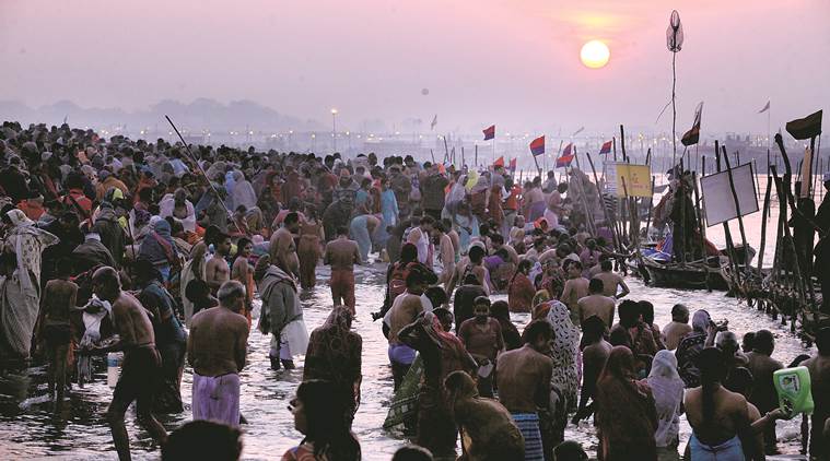
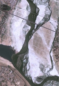
The Kumbh Mela is a Hindu religious festival that occurs every twelve years at the confluence of the Ganga and Yamuna Rivers in the city of Allahabad. Since its inception early in the first millennium CE, the Kumbh Mela has become the largest public gathering in the world; today it draws tens of millions of pilgrims over the course of a few weeks to bathe in the auspicious rivers. The Mela provides a forum for both individual and collective expressions of faith as pilgrims, religious teachers, and followers of monastic orders converge from all parts of India.
The Mela inspires interdisciplinary research in a number of complementary fields. Pilgrimage and religious studies, public health, design, communications, business, and infrastructure engineering converge at this festival, producing a complex atmosphere that can be understood through rigorous documentation and mapping, both on-site and in post-field processing. We consider the Kumbh Mela to be a case study, or prototype, for a concept we would like to call the pop-up mega-city. This spatial model can be extended to situations outside of religious pilgrimage: understanding the spatial, social, and logistical elements of the Kumbh Mela through interdisciplinary research will allow us to propose the deployment of these systems in a variety of places and situations, in particular camps for refugees of war and natural disasters.
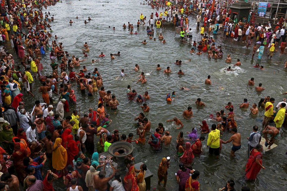
The underlying structure of the Mela emerges in the creation of a temporary city to house its many pilgrims. This city is laid out on a grid, constructed and deconstructed within a matter of weeks; within the grid, multiple aspects of contemporary urbanism come to fruition, including spatial zoning, an electricity grid, food and water distribution, physical infrastructure construction, mass vaccinations, public gathering spaces, and nighttime social events. The ultimate goal of the pilgrims is to bathe at the convergence of the rivers: even this act is organized into a larger procession, where pilgrims are given specific times and opportunities to bathe based on their social status. When the festival is not in session, the ground on which the city sits is used for different forms of agriculture.
Visit Mapping the Kumbh Mela at the Harvard University South Asia Institute.