The W
The W
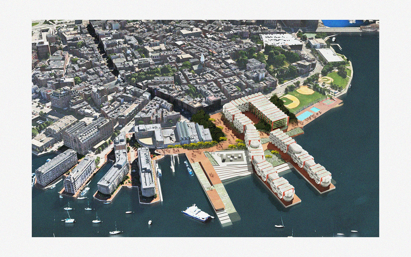
Van-Tuong Nguyen (MDes REBE ’18), Carla Wijaya (MAUD ’18) and Maxime Faure (MAUD ’18)
The proposed W mixed-use housing development on Boston’s North End waterfront bridges old and new communities in the city’s densest historic neighborhood. It provides housing for an increasingly transient population—including young newcomers and single householders. It repurposes land in a land-scarce neighborhood to create an urban park connection to and across the waterfront.
The parcel, currently owned by the United States Government and occupied by the United States Coast Guard, presents an opportunity to transform a disruption in the urban experience of the harbor walk to a public amenity. Through the United States General Services Administration (USGSA) land disposition strategy, the parcel may be reinvested for a higher and better use; the existing outfit may be relocated and consolidated with the sister location on the East Boston waterfront.
In return for the land subsidy, the W development provides a more urban and resilient waterfront design that would alleviate the housing shortage in the North End and provide an accessible platform of neighborhood vitality. The W breathes fresh life into the North End, providing neighborhood amenities in addition to micro-housing rental units, for-sale condominiums, restaurants, and retail—all united on an urban park that increases the value of the site.
The financial strategy takes advantage of housing and entitlement subsidies and is supplemented by condominium and parking structure sales. Our financial analysis illustrates that the project’s feasibility largely depends on the land cost—that while a conventional unsubsidized development yields fair returns, a subsidized public-private model yields both better financial returns and higher net public value.
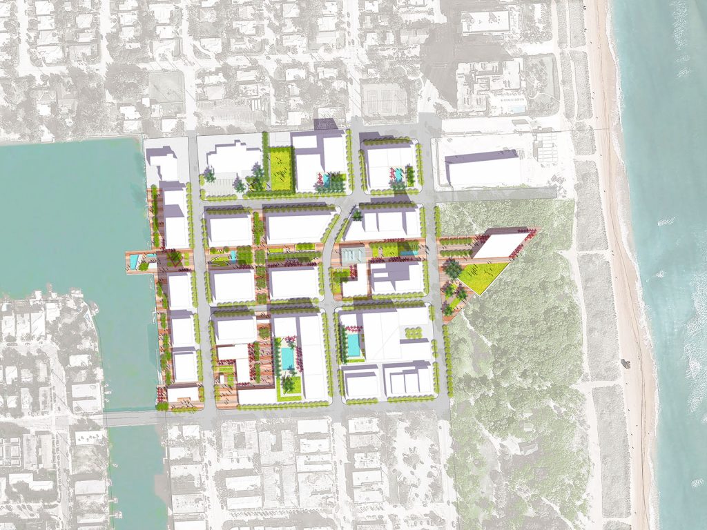
NoBe Nexo
NoBe Nexo
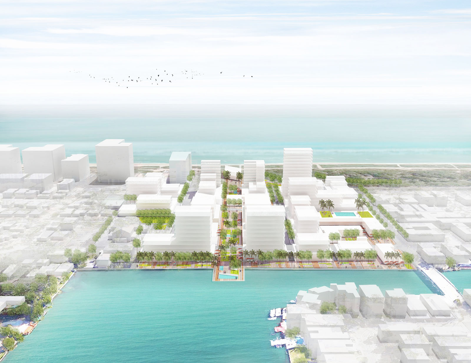
Lisa Hollywood (MAUD ’17), Chris Merritt (MLA I ’17), Patricia Alvarez (MDes REBE ’18) and Lindsay Woodson (MDes RR/MUP ’17)
NOBE NEXO is a redevelopment project in North Miami Beach, Florida, integrating a mix of uses into a cultural and culinary hub that through a performative density strategy provides a model of resilience to climate change and gentrification. The project implements immediate mitigation and prevention measures for pressing environmental risks as well as delivering assets relevant to the current residents and local character of the neighborhood.
Located at the boundary between the affordable neighborhood of North Beach and the upscale neighborhood of Surfside to the north, development pressure is acute at this location. Nobe Nexo creates a nexus between the disparate neighborhoods and protects the residents of North Beach from wholesale displacement.
The current North Beach community is economically disadvantaged compared to its neighbors, and the population is largely Hispanic. This project also aims to ameliorate the food insecurity of the neighborhood and frames the development as a culinary destination for all income levels.
The 18-acre site includes 1.5 million square feet of retail, hospitality, institutional and residential uses, offering an array of products and units to balance the requirements for affordability and luxury within 3 phases over a 15 year investment horizon. The land assembly is facilitated by a clustering of publicly-owned land at the site, with 58% of the parcels owned by either of the city (West Lots) or institutions (elementary school, senior housing, and church).
In order to afford the resiliency measures required for the area, on top of the subsidies applicable to the development, the Adaptation Action Area seeks to involve third party capital through innovative financing alternatives. The level of investment calls for an enhanced density or “Performative Density” within a private-public partnership structure to ensure the feasibility of public benefits. The massing responds to the existing context with height along the bay and Collins Avenue, and steps down toward single-family housing to the south. Neighborhood features are preserved within the redevelopment, with the preservation of specific historic buildings and the continuation of existing institutional uses.
The main artery of the development, Nexo Paseo, is an open space promenade connecting the bay and the ocean, and is the focal point of food-related programming and community vitality. It performs as the food hub, job center, economic driver, and stormwater management system that functions as the foundation of the development.
Ambiguous Pictures: Dynamic Projections of Non-Euclidean Space
Ambiguous Pictures: Dynamic Projections of Non-Euclidean Space
Iman Fayyad (MArch I ’16), Irving Innovation Fellow, 2016
The art historian Ernst Gombrich reminds us that the 2-dimensional image is ambiguous. It represents infinite possibilities of 3-dimensional Euclidean configurations. Rather than designing the pictorial space to represent a certain reality according to the conventions of drawing, the challenge here is to design a 3-dimensional reality that responds to a fixed constraint—a planar picture plane—forcing physical objects to morph in deference to it. Illusions work because they manipulate our established understanding of well-acquainted realities (in our built environment, this is largely orthogonal Cartesian geometry). By accommodating the hyperbolic distortions of reality in visual space, our spheroidal field of vision is embodied in forms in real space to appear to look “correct,” or familiar, from certain points. From all other (infinite) points in space, those same objects appear to liquefy, creating the illusion of constant deformation of form in real time. Here, perspective provides cognitive perceptions of objects (in pictorial space) with topological and typological identities different to those belonging to the same objects in reality.
Plywood Napkins: Revisiting the Fold through Recursion
Plywood Napkins: Revisiting the Fold through Recursion

Alexander Timmer (MArch I ’16), Irving Innovation Fellow, 2016-2017
Plywood Napkins explores the possibility of formulating a methodology for design through the deployment of a simple, repeated cutting operation. Each piece is cut, the cutoffs are then flipped and glued back together. The object then settles per its natural tendency and the process is repeated. As the surface is edited, it no longer rests flat on the table. A nominal 20-degree cut, set by a fixed saw, varies relative to the surface’s global and local permutations at any one time.
The resulting surfaces exhibit both negative and positive feedback, as the subsequent cuts cause the surface to fold in onto itself. While its footprint shrinks, its mass is conserved. At the same time, each cut and flip causes misalignments, which grow with each higher-order cut. The designer engages continuously in a dialogue between continuity and error, local expression and global form, and design intent and material intelligence.
Design for Recovery: Fieldwork in Nepal & Somalia
Design for Recovery: Fieldwork in Nepal & Somalia
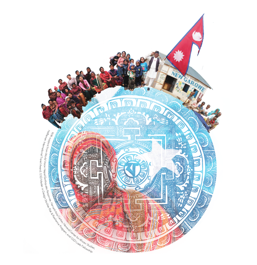
During January of 2016, a group of GSD students travelled to Nepal and Kenya, to examine post-disaster recovery in Nepal (after the 2015 earthquake) and Somalia (after 2012 drought and conflict) embedded with project teams from World Vision International. This exhibition is the product of this experience, documenting progress, successes and challenges. Students were able to examine implementation of projects, field realities, and institutional approaches of how built environment issues are being tackled on the ground after a disaster, and question the role of design professionals and how they can better support community needs. Fundamentally, the role of design was examined, and how it can support and be integrated for better recovery outcomes.
Team
Nepal Fieldwork by Justin Henceroth (MDes ’17), Oscar Natividad Puig (MDes ’16), Omar De La Riva (MUP ’17), Illika Sahu (MUP ’17), Ashley Thompson (MDes ’17), Jeronimo Van Schendel (MArch ’16); Somalia Fieldwork by Carlyn James (MDes ’17)
Brett Moore (Loeb Fellow ’16), Project Advisor
Exhibition
A multimedia exhibition speculating on the experience of field-based design research in Nepal & Somalia was held from April 21, 2016-April 15, 2016 at the Harvard Asia Center. Featured work included research, drawings and sketches, geospatial and conceptual cartography, and photography in order to speculate on risk and resilience, disaster assessment, disaster response, recovery, and rehabilitation as grounded in the contemporary urban condition.
Support
With support from World Vision Nepal Earthquake Response, Harvard Asia Center, Harvard Center for African Studies, Heffernan International Travel Award, Harvard Graduate School of Design Master in Design Studies Risk & Resilience Program, and Harvard Graduate School of Design Loeb Fellowship.
Mobilizing Habitations: Re-Imagining Nomadic Architecture in the Sub-Saharan Sahel Region
Mobilizing Habitations: Re-Imagining Nomadic Architecture in the Sub-Saharan Sahel Region
Aman Singhvi (MDes ’16)
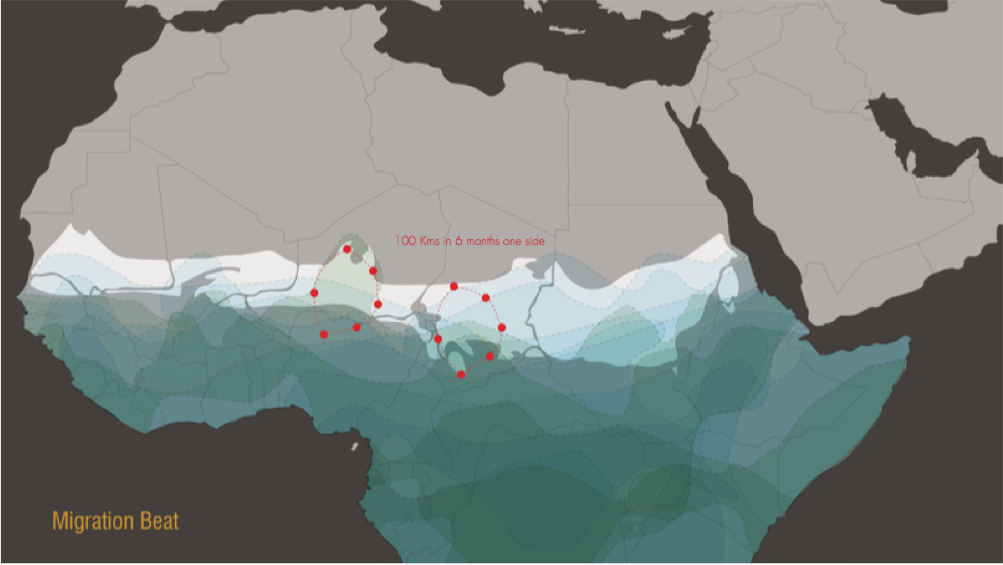
As land is increasingly commoditized with an upsurge in population, it’s not hard to imagine that some people will be forced into the harsh, uninhabited landscapes to survive. In the context of adaptability and survival, this project aims to examine the concept of Mobility and the possibilities and constraints enabled by it. A nomadic community in the shifting ITCZ zone of Africa is reimagined in terms of adaptations in architecture and migration. In contrast to the present ideology of mobilizing resources to concentrate them at consumption-heavy centers, the proposition is to mobilize communities to move in sync with the natural resource cycles.
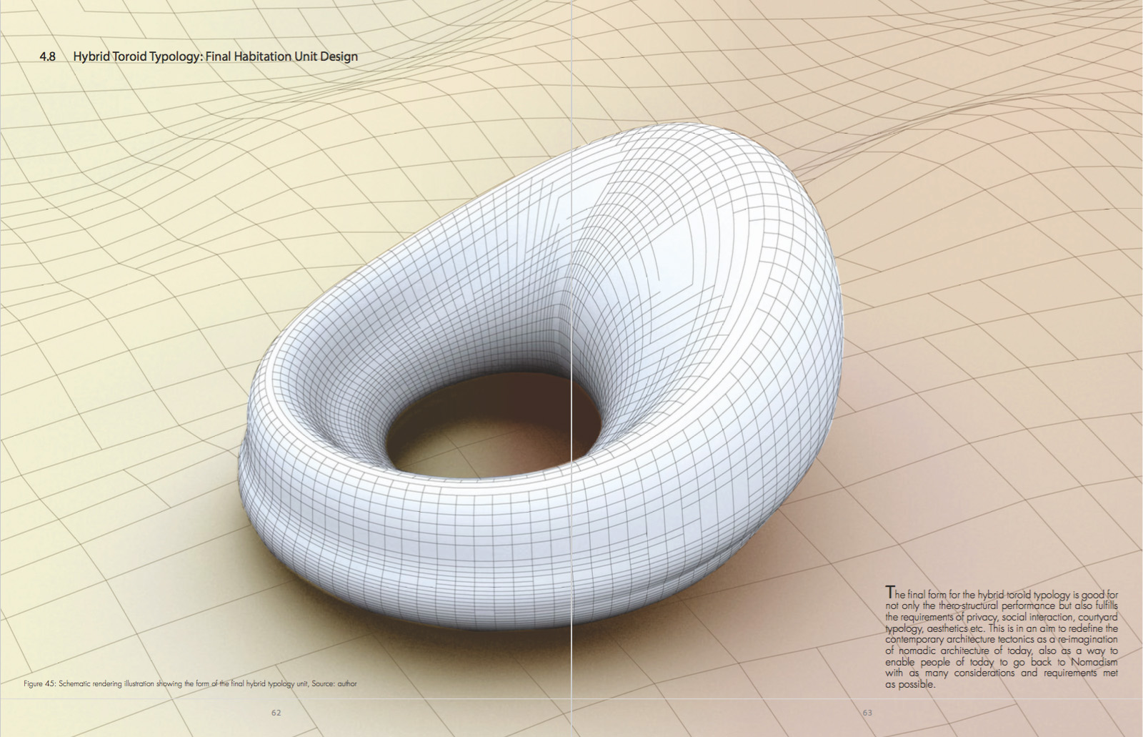
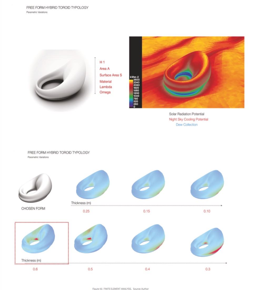
The emphasis becomes on optimizing structure, thermal regulation and migration under the constraints of slow-mobility. The aim is to design a mobile dwelling unit, which is adaptable and which harvests solar energy. Doubly curved shells are imagined as the structural system for this habitation unit while the geometry and material parameters are computationally tuned for thermal performance. For this combined thermal and structural approach, the nite element analysis and form-finding method from Millepede1 (developed by Panagiotis Michalatos and Sawako Kaijima) is combined with the Thermal Resonator concept2 based on the work by (Holford and Woods 2007) 3 to develop a Thermo-Structural Form Finding Methodology for Shell Structures. This gives a matrix of solutions for the unit design with only as much weight as necessary for desired characteristics. At the same time, the possibilities of capturing solar energy and using radiative cooling power of the night sky are being explored for resource maximization. The final design is a cumulative output with sensitivity towards spatial, social, thermo-structural, material, temporal and mobility requirements.
In Search of Authenticity: A Case Study of San Francisco Chinatown
In Search of Authenticity: A Case Study of San Francisco Chinatown

Yunjie Li (MDes ’16)
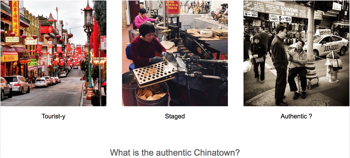
A city or neighborhood is attractive because of its unique and distinctive culture that people applaud as “authentic”. This thesis studies the case of San Francisco Chinatown on where the “authentic” Chinatown experience is found, and specifically how is it different for three groups of people: tourists, San Francisco residents and locals from the area. Using geo-tagged Instagram data, users were first grouped according to the time pattern of their local posting activities. Next a series of analytic and visualization tools, including kernel density and the DBSCAN algorithm, were used to analyze the spatial footprint and social media content of each group. An additional resident survey was also conducted to provide an alternative local perspective for comparison. The results validated that people tend to experience the cultural space of San Francisco Chinatown differently depending on their relative role to the place. Also the potential risk of missing certain demographics (the locals in this case) in such analysis was discussed. Finally, three urban planning strategies were recommended to the San Francisco Chinatown community for the social media age.
The research implications are twofold. First, by arguing that the “authenticity” is subjective to the individual’s personal experience and background, it calls for more flexibility and extensibility in decision making on cultural conservation and community development. Second, by constructing a standardized workflow to analyze large volume of geo-tagged social media data, it hopes to explore new possibilities of utilizing big data to answer urban research questions previously difficult to quantify or model otherwise.
Territories of Flux
Territories of Flux

Gloria Chang (MDes ’18), Dení López (MDes ’18), Ruth Chang (MArch ’17)
Our project addresses the material transformation and flux of our built world, as well as the way they reconstruct the concept of land and water in human settlement and urbanization.

THE INHABITABLE VOLUME
The Earth is a finite sphere defined by the amount of particles it can hold to its center, each layer compressing the one beneath it. The surface we inhabit transforms into a volume as we build up, out, and sometimes, down, over land and one day, sea. How we build increases in ecological impact in proportion to our population, as we slowly fill up this inhabitable volume.
TRANSFORMING DENSITY AND MATERIALITY
To show human impact, building materials are mapped by density over time, graded concentrically from the core of the Earth, and travel counterclockwise. Natural materials are gridded and isolated, drawn out by humans, altered and brought to the surface to build our civilizations. As we build, we change our materials; we make them denser and lay them on the surface of the Earth in opposition to the natural layering of densities, thus altering the permeability of the crust and disrupting the flow of water.

RE-CONCEPTUALIZING WATER-BASED GROUNDS
In the plots of Mexico City and Toledo, Ohio, both the city and region are the result of the vivid and insistent cultural imaginations of its conquerors and inhabitants as they separated water from the land. Our project questions the predominance of land over water in telling the story of a place, tracing the process and ultimate crisis by which settlement has drawn boundaries, distinguished, channelized, and extracted water apart from the idea of ‘wetness’ in the landscape as a resource.
Groundedness as Risk: Adaptive Strategies for Ground Failures in Seattle
Groundedness as Risk: Adaptive Strategies for Ground Failures in Seattle

Arthur Leung (MDes ’17)
This thesis argues that the conditions of the ground—the mutable material conditions of the earth—are fundamental to both understanding the full implications of geologic risk and engaging in responsive design practices in an unpredictable context.
“Groundedness” implies a sense of stability and permanence. Our reliance on the presumed fixity of the earth under our feet has led us to lose sight of its dynamism. From macro stress-releasing tectonic readjustments to micro fluvial sediment transport, these natural processes are part of an adaptive cycle that oscillates between stasis and “creative destruction.” Ground modifications for urban development, which are predisposed to engineering resilience, have exacerbated disasters by attempting to fix, control and manipulate ground without considering the recombinant and indeterminate systems that contribute to ecosystem resilience.
Seattle is the largest city in the Pacific Northwest, a region due for its “Next Big One”—a megathrust earthquake in the Cascadia Subduction Zone. This high-magnitude perturbation would occur in an urban context already sensitive to natural hazards, such as landslides, liquefaction and sea level rise. This project explores how the city can survive the destructive forces of ground failures while respecting the natural processes that are constructive forces necessary for our environment. It uses sediment as a resource that should be conserved for ecosystem health and allocated to adaptive strategies, amongst other earthwork projects. Organized into three parts, Part I assesses risks for multiple natural hazards, Part II tells the story of the evolving ground of Seattle, and Part III speculates on potential adaptive strategies.
SELENOGRAPHY: The Celestial Sovereign
SELENOGRAPHY: The Celestial Sovereign

Genevieve Ennis Hume (MDes ’17)

Baudrillard writes that “it is no longer a question of either maps or territories. Something has disappeared: the sovereign difference, between one and the other, that constituted the charm of abstraction.” In the case of the Moon, this loss is literal, as the lunar map cannot delineate sovereign land.
The Outer Space Treaty was adopted by the General Assembly of the United Nations in 1967 as the framework for international space law. Article II, critical to territorialisation, states:
“Outer space, including the Moon and other celestial bodies, is not subject to national appropriation by claim of sovereignty, by means of use of occupation, or by any other means.”
While the Treaty limited imperial reign by deeming the exploration and use of space as the “province of all mankind”, it failed to address land tenure in relation to resources. The Moon Treaty followed shortly thereafter in an attempt to limit both military and commercial activity in space in accordance with the United Nations Charter. Elaborating on the Space Treaty, it necessitated all interventions as exclusively peaceful in nature and prohibited the exploitation of celestial bodies and their resources. The Moon Treaty is considered to be a failed initiative, however, as it has only been ratified by 7 states, none of whom have their own manned space exploration programs. While current space law prevents celestial state control, sovereign influence remains. The door has been left open for imperialism rooted in surveying, extraction, and finance.
In 2008, trace water molecules were identified in lunar volcanic matter that had been recovered during the Apollo missions, spurring the mapping of lunar minerals. The ability to mine lunar ice is seen as key to a sustained human presence in space. In addition to yielding oxygen to breathe, the water is needed for human consumption, cooling, radiation shielding, and rocket propellant. Regolith, lunar soil, holds an estimated 1.6 billion liters of water ice, resting at the lunar poles.
This project seeks to add to a body of knowledge the geopolitics of extraction, with the moon at its center.