Contemporary Developing Countries: Entrepreneurial Solutions to Intractable Problems (at FAS)
What problems do developing countries face, and how can individuals contribute to solutions rather than awaiting the largesse of the state or other actors? Intractable problems – such as lack of access to education and healthcare, forced reliance on contaminated food, deep-seated corruption – are part of the quotidian existence of the vast majority of five of the world’s seven billion people. Developing societies suffer from what we refer to as ‘institutional voids’ that make organized activities of all sorts difficult; think of the mundane but important physical infrastructure that allows us to get to work or school in the developed world, as well as our access to higher-order institutions such as the availability of information at our fingertips or the security of the rule of law. The course demonstrates that reflecting upon the nature of the developing world’s intractable problems through different lenses helps characterize candidate interventions to address them. The scientist’s hypothesis-driven and iterative experimentation, the artist’s imagined counterfactuals through putting oneself in others’ shoes literally and theatrically, and the planner’s top-down articulation of boundary conditions, all tailor the ultimate solution. The course will also examine entrepreneurial solutions that have sought to address challenges posed by the Covid-19 pandemic and by society’s response to it.
Prerequisites: None.
Jointly offered courses: Faculty of Arts and Sciences (FAS) as GENED 1011.
Open to cross-registration for students from other schools and universities. May accept a limited number of auditors, pending instructor approval.
Informational sessions during shopping period are scheduled on August 18 at 2:00 and 2:30 EST and August 20 at 2:00 and 2:30 EST. The zoom sessions can be accessed via the liks below:
Preview Session 1 Tuesday, August 18 – 2:00 pm – 2:30 pm EST
Preview Session 2 Tuesday, August 18 – 2:30 pm – 3:00 pm EST
Preview Session 3 Thursday, August 20 – 10:00 am – 10:30 am EST
Preview Session 4 Thursday, August 20 – 10:30 am – 11:00 am EST
AFTER THE PARTY – A New Open Fair [M2]
How can the empty spaces left over by a globally receding exhibition industry be converted and opened to the surrounding city without blocking new models for exhibition and trade in the future? This studio project deals with the general imminent architectural transformation of huge areas around the world, and specifically with the ongoing development of Basel, Switzerland.
Since 1921 Messe Basel, home of globally renowned events such as Art Basel and the watch and jewelry fair Baselworld, has been a dominant feature in the city center. A series of large-scale, privately owned buildings and exhibition halls are grouped around a public exhibition square; a cluster that has been built and rebuilt over the last 99 years. The most recent addition in 2013 by Herzog & de Meuron.
In recent years, however, the fairground and the exhibition business as a whole have experienced a steady decline, now rapidly aggravated by the global COVID-19 pandemic. As fewer exhibition days will be put on in the future, this 120,000-square-meter mostly public area in the middle of the city risks becoming permanently empty. This studio will thus work on the peripheral transformation of an inner-city environment defined in the last century by hundreds of thousands of international visitors and halls filled to the brim with exhibitions and other events.
While the fairs may be shrinking, the city of Basel is experiencing a rapid population growth. In light of this situation, its already low residential vacancy rate coupled with a foreseeable increase in the rental prices is likely to become a social threat for both Basel?s inhabitants and newcomers. In order to deal with this situation, the municipality implemented several inner-city densification strategies.
The students will be asked to design a housing block prototype on the site of the current exhibition Hall 3. The project should be challenging the idea of big mono-functional areas and explore the potential of a flexible and cross-functional urban block. All projects should be able to confront the uncertain future of the fair, while exploring new trajectories for the transformation of the area and its users.
The students works will contribute to the ongoing discussion about the site?s future use, since the city of Basel has recently bought two halls (including Hall 3) from the privately owned holding company. The question will be how to add new programs to the remnants of Messe Basel, an institution which is about to change drastically, but will remain a significant economic and urban factor in Basel and Switzerland.
Note:
The studio will be held via Zoom and Miro meetings. Simon Frommenwiler, Simon Hartmann and Tilo Herlach will be available Tuesday 02:00 PM – 06:00 PM and Thursday 02:00 PM – 06:00 PM ET. Tuesdays will be used for group pin-ups and input lectures and Thursdays for
individual crits.
The instructors will also be available to account for missed time upon request.
At the beginning of the course, students will be provided with research about the context as well as a short movie and video walks to grasp the characteristics of the site as fast as possible. Moreover, along with the normal studio schedule with the instructors, the students will have the possibility to meet and exchange with key players such as representatives both from Messe and Basel's municipality.
s
GSD students may view additional information on option studios:
Schedule for Zoom Q&A sessions
Movements [M2]
“Walking, in particular drifting, or strolling, is already – within the speed culture of our time – a kind of resistance.” – Francis Alÿs
MOVEMENTS explores the animate body as a locus of knowledge and architectural capacity. We carry personal memories, physical and emotional stimuli, and other deep ancestral knowledges within our selves. Our bodily actions and proprioception in space contain multitudes of awareness, some of which we can also articulate with words, and others that remain perceptual sensations alone. In this course, you will interrogate movement as a form of kinetic knowledge through dwelling in keen observation on the active subject in space.
Our world is experiencing a series of upheavals — climatic, social, and political — within which everyday people are running, standing, marching for what they believe. A MOVEMENT, too, is a collective action, the most outward demonstration of which is putting your body in the public realm for a cause. We will focus on the modality of walking as a body action of particular political resonance. People the world over have utilized walking as a form of resistance — walking carries legacies of hope, transformation, meditation, spirituality, opposition, ritual, and the forces of change. We center as our subject not the city’s passive grifter, the flâneur, but instead someone willing to proclaim, intervene, and continually maintain their right to exist within the city at all.
As an act of translation, architecture creates notations, marks, texts, and documents that represent something else. Like a musical score, various notes combine to form sections of experience, fragments suspended in media and time. Our documents speak most loudly and broadly when built, after the representations are interpreted and made real as 3-dimensional form. MOVEMENT, then, speaks to the division of this notational work, namely the tripartite structure of this course as we traverse from Walking to Drawing to Building. Students will be encouraged to take walks and produce artifacts (short films and drawings) that serve as remembrances of these activities. This source material will inform designs for a three-dimensional architecture developed in the latter half of the course.
Our meetings will be guided by participatory activities, guest lectures, reading discussions, and collective critique regarding the artifacts made, acknowledging that architecture is a practice in a continual state of becoming. Jennifer will be available for all class sessions, which will meet T/Th from 2-6pm EST.
GSD students may view additional information on option studios:
Schedule for Zoom Q&A sessions
Urban Design for Planners
Course Objectives
This seminar course introduces physical planners to the approaches, techniques and tools of urban design necessary to structure the spatial and dimensional relationships of the built environment. Through an individual, Boston-based project, students will be required to give spatial definition and form to an urban district through the elaboration of streets, block and building morphologies, open space networks and typologies, and urban design guidelines. This course complements the first year Core Urban Planning Studios by concentrating on the design of urban spaces – informed by but independent of – the demands of quantitative analysis, decision-making frameworks, economic forecasting or the specifics of plan implementation.
Students in this class will learn urban design strategies for integrating form and program into a framework for research, collaboration, and communication. Students will gain familiarity with the technical tools and representational techniques essential for planners to portray development scenarios.
Methodology
The parameters for the site and program will be investigated at the outset of the course in order to begin with the investigation of urban form directly. The class will develop a spatial analysis of specific sites including but not limited to block patterns and parcelization, circulatory systems, open space characteristics, and relevant regulatory restrictions – easements, waterway setbacks, etc. Working individually, students will then create concept plans for specific interventions that will be elaborated throughout the remainder of the semester. The class will review urban design approaches for similarly scaled redevelopment projects, identifying relevant case studies from a range of urban design and planning practices. Students will develop their plans through the production of an urban design presentation board or boards that will include a street network plan, a public realm plan, a taxonomy of building types, three dimensional modeling of height and setback requirements and perspectival views conveying character. Techniques of representation will be customized by each student to align with their specific project approach in an acknowledgement of the relationship between representation and spatial or programmatic ideas.
Structure
The class will meet once per week, combining lectures, discussions and design reviews of individual students’ work. Grading will be based on successful completion of the urban design document described above. This course is primarily intended for first and second year planning students enrolled in the MUP program. Students outside this program may gain access to the class with permission from the instructor.
Note: the instructor will offer live course presentations on 08/31, and/or 09/01. To access the detailed schedule and Zoom links, please visit the Live Course Presentations Website.
Healthy Places: COVID-19 and Cities
The connections between health, well-being, and place are complex. This class uses COVID-19 as a starting point for examining how to make healthier places. It examines the health situation in different kinds of places and among key population groups. It explores how to assess environments and how to make changes that reflect knowledge from multiple disciplines and from local people.
The class will be divided into two streams—input and action. In the input part of the class students will engage readings, interact with authors, and discuss ideas. In the action component individuals and groups of students will develop an approach to improving well-being and health in places. These projects may engage clients or be more speculative.
Throughout the class students will also reflect on some larger questions. Can the ways that places are planned and designed improve health? What are the key health issues that should concern those in planning and related fields? Does the work of incorporating health issues into planning and design processes always add value? Is evidence-based practice really an improvement over business-as-usual? What is the relationship between the different approaches to incorporating health into planning and design practice: health assessments, built projects, regulations and policies, interagency coordination, and programs to change how places are used?
By the end of the course a student will be able to:
– Recognize the many determinants of health including, but not limited to, built environments.
– Understand, analyze, and evaluate research related to health and places.
– Comprehend the potentials and limitations of using research to create evidence-based interventions.
– Appreciate the roles of different disciplines, and of local knowledge, in working on issues connecting health and places.
– Identify points of leverage in designing and regulating the physical built environment, creating policies related to how it is used, and developing programs set in the built environment.
– Use tools for assessing environments and for creating healthier places.
– Articulate their own perspective on the relationship between health and place.
Note: the instructor will offer live course presentations on 08/31, and/or 09/01. To access the detailed schedule and Zoom links, please visit the Live Course Presentations Website.
In the Name of Heritage: Conservation as an Agent of Differential Development, Spatial Cleansing, and Social Exclusion in Mehrauli, Delhi
In the Name of Heritage: Conservation as an Agent of Differential Development, Spatial Cleansing, and Social Exclusion in Mehrauli, Delhi
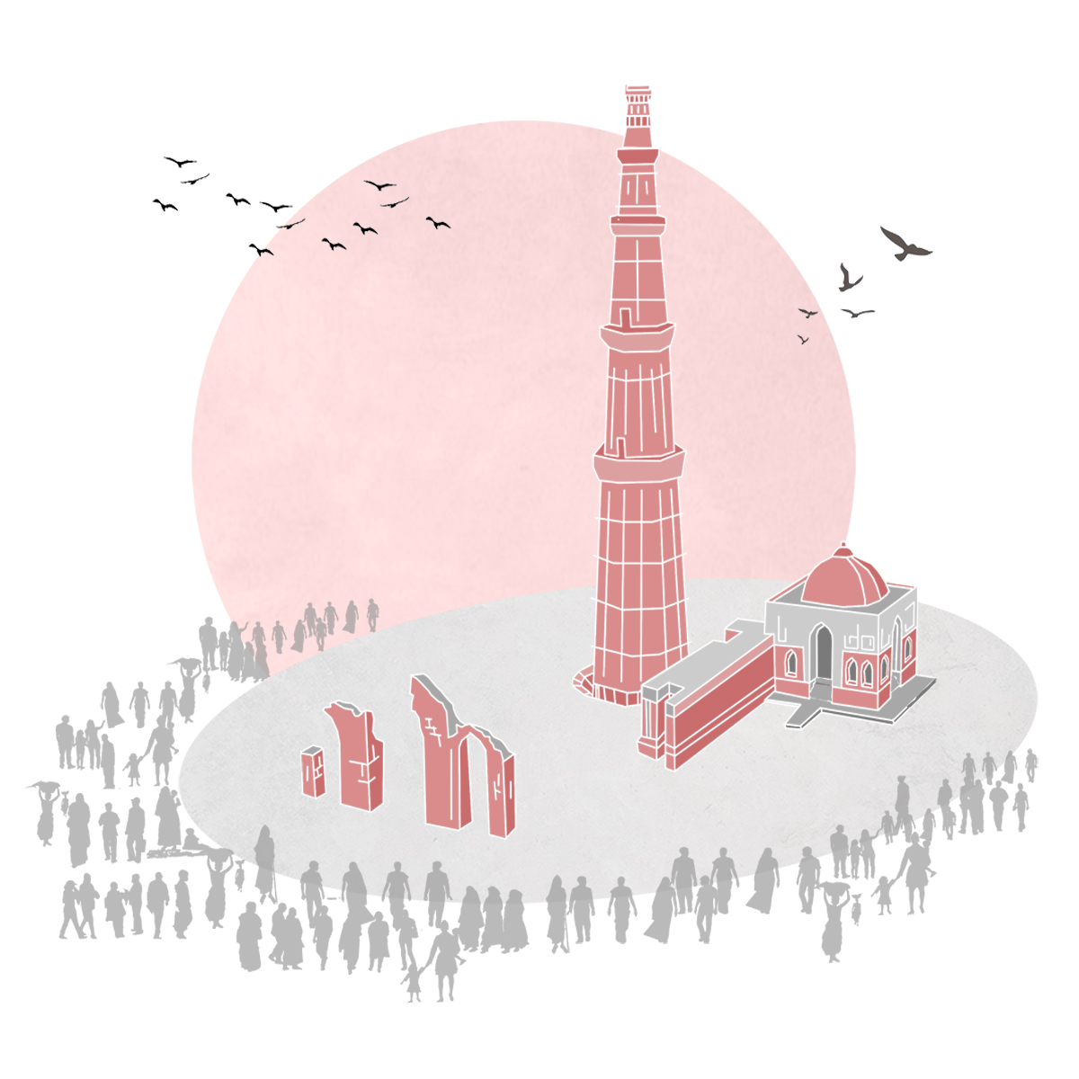
Karan Saharya (MDes ’20)
I intend to study the impacts of the architectural conservation of the Qutub Minar Complex on the urban village of Mehrauli, New Delhi, because the manner in which national- and international-level preservation and planning frameworks operate reveals underlying sociopolitical conflicts and instruments of spatial cleansing. The thesis seeks to develop a new framework for the examination of “heritage” in the post-postcolonial milieu that contextualizes the designated monument within the larger urban fabric and can inform policy using a stakeholder-centric approach. I hypothesize that the appropriation of “heritage” in contemporary urban India is a tool to develop elite tourist destinations while displacing local communities, expropriating land, and reiterating colonial-era identity politics.
A Guidebook to an Empty Land: Kalimantan and the Shadows of the Capital
A Guidebook to an Empty Land: Kalimantan and the Shadows of the Capital
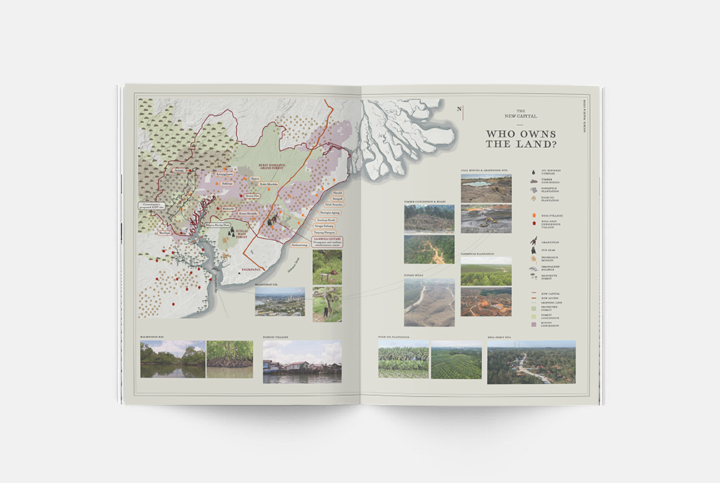
Angela Mayrina (MDes ’20)
Indonesia is an archipelago of 17,000 islands that were once made of separate kingdoms. The history of the islands and their political recognition is linked to their colonial past and practices of extraction. Years after its independence, the colonial legacy has continuously influenced the way the nation looks at its people, nature, and resources, as well as the interaction between its islands within the national planning, initiatives, and policies. Today, the legacy of past forces is especially prominent in the government’s decision to move the capital from Jakarta (in Java) to East Kalimantan (in Borneo). None of the proposals for the new capital talk about the impact of the move on the current social and environmental ecosystem in Kalimantan. The island is mostly discussed in terms of potential: an empty faraway land, a perfect location for the nation’s new capital—but of whose visions? Throughout history, the “emptying” of the land becomes a method of claiming space by ignoring its existing memory, history, and cultural practices.
A Guidebook to an Empty Land is an ongoing research project that seeks to archive the lives of different inhabitants of Kalimantan that are shadowed by the grand narrative. The archive attempts to reveal the complexities of human and nonhuman beings that are constantly intertwined in the conversation of this empty land. By de-emptying the land with stories, the archive provides an alternative where the history and inhabitants of Kalimantan should be considered and included in the conversation of the moving capital.
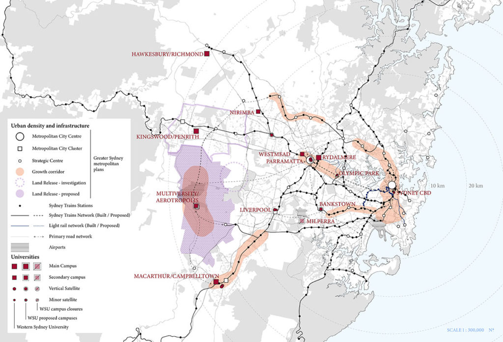
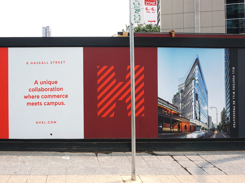
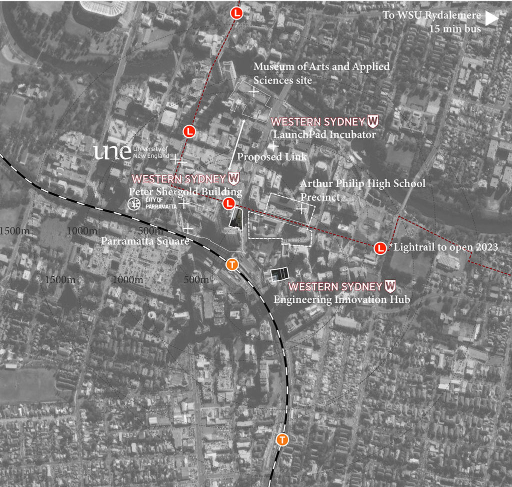
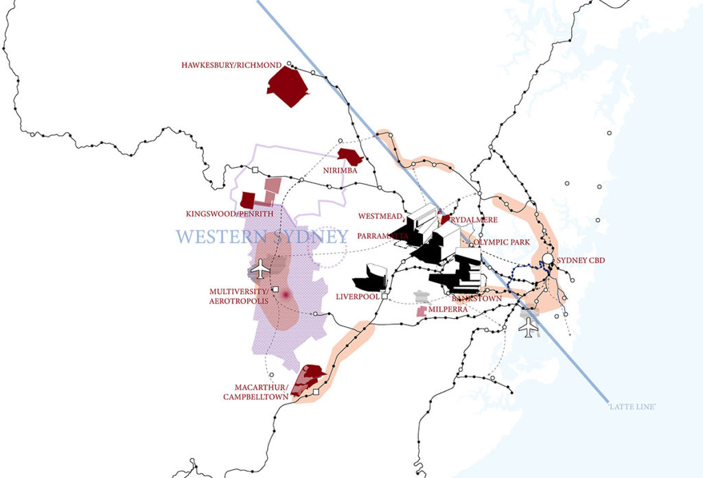
Rescaling the University: Vertical Campuses and Postindustrial Urban Restructuring in Western Sydney
Rescaling the University: Vertical Campuses and Postindustrial Urban Restructuring in Western Sydney

Justin Cawley (MAUD ’20)
Western Sydney University is a public university in Sydney, Australia. Since 2017, the university has expanded its network of campuses with new ‘vertical campuses’ in Parramatta, Bankstown and Liverpool.
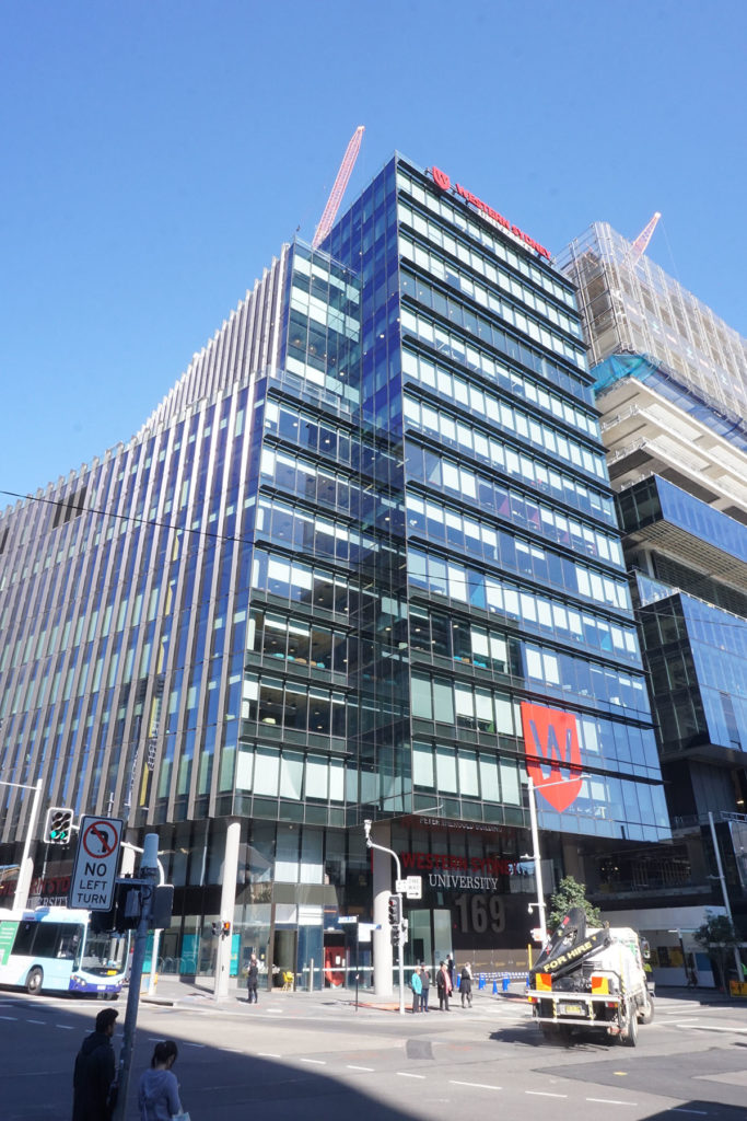
Vertical campuses are appearing across western Sydney as universities attempt to secure advantageous locations in rapidly developing suburban centres. Western Sydney University is the most visible proponent of this trend, adapting the commercial building type for academic purposes in commercial centres currently experiencing intense redevelopment under initiatives backed by the New South Wales’ state government’s plans for a ‘Global Sydney’.
The University has presented Vertical campuses as a way to re-embed its operations in both urban and economic space. In 2017, the University marketed the building as “a major economic catalyst that is set to transform Australia’s fastest growing city and the broader Western Sydney region” (Whibley 2017).
The central location of vertical campuses is strategic for creating new student catchments and for increasing accessibility of higher education institutions in the region. Commercial centres like Parramatta, Bankstown and Liverpool are attractive for their concentration of commercial firms, amenities and excellent connectivity on the metropolitan rail network.
The increased pressures placed on the University to manage its land assets and liabilities by successive waves of funding austerity accelerated the proliferation of the vertical campus model.
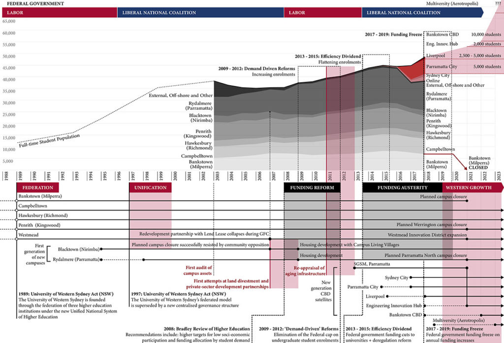
New vertical campuses are calibrated architecturally and contractually to reduce the friction to spatial expansion and contraction. One of the key features of Western Sydney University’s vertical campus model is that these spaces are leased, rather than owned. Flexibility has been a key driver in the development of new campus procurement strategies and design concerns.
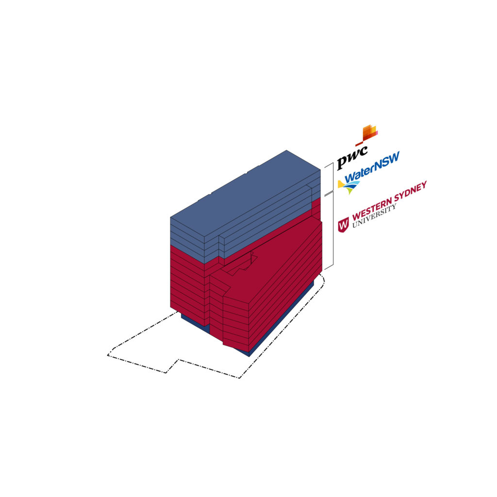
Despite the commercial appearance of vertical campuses, these new buildings are offering multiple publics new interior public spaces.
Drawing on Cedric Price’s Potteries Thinkbelt, this thesis argues that a Western Sydney Thinkbelt is vital for the coordination of new campus development that is more inclusive, locally-embedded and democratically-accountable.
The Next Southern Landmark: A Roadmap to Confederate Monument Redesigns and RFP for the Site of a Former White Supremacist Statue
The Next Southern Landmark: A Roadmap to Confederate Monument Redesigns and RFP for the Site of a Former White Supremacist Statue
Margaret Haltom (MUP ’20)
Following white supremacists’ acts of violence in Charleston, South Carolina (2015) and Charlottesville, Virginia (2017), activists and city officials mobilized to remove 52 Confederate monuments across the South. This contemporary era of monument removal is well-known—documented in news outlets and academic journals alike—and ongoing. Preservationists dispute the role of monuments in public memory, while progressive policymakers battle against heritage laws that prohibit their removal. But the future of these vacant pedestals, and, in particular, the role of community members and urban planners and designers to collectively create new landmarks in their place, remains relatively unexplored.
This thesis considers the context of, and process for, redesigning the sites of former Confederate monuments through a case study in Memphis, Tennessee. Focused on a former Nathan Bedford Forrest monument and its surrounding nine-acre park, I collaborate alongside a community coalition to create a process for redesign and Request for Proposals. I partner with the Lynching Sites Project (LSP) of Memphis, a coalition of teachers, faith leaders, local historians and other community members seeking to build monuments to victims of racial terror. Together, we ask: How might communities in the South reimagine and redesign former Confederate monuments? And, as the urban planner liaising with this community coalition, what is the planner’s role in creating inclusive processes to reclaim and transform these highly charged public spaces?
Through collaboration with LSP, as well as interviews with other activists, local leaders, planners, and designers, the thesis offers a roadmap for community-driven redesigns and explores the planner’s role in facilitating a more equitable design process.
That Sinking Feeling: Subsidence Parables of the San Joaquin Valley
That Sinking Feeling: Subsidence Parables of the San Joaquin Valley
Chelsea Kilburn (MLA I AP ’20)
This thesis explores the dissonance between the naturally blurry edge of groundwater and the structures of management that define the surface landscape of California’s San Joaquin Valley. In this region, extreme groundwater extraction causes land subsidence, thus physically and directly altering topography. The project frames a reality where imminent coastal migration leads to a soaring urban population in the Valley, further intensifying the need for extraction that not only provides drinking water but sustains some of the nation’s most productive agricultural ground. Sites of intervention consider local groundwater management typologies and imagine near-future scenarios in which design of the landscape can be used to rethink subsidence not as the effect of groundwater extraction but as a generative infrastructural force able to meaningfully shape the ground for the retention, remediation, and distribution of water that can then be utilized in the recharge of a critically overdrafted aquifer as well as in a speculative subversion of California’s constructed natural history.