Vallerani Micro Water Harvesting
Vallerani Micro Water Harvesting
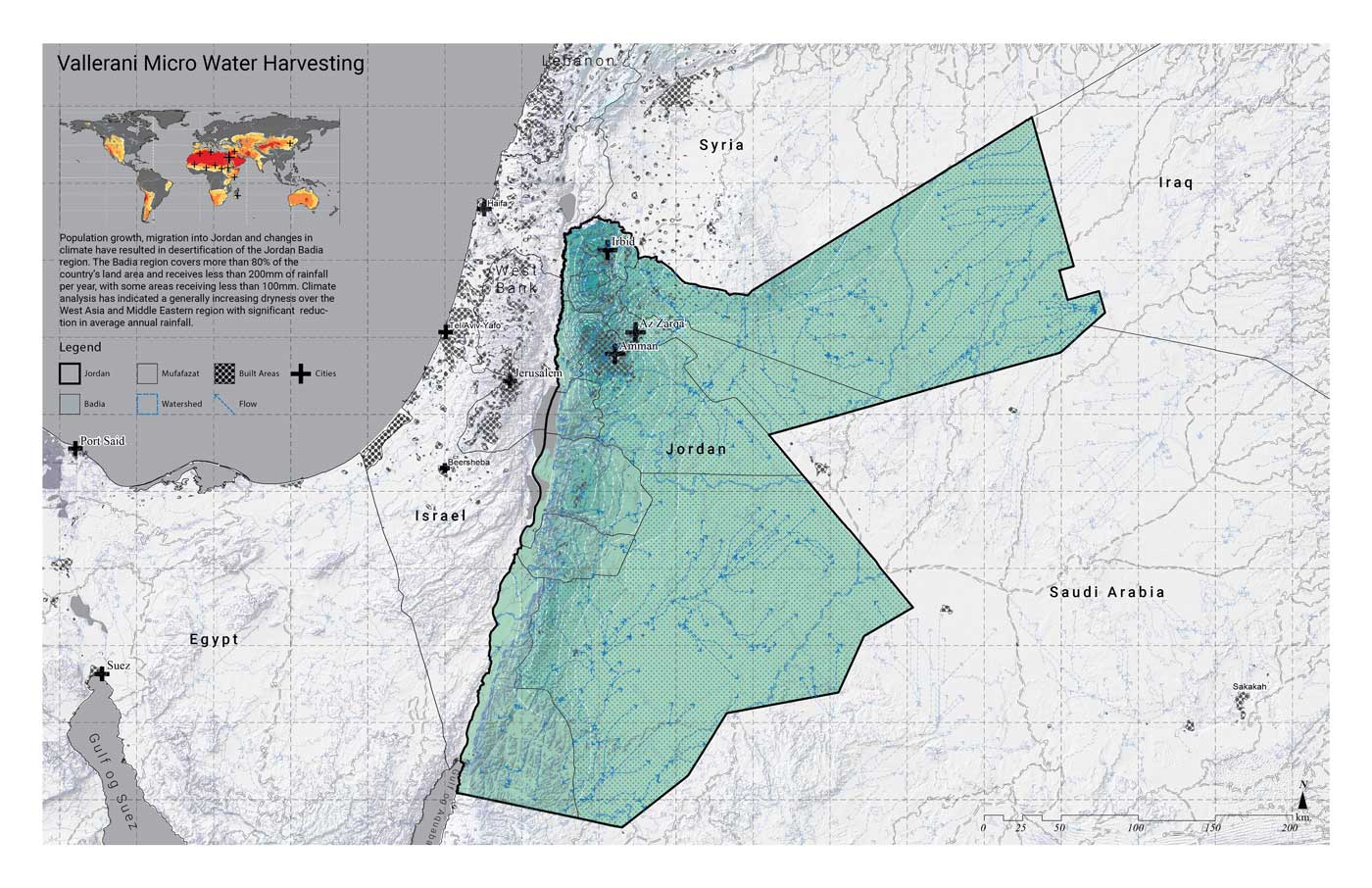
The Badia Region covers more than 80% of Jordan and receives less than 8 inches of rain per year, a number that has been decreasing due to climate change. Livestock herding, as well as deep ploughing and barley planting, have caused severe land degradation and the depletion of rangeland resources, including grasses. The diversity of plants throughout the Badia Region has declined, and introduced species have a low nutritional value. The soils across the region are crusted, resulting in a low water infiltration rate, sheet runoff, and erosion and gullying that can result in downstream flooding in Jordan’s capital, Amman. A microharvesting rainwater plan was developed using the Vallerani microharvesting technique to restore the desertified Badia. The technique uses the Vallerani plough, in which a tractor digs small water harvesting pits on the contours of hillside slopes, creating water retention and infiltration of surface runoff. These micro-catchments are planted with native shrub seedlings that are drought and salt-tolerant, which serve as fodder for livestock. The system catches an additional 12 inches of water yearly, which allows for the production of crops at a small scale, as well as livestock production that supports local needs at a relatively low cost of $32-116 per hectare. The micro-harvesting technique has been used across the world in Burkina Faso, Chad, China, Egypt, Kenya, Madagascar, Morocco, Niger, Senegal, Syria, Sudan, and Tunisia, as well as in Jordan. The implementation of Vallerani projects focuses on capacity building local stakeholders and farmers who can maintain the results of the mechanized system by caring for plants and developing local markets.
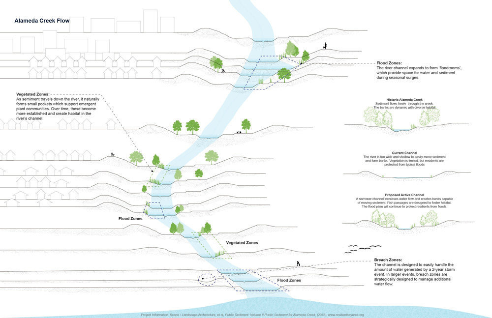
Public Sediment for Alameda Creek
Public Sediment for Alameda Creek
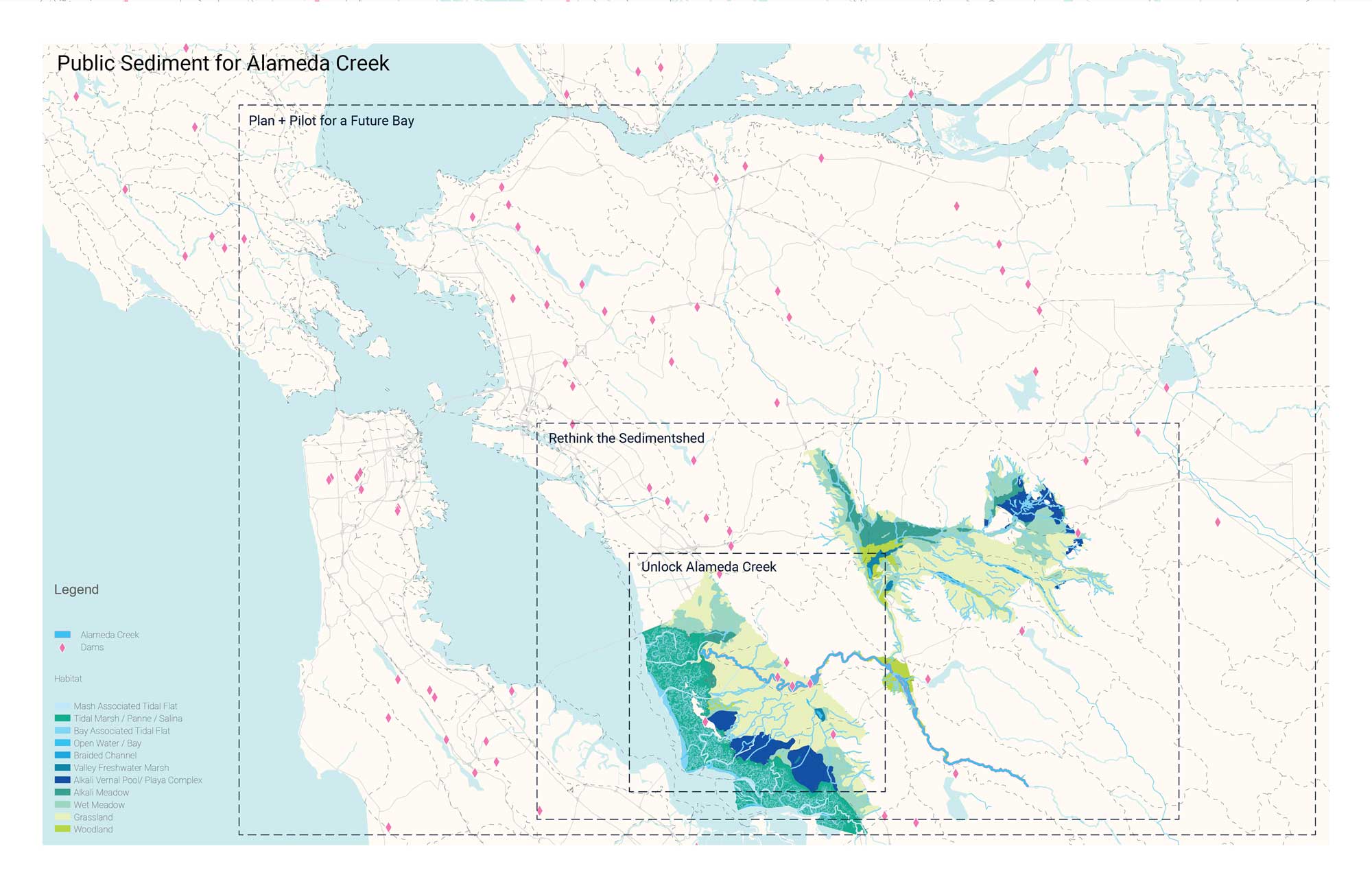
Resilient by Design was the Bay Area’s year-long collaborative design challenge for resilience to sea level rise, severe storms, flooding, and earthquakes. The challenge was led by design firms but included input from public officials, local, national, and international experts, as well as local residents. The initiative proposed nine different projects, including Public Sediment: Unlock Alameda Creek, which proposes that sea level rise adaptation must happen upstream and uses the creek to deploy sediment to downstream baylands to protect tidal ecosystems. The project is essentially a linear system including marshes and mudflats that moves more sediment than the existing creek down the watershed. Alameda Creek is the largest tributary to San Francisco Bay, and is arranged around a creek constituency from the headwaters to the downstream baylands, including living and constructed infrastructural elements, like upstream dams and downstream sills. The project balances differing requirements by the Army Corps of Engineers, including considerations on vegetation in an area that has been used as a channel for water and areas for overflow, as well as allowing tidal fluctuation into existing salt ponds. The project’s three key elements are sediment, people, and fish, as the proposal connects migratory fish to their historic spawning grounds and creates community spaces around the creek. These spaces, including mudrooms, seasonal crossings, and terrace trails, bring residents closer to the water. The project will ultimately require stewardship for longevity and an investment by the community after the initial construction.
References
Holmes, Rob, Tim Maly, and Brett Milligan. “The Pulse, the Sink and the Shortfall.” Ground Up Journal 04 (2015).
Links
Resilient Bay Area, Unlock Alameda Creek.
SCAPE Studio, Public Sediment for Alameda Creek .
Ashland Forest Resiliency Project
Ashland Forest Resiliency Project
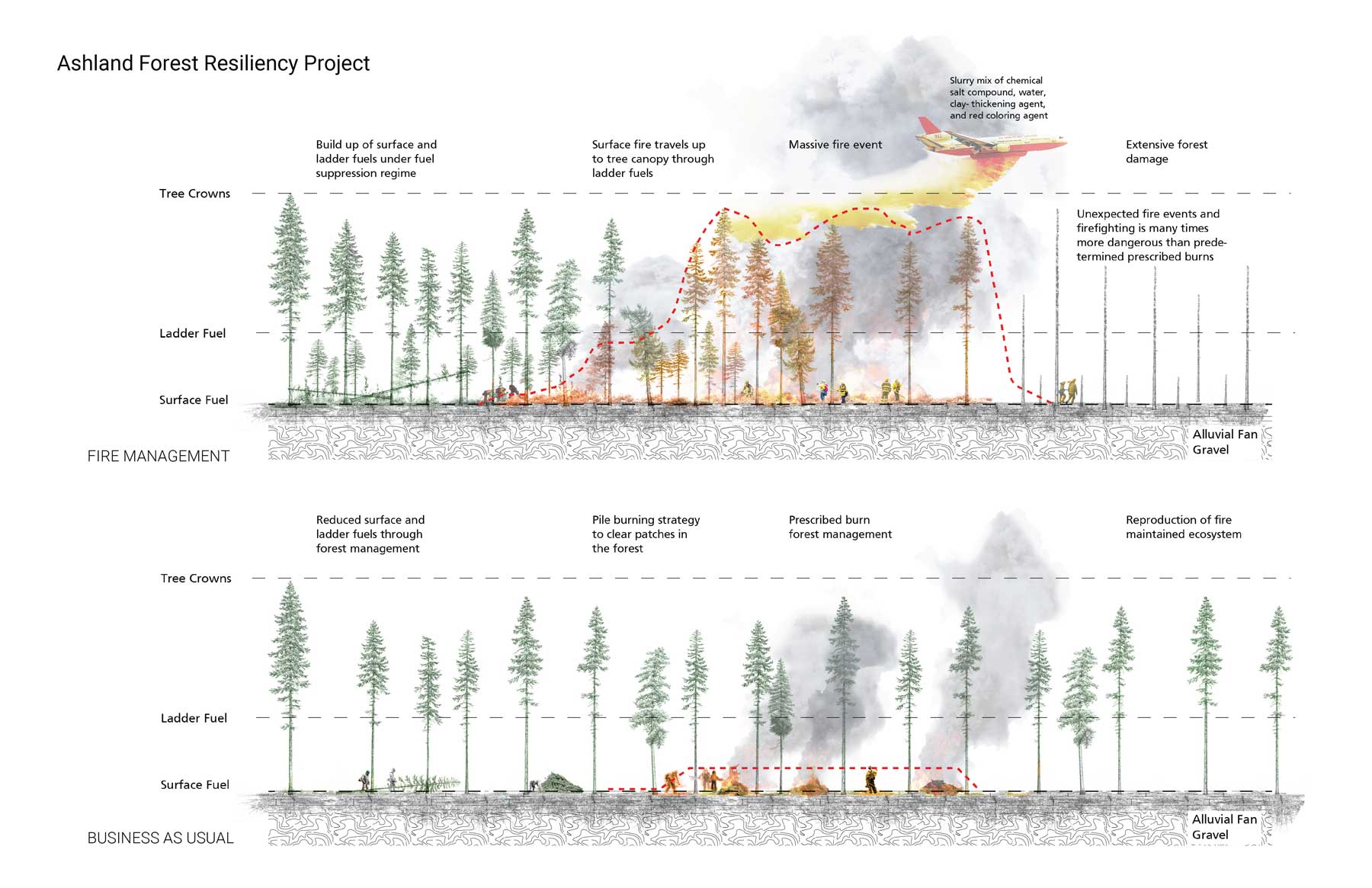
The Ashland Forest Resiliency Stewardship Project is an ongoing collaboration since 2010 between the Lomakatsi Restoration Project, the City of Ashland, The Nature Conservancy, and the United States Forest Service. The project covers 7,600 acres of land to support, preserve, and restore wildlife habitat, water quality, and a healthy forest ecosystem. While the primary objective of the project is to reduce the risk of large-scale wildfire and help large, old trees survive fire, insects, and disease, there are also initiatives to ensure that watershed values, from human life and property, older forests, abundant, clean drinking water, wildlife habitat, and ecological sustainability. Fire was suppressed for over a century across the Ashland watershed, during which time young Douglas fir and white firs have grown and shaded groundcover, killing older trees and fueling wildfires that climb like ladders to the tree canopy. The Lomakatsi Restoration Project is a group of ecologists who have worked to facilitate partnerships and build community across landscape-scale restoration projects, all of which are community-based and include intensive meetings. The Ashland Forest Resiliency Project has used ecological thinning across the watershed and a management strategy that limits camping and campfires year-round to protect our watershed and community. The project uses processes of yarding, both in helicopters and ground-based management, and highlights the challenges of bringing heavy machinery into the forest on existing roadways and ensuring that slopes do not erode during rainfall. Controlled burns are being introduced with required safety precautions to consume leaf litter, leaves, and branches.
References
Shannon, Kelly and Danielle Kaufman. “California is Burning: Rethinking the Wildland/(Sub)urban Interface.” Landezine. January 9, 2018. http://landezine.com/index.php/2018/01/california-is-burning-rethinking-the-wildland-suburban-interface/
Schuler, Timothy A. “Taking the Wind out of Wildfire.” Landscape Architecture Magazine (March 2019): 96-105.
Gillison, Lindsey, Cathy Whitlock and Glynis Humphrey. “Resilience and fire management in the Anthropocene.” Ecology and Society 24, no. 3 (2019):14.
Davis, Emily and Eric M. White. “Collaboration and stewardship authority: the Ashland Forest Resiliency Project.” 2015. https://scholarsbank.uoregon.edu/xmlui/handle/1794/19626
Links
Ashland Forest Resiliency Stewardship Project
Cheri Hammons, “The Ashland Forest Resiliency Stewardship Project : Ashland’s Chamber maps out its greatest resource,” Southern Oregon Magazine, July 15, 2014.
TransMilenio and Bikeways
TransMilenio and Bikeways
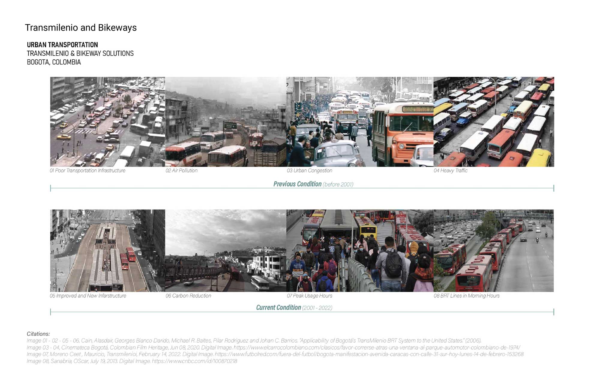
Enrique Peñalosa was a two-term mayor of Bogotá. He served from 1998 to 2001 and again from 2016 to 2019. During his first term as mayor, he developed a bus rapid transit (BRT) system called the TransMilenio. The TransMilenio system replaced a Transportation Master Plan, including a metro system and elevated highways. The mayor rejected the metro plan as it would only serve residents in the city’s center, offering mobility to wealthy residents while neglecting the city’s periphery. The additional funds that were saved by operating the TransMilenio were used to build 155 miles of bike lanes, called CicloRuta, in the city that now move 5% of the city’s population. In addition to the bikeways and additional sidewalks, a series of parks and plazas were constructed across the city. The CicloRuta project was controversial for seizing land in front of private residents and building on the sidewalk, thus taking space away from landowners without changing the legal ownership of the bikeway. The TransMilenio is essentially a bus feeder system, with 104 stations and 1,000 buses, moving 43,000 passengers per hour in each direction. Some highways are designated bus-only, allowing for rapid public transportation on bus lines, which are cheaper to install than metro or rail systems. After 20 years, the TransMilenio system requires updates to infrastructure, especially the buses themselves, but the success of the system has shifted the city away from private vehicle ownership toward bike and transit ridership.
References
Peñalosa, Enrique. “Bogotá’s Experience in Sustainable City Development. Asian Development Park Knowledge Showcases: Regional Transport 2” (2008). https://www.adb.org/sites/default/files/publication/27832/bogotas-experience.pdf.
Links
Jonna McKone, “TransMilenio: Ten Years Down the Line ,” TheCityFix, December 22, 2010.
Tanya Snyder, “Enrique Peñalosa: Democracy Is Bus-Only Lanes and Protected Bikeways ,” StreetsBlogUSA, December 9, 2013.
Chagga Homegardens
Chagga Homegardens
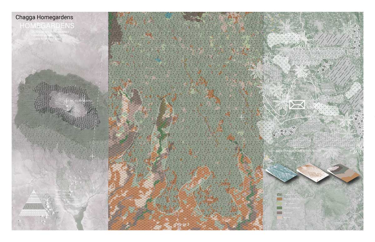
Homegardens are subsistence gardens that provide a supplemental source of food and nutritional security in urban and rural areas across Africa, the Middle East and Asia. These gardens are small plots adjacent to human settlements that are an integral part of family farming and local food production, often with hundreds of species of food, herb and medicinal crops in a small area. Homegardens cultivate mixed crops that may be unavailable or prohibitively expensive at local markets. The Chagga homegardens are a multistorey agroforestry cropping system cultivated by the Chagga people on kihamba, or ancestral land. The communities have selected the species that are most useful for food, fodder and fruits on the slopes of Mt. Kilimanjaro and grown them on the rich volcanic soils, transforming the existing forest. The Chagga homegardens use multi storey agroforestry to provide shade for coffee, build living fences that fix nitrogen, produce fodder and mulch, provide forage for bee species, and reduce pests. Additionally, animals, including cattle and goats are kept within the gardens, which have a varied spatial organization based around zones that produce food crops, coffee and cash crops, and medicinal plants, as well as a zone for banana plants and trees used for timber production. Over 100 crops exist within the homegardens, creating a rich, biodiversity model of agroforestry land use with a management model that is passed down across generations.
References
Fernandes, E.C.M., A. Oktingati and J. Maghembe. “The Chagga home gardens: A multi-storeyed agroforestry cropping system on Mt. Kilimanjaro, Northern Tanzania.” Food and Nutrition Bulletin 7, no. 3 (1985): 1-8. 10.1007/BF00131267.
Nair, P.K.R. “Climate change mitigation: A low-hanging fruit of agroforestry.” In Agroforestry: The Future of Global Land Use, edited by P.K.R. Nair and Garrity Ramachandran, 31-67. Amsterdam: Springer, 2012.
Links
Pleistocene Park
Pleistocene Park
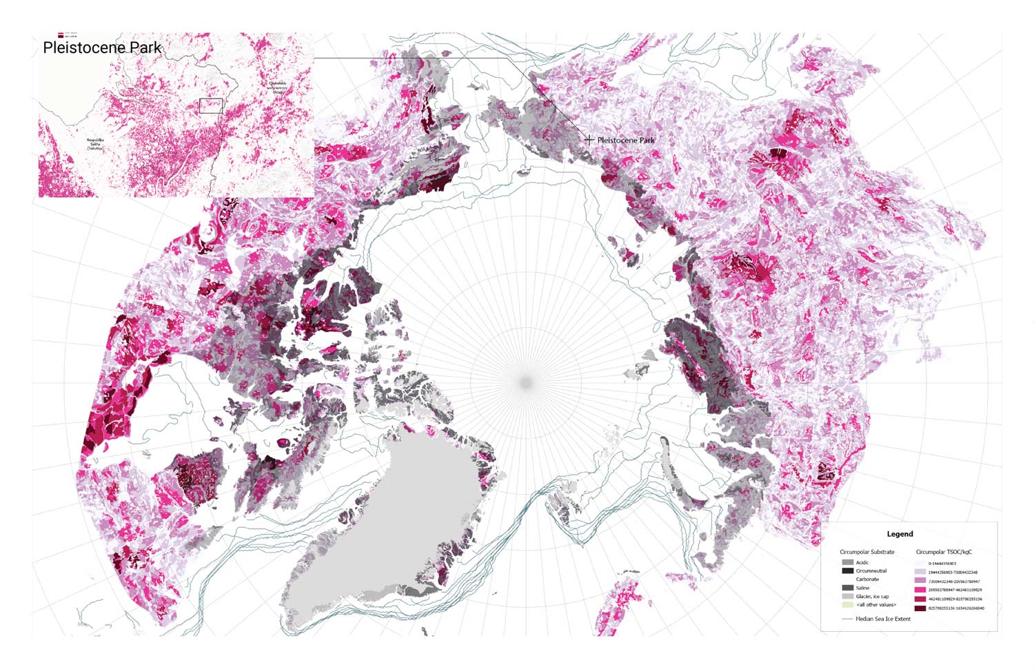
At the end of the Pleistocene, the steppe ecosystem was dominant across the planet, with a high density of animals, a thick herbaceous grass layer, and high rates of biogeochemical cycling, including carbon sequestration in grasslands. After the Pleistocene, the northern steppes were sinks of carbon under glaciers, with significant carbon stores across the steppe-tundra ecosystem. The warming of the permafrost, a permanently frozen layer of ground that circles the planet’s northern latitudes, would release the same amount of greenhouse gases as all other anthropogenic emissions combined. Pleistocene Park is dedicated to restoring the grazing ecosystems of the Arctic, led by Sergey and Nikita Zimov, father-son scientists who began Pleistocene Park through their work at the Northeast Science Station in the Sakha Republic in eastern Siberia. The grasslands absorb less heat than the forests and scrub that has grown, so the boreal forest is deforested to increase the albedo effect. Sergey Zimov works closely with Harvard geneticist George Church, who is attempting to deliver a cloned wooly mammoth to Pleistocene Park by 2028. Today, the park is roamed by several existing large herbivores, from bison, musk oxen, and wild horses that roam the 50 square mile nature reserve. The park was founded in 1996 and is proposed as a prototypical property that could be extended across the steppe ecosystem from North America to Arctic Siberia. The large herbivores would continue to maintain the grassland, ensuring it does not transition back to the forest. At the same time, they trample snow in the winter, deepening the permafrost and locking carbon dioxide in the soil.
References
Andersen, Ross. “Welcome to Pleistocene Park .” The Atlantic, April 2017.
Links
Copenhagen Cloudburst Plan
Copenhagen Cloudburst Plan
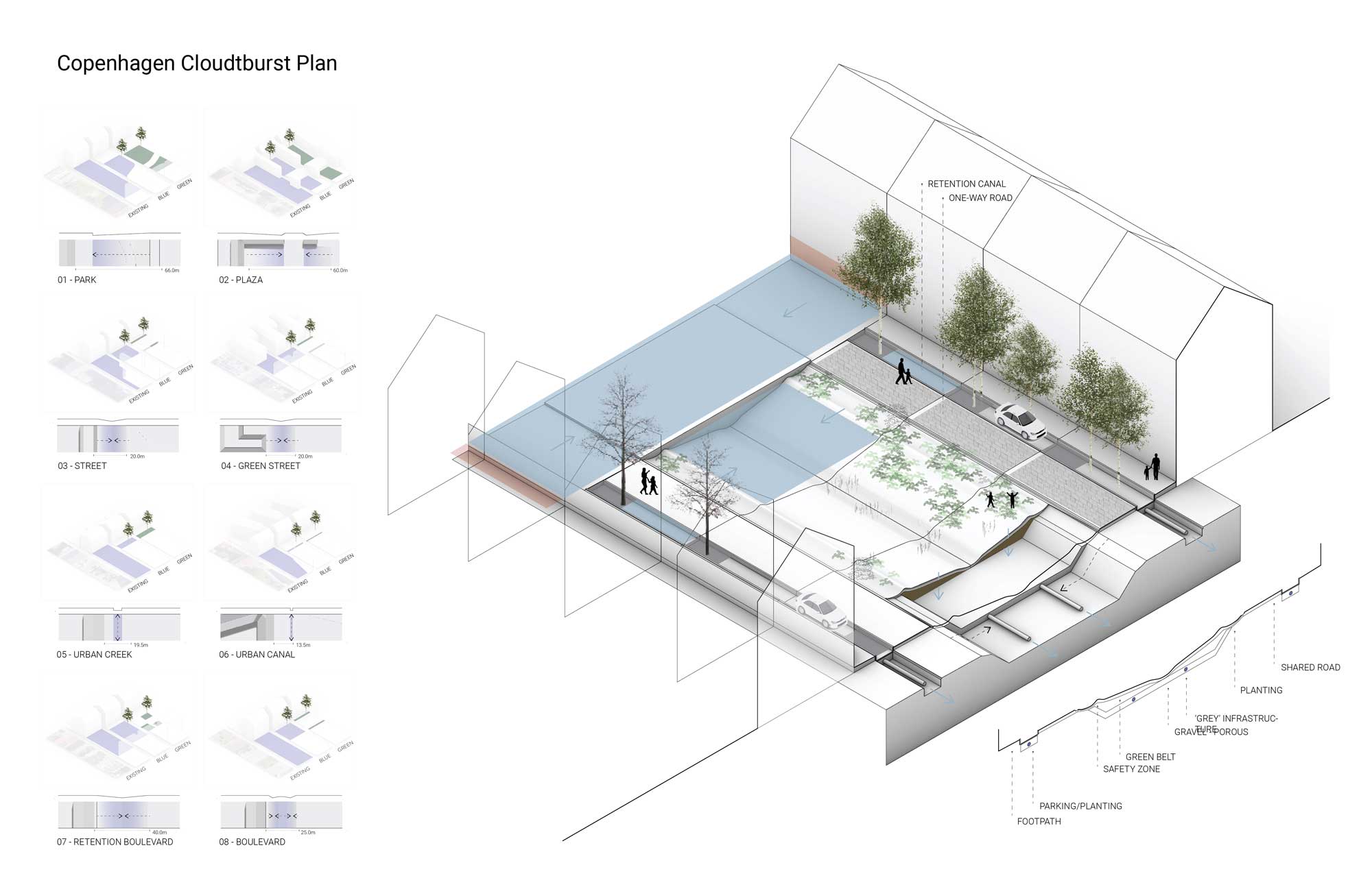
In 2011, Copenhagen was struck by a 1,000-year storm event, a Cloudburst, that flooded the city with three feet of water, causing over $1 billion in damage. The city engaged in a planning period to create the Cloudburst plan with the idea of Blue-Green solutions. These solutions are low-tech, on the surface, not engineered underground, and interactive. These climate adaptive solutions take place within the confines of urban space. The process followed a six-step procedure to integrate a Blue-Green approach, beginning with data gathering and investigation, modeling and mapping, a cost-of-doing-nothing scenario, a design period, community involvement, and design interaction. It concluded with a detailed socioeconomic cost-benefit analysis that tested two masterplan solutions. The masterplan variations, the conventional scenario, and the Blue-Green scenario were developed together to quantify the benefits of the adaptive scenario. The project was financed through a public-private partnership called the Copenhagen Formula, in which existing cities are retrofitted through Blue-Green solutions. Private developers invested in the government’s plan, and it gained traction for its focus not only on the areas where flooding occurs but also on upstream and upland areas where residents do not see the consequences of heavy rainfall. The plan designates a clear order of priority, in which high-risk areas, as identified in a climate adaptation plan, are addressed first, followed by areas where measures are easy to element, areas with ongoing urban development projects, and lastly, in areas where other policy directives are being followed.
References
Ziersen, J. J. Clauson-Kaas and J. Rasmussen. “The role of Greater Copenhagen Utility in implementing the city’s Cloudburst Management Plan.” Water Practice and Technology 12, no. 2 (2017): 338-343.
Delhi Stepwell Restoration
Delhi Stepwell Restoration
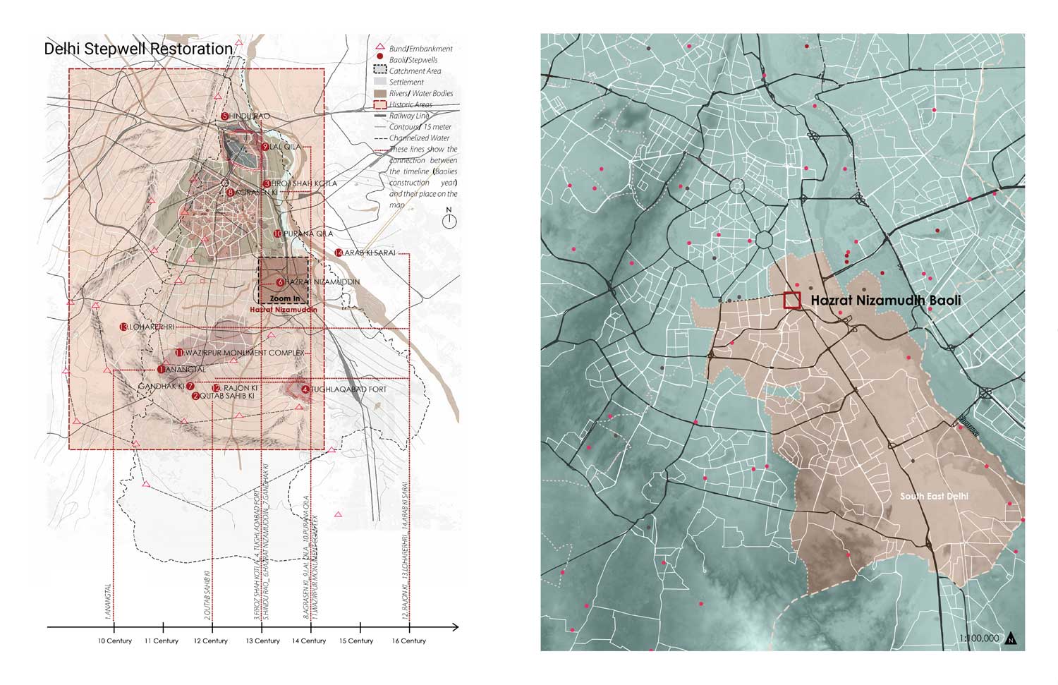
Baolis, or stepwells, are underground reservoirs where water can be stored close to the groundwater level to ensure a constant water supply during the dry season, one of two monsoon seasons across the Indian subcontinent. Baolis were first constructed as rock-cut stepwells between 200 and 400 AD to ensure water during periods of drought. While stepwells are utilitarian, they also have significant religious, social and cultural significance, and some have rooms built to provide shelters to caravans. The earthquake-proof construction and cool microclimate under the earth has made baolis a sanctuary for collecting water as well as bathing, meditation and prayers. Delhi has an estimated 32 stepwells, 16 lost or demolished, and 14 accessible to the public. Three of the baoli are permanently dry. The Indian National Trust for Art and Cultural Heritage began a project to de-silt and restore the 16 baoli that have not been lost, in an effort to bring back traditional means of water security and resilience against an increasingly erratic monsoon cycle that has deepened the water crisis across India, especially in urban centers like Delhi. To rehabilitate the stepwells, garbage and debris must first be removed, and then the stepwell must be desilted to reconnect the reservoir to the water table. In areas where there is significant unregulated pumping from wells, groundwater levels may be significantly below the lowest depths of the baoli, presenting a need for stewardship not only of the stepwell itself, but also equitable water policy for the surrounding areas to recharge groundwater.
References
Chandra, Sharad. “Steps to Water: Stepwells in India.” Chitrolekha International Magazine on Art and Design 5, no. 2 (2015).
Unnikrishnan, Hita, Sreerupa Sen and Harini Nagendra. “Traditional water bodies and urban resilience: a historical perspective frm Bengaluru, India.” Water History 9 (2017): 453-477.
Links
Indian National Trust For Art and Cultural Heritage (INTACH), Delhi Chapter, “Baolis of Delhi,” Google Arts & Culture
“India’s magnificent stepwells are relics of a nuanced history,”The Economist, July 13, 2019.
Panchali Dey, “Baolis of Delhi: Tracing the steps of incredible stepwells,” Times of India, December 3, 2018.
Victoria Lautman, “India’s Forgotten Stepwells,” ArchDaily, June 28, 2013.
Richi Verma, “Delhi: Dwarka’s Lodi-era baoli restored,” Times of India, May 10, 2015.
Swansea Bay Lagoon
Swansea Bay Lagoon
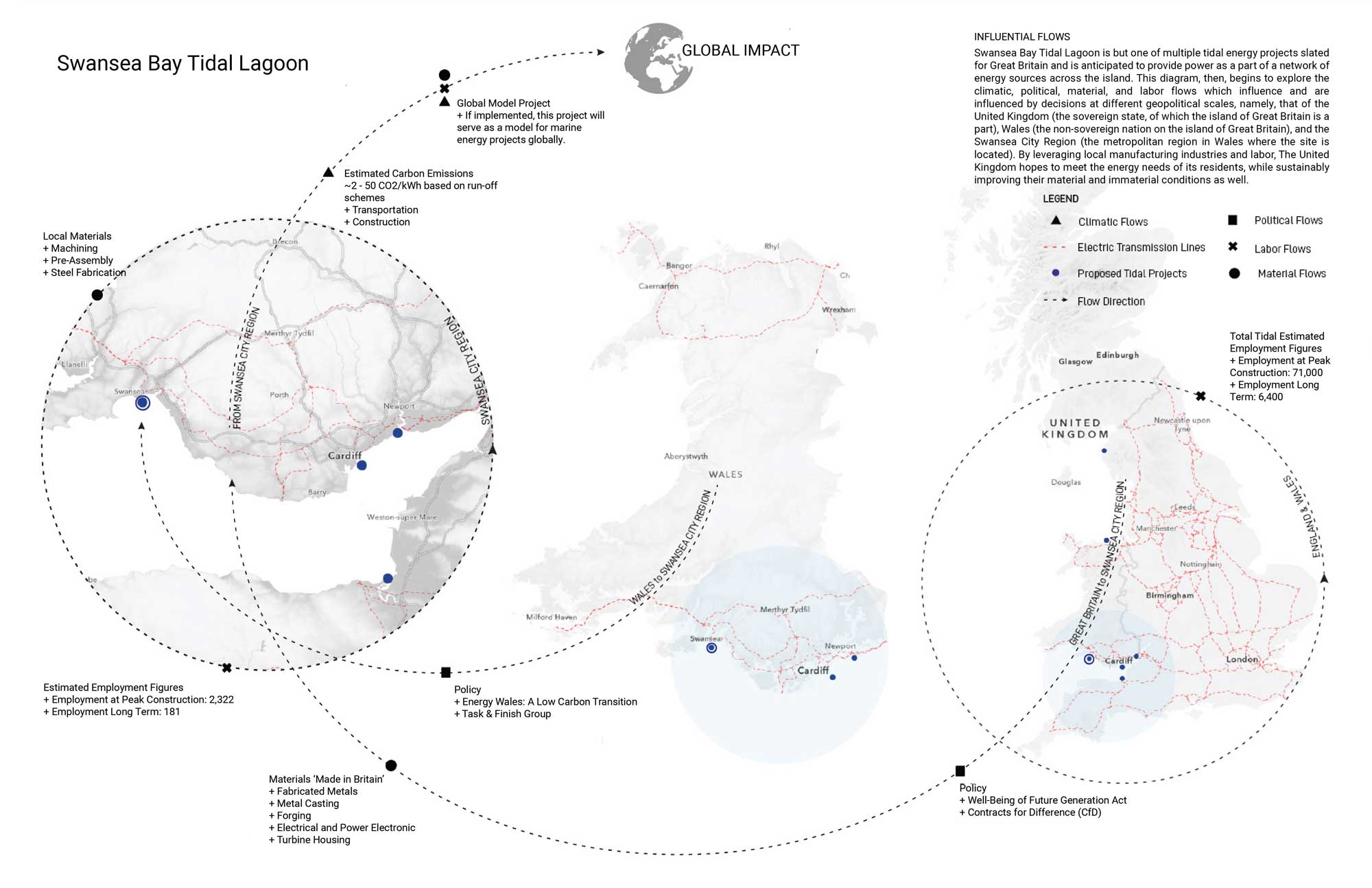
Swansea Bay was once home to a thriving oyster industry that employed 600 residents in the late 1800s. Since that time, overfishing, disease, and population have wiped out the oyster trade, and the bay has been severely polluted by sewage outfalls that were closed in 1996. The Swansea Bay Tidal Lagoon is a U-shaped breakwater proposed on the southwest coast of Wales. The project would be the world’s first tidal lagoon power plant, with hydroturbines located within the breakwater that generate electricity as the tide rises and falls in the lagoon twice a day, thus generating electricity four times each day with the cycles of the tides. The project could generate electricity for 155,000 homes over 120 years if completed. Construction was expected to begin in 2020, but the United Kingdom government rejected the project due to expense. The design of the lagoon includes a walkway over the breakwater, as well as lookout points with public gathering spaces and sheltered rooms for fishing. The project uses textile geotubes to create a breakwater, filled with sand and covered with a rock barrier, with heavy rocks covering the seaward side nine feet above the high tide level. In addition to pedestrian and bike access, an electric train is proposed. A marine ecological restoration project is proposed within the lagoon, called an aquatic farm, which will include mussels, oysters, and eelgrass are proposed, in addition to a 5-mile marine reef beyond the lagoon.
Links
Adam Vaughn, “Swansea tidal lagoon plan revived – without government funding ,” The Guardian, February 4, 2019.
“Swansea Bay tidal lagoon: Last-ditch bid to resurrect project ,” BBC, December 4, 2019.
Confronting Climate Change: A Foundation in Science, Technology and Policy (HKS)
This course will consider the challenge of climate change and what to do about it. Students will be introduced to the basic science of climate change, including the radiation budget of the Earth, the carbon cycle, and the physics and chemistry of the oceans and atmosphere. We will look at reconstructions of climate change through Earth history to provide a context for thinking about present and future changes. We will take a critical look at climate models used to predict climate change in the future, and discuss their strengths and weaknesses, evaluating which forecasts of climate change impacts are robust, and which are more speculative. We will spend particular time discussing sea level rise and extreme weather (including hurricanes, heat waves, and floods). We will look at the complex interactions between climate and human society, including climate impacts on agriculture and the relationship between climate change, migration and conflict. We will also discuss strategies for adapting to climate change impacts, and the implications of those strategies for sub-national and international equity.
The last half of the class will consider what to do about climate change. First, we will review the recent history of greenhouse gas emissions, as well as various national and international efforts to limit them in the future. We will discuss reducing carbon emissions using forestry, agriculture and land use, and then focus on how to transform the world’s energy system to eliminate CO2 emissions. We will conclude by examining different strategies for accelerating changes in our energy systems to limit greenhouse gas emissions.
The course is intended as a foundational course on climate change for students from around the university, preparing them for more specialized courses in their individual concentrations or degree programs. No prerequisites are required; students will be encouraged to apply their different preparations and interests to the various individual and group assignments. The course emphasizes the scientific and technological aspects of climate change (including the clean energy transition), but in the context of current issues in public policy, business, design and public health.
This course is jointly listed with HKS as IGA 402.
Please note, the first day of lectures will be Wednesday, September 6 (at FAS). The first day of discussion sessions will be on Monday, September 11 (at HKS). Please see HKS IGA 402 syllabus for details.
Because of the discussion component of the course, all graduate students are required to attend the Monday afternoon discussion sessions in person. Graduate students are encouraged to attend all of the GenEd 1094 lectures in person, but are allowed to attend up to two thirds of the classes through video feed (Panopto) to accommodate students from Longwood and Allston campuses. If students cannot watch the lectures live, they can also watch them later if they view them within 24 hours. If you cannot attend lectures on a regular basis for some other reason, please contact the instructor by email and he will try to make alternative arrangements that will allow you to participate.