Resolution Grounds: Designing with the Fragmented Survey
Resolution Grounds: Designing with the Fragmented Survey
Paris Bezanis (MArch I ’25)
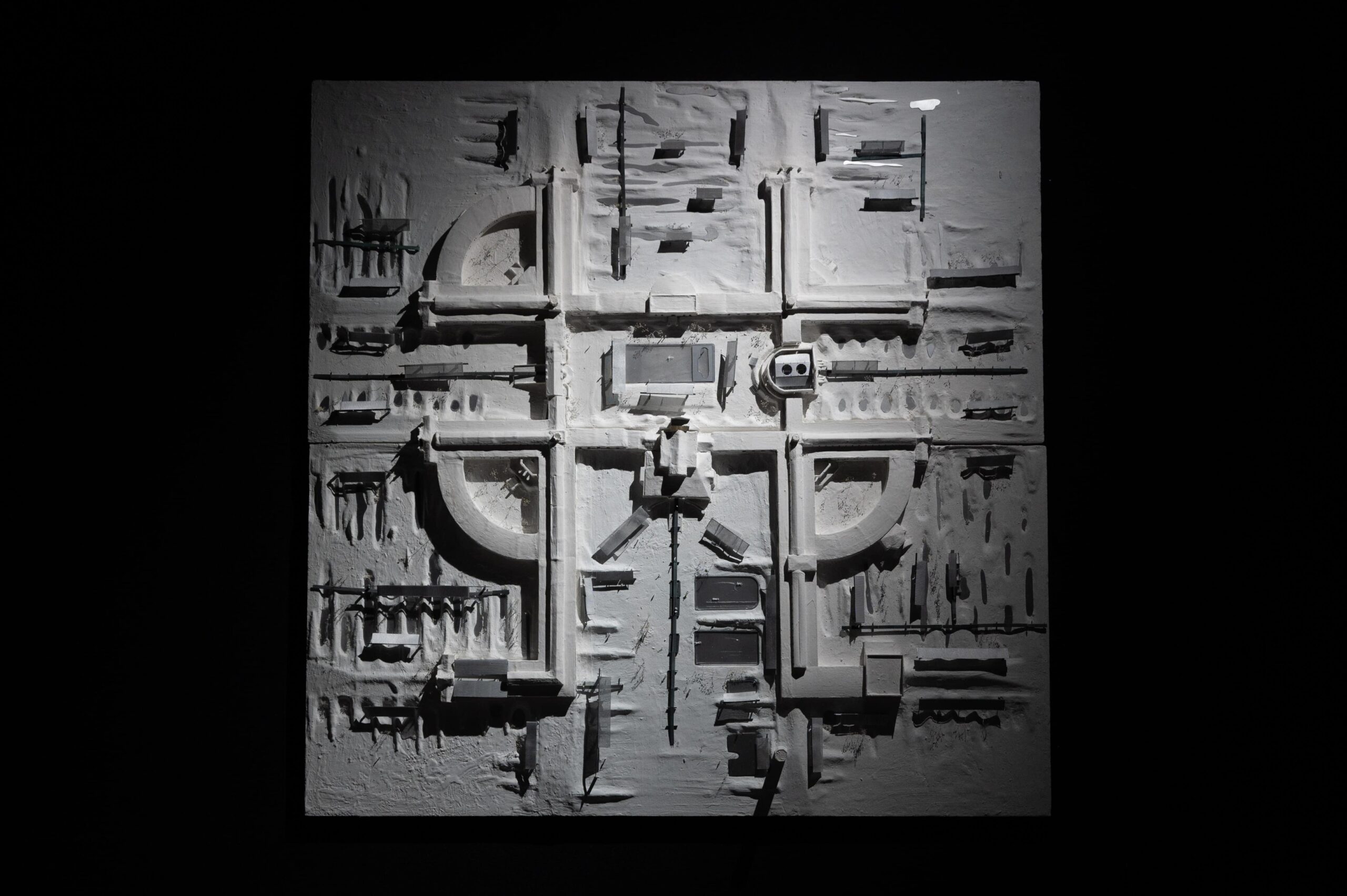
Resolution Grounds: Designing with the Fragmented Survey repositions the architectural survey as a site of epistemic and political contestation, challenging the premise that more data yields better design. At the Kuyalnik Estuary in southern Ukraine—a landscape shaped by ecological collapse, centuries of colonial therapeutic infrastructures, and wartime inaccessibility—the disciplinary pursuit of total visual capture is not only infeasible but ethically compromised. In its place, the thesis advances the fragmented survey: a methodology that constructs spatial records from open source but incomplete, low-resolution, and often extralegal visual material. Scraped drone footage, social media images, and archival fragments are not treated as raw inputs, but as situated digital artifacts, reconstructed through AI-assisted workflows that infer missing metadata and spatial relationships. Screenshots from embedded Google Maps flyovers are processed using monocular depth estimation tools like Marigold and Stable Diffusion, then passed through photogrammetry platforms such as RealityCapture or MeshRoom. Photogrammetry is operative here because it enables the translation of heterogeneous, often degraded visual material into spatial data—producing point clouds and meshes that can be acted on architecturally. The resulting outputs range from broken, sparse point clouds to partial meshes with high degrees of inference—surfaces warped by algorithmic guesswork and visual noise. These are supplemented with inpainting, deblurring, and neural alignment techniques, and further anchored by high-resolution Polycam scans captured on-site by local collaborators. The result is not a seamless model of a digital twin, but a digital sibling: an unstable, multiscalar, and composite reconstruction that foregrounds the technical and political conditions of its own assembly.
This composite and fragmented survey becomes a design instrument calibrated to its own inconsistencies. Each resolution informs a different scale of architectural intervention: coarse, inferred terrains underpin landscape-scale berms and sedimentary commons; intermediate scans guide the reuse of precast concrete elements from nearby Soviet housing stock; high-resolution fragments support detailed tectonic insertions within sanatorium ruins. By designing through interference rather than resolving it, the project reframes digital surveying not as a pursuit of mastery, but as a situated, ethical design practice. Here, resolution is not merely a technical attribute but a methodological stance—foregrounding approximation, scarcity, and collaboration as design prompts. In doing so, the project proposes a new role for computation in architecture: not as a tool for seamless visualization or predictive modeling, but as a critical mapping practice attuned to the politics of fragmented data, uneven visibility, and constrained access—where what can be
rendered is shaped by platform infrastructures, geopolitical opacity, and the contingencies of image circulation.
CREDITS
DDP Credits and Attributions
Paris Bezanis
Spring 2025
Credits and attributions are listed below for any work shown in the thesis project that is not exclusively my own.
Citations
- Bingxin Ke, Kevin Qu, Tianfu Wang, Nando Metzger, Shengyu Huang, Bo Li, Anton Obukhov, and Konrad Schindler. “Marigold: Affordable Adaptation of Diffusion-Based Image Generators for Image Analysis.” arXiv, May 14, 2025. https://arxiv.org/abs/2505.09358 . Code repository. PRS_ETH. https://github.com/prs-eth/marigold .
- Riku Murai, Eric Dexheimer, and Andrew J. Davison. “MASt3R-SLAM: Real-Time Dense SLAM with 3D Reconstruction Priors.” arXiv, submitted December 16, 2024; revised June 2, 2025. https://arxiv.org/abs/2412.12392 . Code repository. Imperial College London. https://github.com/rmurai0610/MASt3R-SLAM .
- Carousel image 21, bottom. Pierre-Yves Brunaud, photograph of paysarchitectures project in Geneva, 2017. Used as the base for a digital collage by the author.
Labor
Plastering model: Olivia Champ, Maria Ferrari, Hannah Kim
Planting and boardwalk assembly: Griffin Snyder, Emily Hayes, Aneesh Devi, Becca Schalip
Interiors Visualization Assistance: Denis Sola
Mumbai INformal
Mumbai INformal
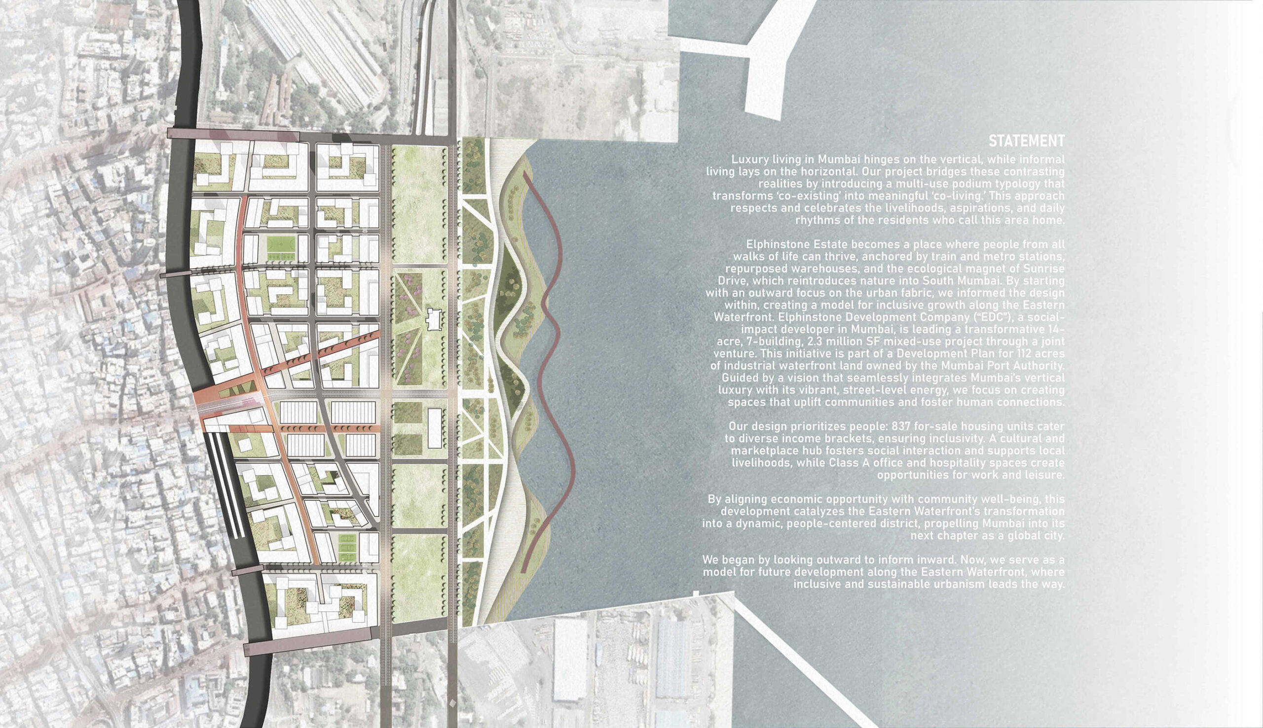
Kiara Nahomy Wong Siu (MAUD ’25), Teresa Ka Weng Lai (MAUD ’25), Henry Black (MUP ’26), and R. Kofi Boakye Bempong (MUP/MPA ’26)
Luxury living in Mumbai hinges on the vertical, while informal living lays on the horizontal. Mumbai INformal bridges these contrasting realities by introducing a multi-use podium typology that transforms “co-existing” into meaningful “co-living.” This approach respects and celebrates the livelihoods, aspirations, and daily rhythms of the residents who call this area home.
ARCA
ARCA

Andres Lira Vigneaux (MArch II ’25), Brittany Arceneaux (MRE ’26), Noemi Iten (MDes ’25), and Dennis Sola (MArch II ’25)
ARCA is a housing construction system designed to make gentle density both feasible and compelling by rethinking how housing is built – combining architectural precision, material innovation, and contextual design. ARCA’s pilot project is situated on a standard R1 lot in Los Angeles’s Playa del Rey neighborhood – a vacant parcel that embodies both the challenges and opportunities of low-density zoning.
Infilling with Outbuildings
Infilling with Outbuildings
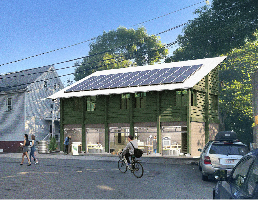
Nicky Rhodes (MArch I ’26), Ian Erickson (MArch I ’25), Nathan Lowrey (MRE ’26), Vincent Jackow (MArch/MIT)
Infilling with Outbuildings centers on transforming garages in Somerville, MA into affordable live-work spaces for local artists and artisans by utilizing sustainable building materials, architecturally innovative designs, and efficient construction practices. Recognizing the dispersed yet standardized nature of these structures and the urgency of the affordability problem, the proposal prioritizes easily replicable design prototypes that can be quickly implemented, adding density and dynamic, mixed-use energy to neighborhoods.
Walnut Park Place: Affordable Ownership Opportunities for the Egleston Square Community
Walnut Park Place: Affordable Ownership Opportunities for the Egleston Square Community
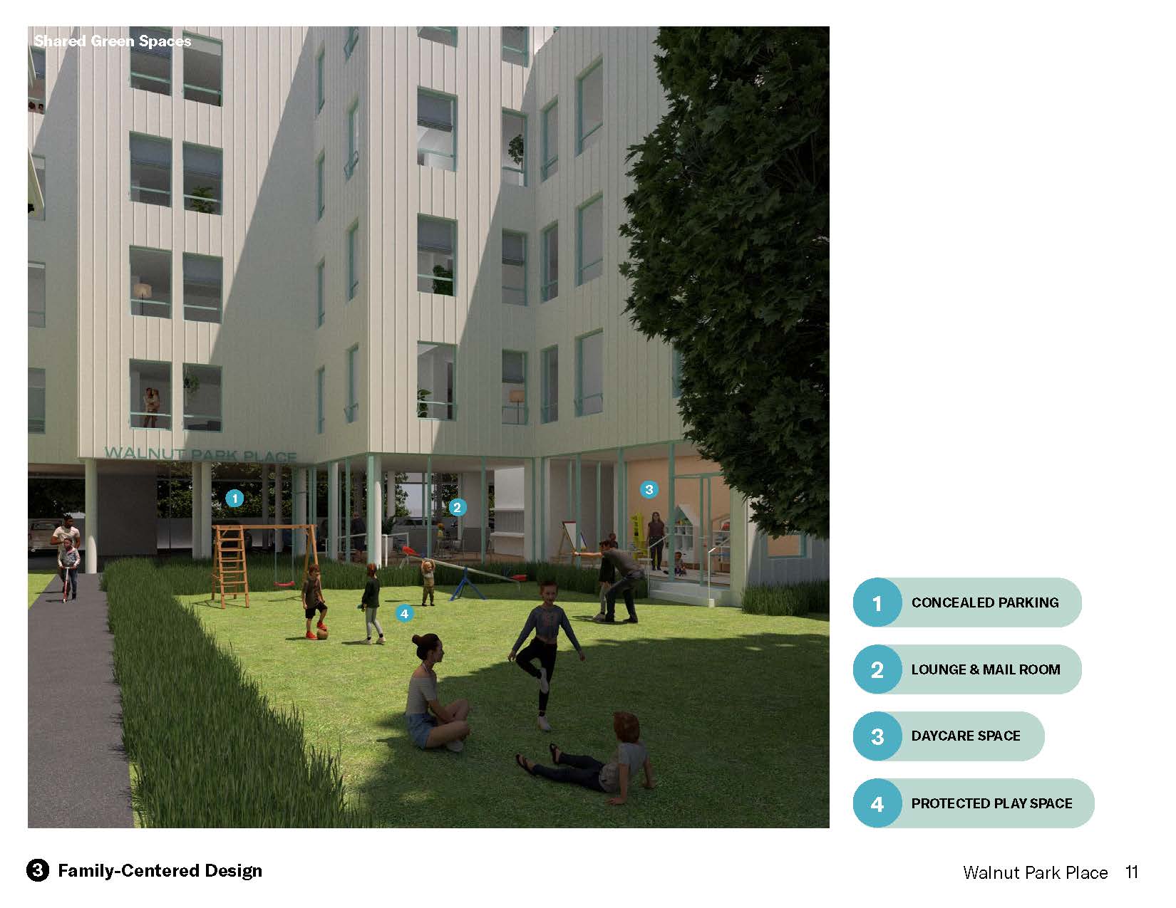
Aaron Smithson (MArch/MUP ’25), Cat Chen (MArch ’25), and Maggie Weese (MUP/MPH ’24)
Walnut Park Place is a 29-unit affordable homeownership development in the Egleston Square area of Roxbury. Designed with sensitivity to both its physical context and the stated needs and desires of local residents, the project leverages both public sources and residential cross subsidy to provide middle-income Roxbury families with an increasingly rare opportunity to establish enduring roots in a fast-changing community. Walnut Park Place utilizes a family-centered design approach, incorporating a ground-floor daycare, a protected play space, larger units, and open-unit floor plans to better serve the needs of residents. The site’s “disguised density” approach strategically distributes the project’s massing to increase affordable ownership opportunities in Roxbury while ensuring the project remains contextual.
Connecting Gilman Square: A New Housing and Green Space Development
Connecting Gilman Square: A New Housing and Green Space Development
Chandler Caserta (MArch I ’25), Austin Sun (MLA/MArch I ’24), Kei Takanami (MArch I ’25), and Amber Zeng (MArch I ’25)
This project proposes a 196,020 sq ft transit-oriented mixed-use building and public park in Somerville, Massachusetts. Given the current limited amount of open green space in Somerville, Connecting Gilman Square envisions a revitalized identity for Gilman Square through a new public landscape and building. It aims to create a community identity around a new transit station by introducing market rate and affordable housing, a public outdoor park, a grocery store, cafes, restaurants, artist workshops, and non-profit offices on two underutilized lots adjacent to the new Gilman Square Station.
We will introduce 150 new units of housing with 20% at affordable rates (50%, 80%, and 110% AMI). This project aligns with Somerville’s Somervision 2040 plan to increase housing and stimulate the commercial sector in Somerville. By configuring the housing block to a L-shaped stack on the southwest corner of the site, the building is able to shield the public park from railway disturbances. This project targets young professionals in the Somerville area through a mix of studio and two-bedroom units. The building opens its corner to the Somerville Community Path to give generous access to outdoor activities for both residents and park-users alike. Through the transit-oriented development, the revitalized site becomes a gateway connecting this public green space to the greater Boston area.
The strategy to pair a housing project with a public park considers both the financial viability and social benefits for Somerville and the Greater Boston area. Using a capital stack of equity and grants to support the new green space and infrastructure, Connecting Gilman Square will transform this previously underutilized industrial site into new transit-oriented housing and a publicly accessible landscape.
Monterrey’s Urban [River] Forest: Improving Microclimatic Conditions through Public-Private Partnership Vertical Development
Monterrey’s Urban [River] Forest: Improving Microclimatic Conditions through Public-Private Partnership Vertical Development
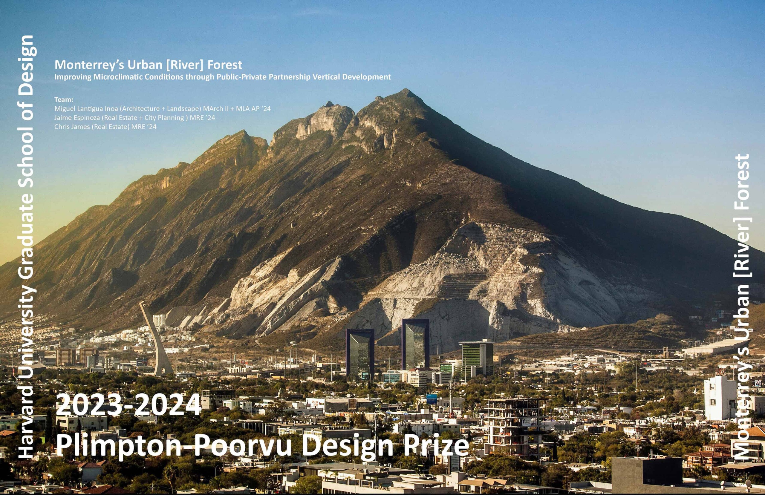
Miguel Lantigua Inoa (MArch II/MLA AP ’24), Jaime Espinoza (MRE ’25), and Chris James (MRE ’25)
Design Challenge-Opportunity
Monterrey, Mexico, a desert metropolis nestled against the backdrop of the Sierra Madre Oriental mountain range, has experienced rapid urban development in recent decades. This development, however, has unfolded within a complex socioeconomic and environmental context that poses unique challenges to the city’s sustainable growth. Monterrey’s economy, powered by a strong industrial base, has attracted a diverse workforce, leading to significant urban sprawl. Yet, this economic prosperity has not been evenly distributed, contributing to stark socioeconomic disparities. The city grapples with issues of affordable housing, where a booming population and rising real estate prices have pushed lower-income families into cramped and poorly serviced neighborhoods, exacerbating social inequities.
Response to Climatic Vulnerabilities and Open Space Needs
The environmental challenges facing Monterrey, particularly those related to climate change, are equally pressing. Water scarcity has emerged as a critical concern, exacerbated by the city’s semi-arid climate and extreme weather events, such as droughts and floods. These climatic vulnerabilities have underscored the need for sustainable urban planning practices that prioritize water conservation and innovative management solutions. Moreover, the rapid pace of Monterrey’s urban development has led to a reduction of open spaces, further straining the city’s ecological balance. The lack of open spaces not only impacts residents’ quality of life but also diminishes the city’s ability to mitigate air pollution, regulate temperatures, and provide recreational spaces for its inhabitants.
Harness Financing for More Sustainability and Inclusivity
In response to these challenges, the proposed development project in downtown Monterrey seeks to address these multifaceted issues by revitalizing the Santa Catarina River. This ambitious initiative aims to harness financing from the construction of mixed-income residential developments, thereby tackling the affordable housing crisis while simultaneously creating valuable public spaces. By integrating open spaces, the project aspires to foster a more sustainable and inclusive urban environment. This approach not only aligns with Monterrey’s socioeconomic needs but also sets a precedent for addressing urban development in harmony with environmental sustainability and social equity.
Catalyst for Broader Revitalization
Additionally, the proposed development along the Santa Catarina River is envisioned as a catalyst for the broader revitalization of Downtown Monterrey. By increasing the residential base with mixed-income housing, the project seeks to infuse the downtown area with a vibrant, diverse community, thereby enhancing its socio-economic fabric. This influx of residents is expected to further stimulate economic growth, attracting businesses, retail, and services that cater to a revitalized downtown core.
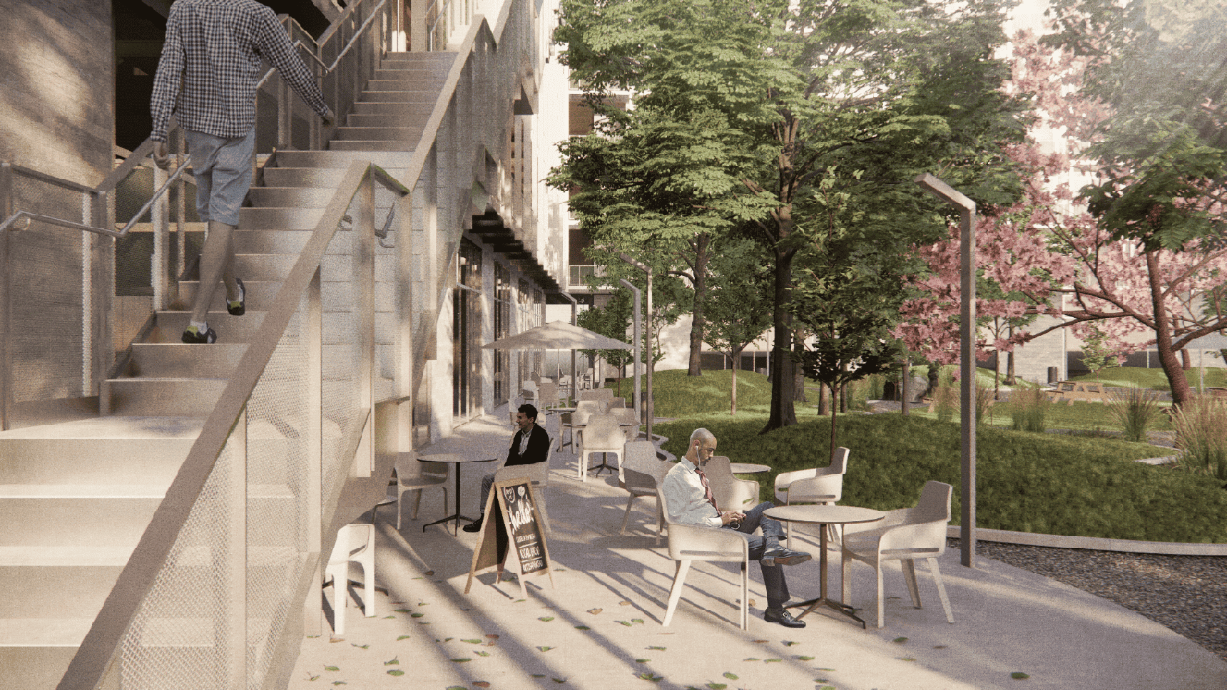
The Santa Catarina River
Rio Santa Caterina is a paradox for Monterrey. For a city with severe water scarcity, the river accommodates the episodic influx of water from several hurricanes which occur every 10-15 years. While the river hardly contains water, it is an essential infrastructure. In the process of the most recent storms, a robust ecological habitat has formed within the predominantly dry riverbed. It is within this dynamic condition that El Gran Río de Bosque (Urban River Forest) advocates for the importance of microclimatic environments which can combat Monterrey’s urgent heat and water crisis, create equitable cross-city access to a robust ecological habitat, and increase housing within the heart of the city. These three primary objectives are achieved through strategically leveraging the river’s ecology, its primarily low-density adjacencies, its increasingly flourishing habitats, and its potential east-west connectivity. In this way, the Rio Santa Caterina is an episodic urban forest in the river capable of setting the tone for how to work with water, enabling responsible developments, and expand the Urban Street Foresting of the city for climatic comfort.
Downtown Monterrey Context
With historical significance, political representation, and rich cultural heritage, Downtown Monterrey is a microcosm of the city’s identity. However, despite being the heart of Monterrey, the downtown area has faced a severe challenge – a significant decline in population density.
While Downtown Monterrey was once a bustling hub with over 100,000 residents, the population within the 1,000-hectare area has shrunk to a mere 23,000. This demographic shift over the last several decades has led to a significant degradation of the urban fabric.
In response to the severe decline of Downtown Monterrey, the local municipality has prioritized revitalizing the city’s core into one that may become a compact, dense, and sustainable urban model. Such revitalization efforts include plans for repopulation, environmental restoration, and a renewed sense of community. Indeed, these revitalization plans are informed by engagement with existing residents, ensuring their vision for the future reflects their collective aspirations.
To this end, the proposed project for Monterrey’s downtown draws inspiration from successful revitalization efforts in other North American cities. These initiatives demonstrate the power of public sector investment as a catalyst for broader development. The place-based strategy prioritizes public infrastructure upgrades, such as improved streetscapes, revitalization of underutilized open spaces, and investment in housing projects to foster a sense of community and address population decline. This multi-pronged approach aims to generate newfound demand for living and working in the downtown core, sparking a wave of community and economic development.
SILVERLINE: A New Model for Data Centers in the Age of AI: Verticalities at the Edge of the Cloud
SILVERLINE: A New Model for Data Centers in the Age of AI: Verticalities at the Edge of the Cloud
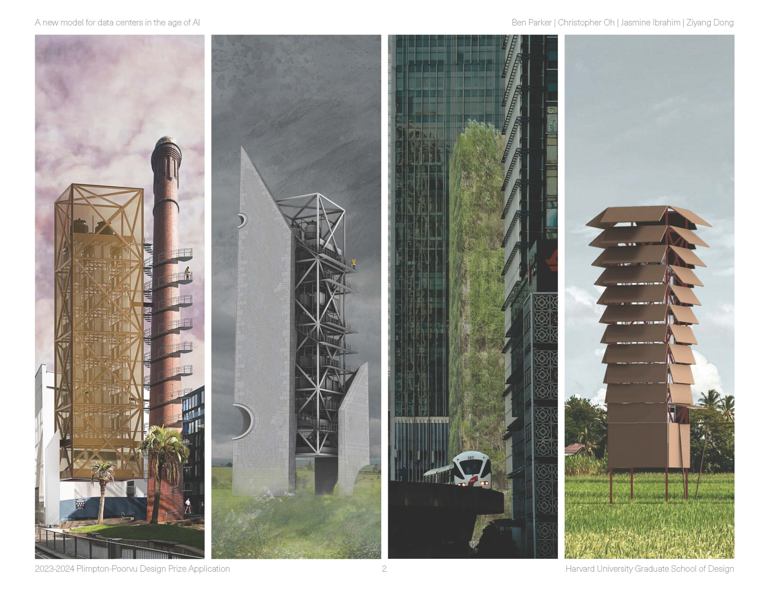
Ben Parker (MAUD ’24), Christopher Oh (MAUD ’24), Ziyang Dong (MArch ’25), and Jasmine Ibrahim (MRE ’25)
Data centers underlie all the most important technological developments of the past three decades, and emerging innovations like generative AI rely even more heavily on the remote storage and computing that data centers provide. Yet for all their transformative impact, data centers are remarkably conventional buildings. The typical model of data center development holds the same pitfalls and consequences of most construction: degraded water quality, habitat destruction, car dependence, failing power grids, unchecked sprawl, visual monotony, increasing wealth disparity, and accelerated climate change. This need not be the case.
Silverline: Positive Potential at the Edge of the Cloud
As a design-driven real estate startup, we bring to data center buildings all the transformative aspiration that technologists bring to the servers within it. We propose a new model of data center development that preserves land, minimizes fossil fuel emissions, respects cultural context, and invests in disadvantaged communities, all within an attractively profitable financial model made possible through a new product type.
Silverline Edge-Colo data centers are medium-sized, 8-28 megawatt data centers that support low latency applications. They utilize a series of technological innovations to bring increased energy efficiency and better price-to-performance compared to traditional data centers. Immersion cooling and robotic operations reduce MEP costs through minimizing building HVAC and lighting requirements, resulting in competitive construction costs and hyper efficient power use (PUE). A system of nested modularity creates economies of scale and connects into an integrated system that starts with the microchip. This uninterrupted modularity, from chip to server to rack to building, creates the possibility of streamlined procurement, cutting construction time to further save on cost. Finally, biomethane fuel cells replace diesel fuel as the power source for the data center’s backup generators, a significant sustainability improvement.
Silverline’s Thin, Vertical Typology Addresses Land Constraint Issues
The data center industry has made great strides in power use efficiency and renewable fuels but has yet to consider land as a sustainability issue. In contrast to the traditional, land-hungry approach, Silverline proposes a vertical model: each data center tower holds 4-24 levels of server racks with mechanical equipment above and below. In urban areas where land is expensive and parcels can be small or unusually shaped, this provides more flexibility to locate near customers. In rural areas, where agricultural and ecological land preservation is a core issue, a tower solution disturbs less land and can minimize regulatory hurdles regarding zoning changes.
Colo-Edge Data Centers: Digital Proximity is the New Industry Buzzword
The proliferation of low latent technologies involving AI has become a strong tailwind for building urban data centers. The benefits of locating close to the end consumers of data outweigh the construction premium, which is absorbed via higher rents charged to tenants. Investment grade cloud providers like Google and Amazon are willing to pay a premium to be closer to the end consumer and ensure high customer retention.
Blue Ocean Strategy: First Mover Advantage in a High Growth Market
Digital consumers and businesses are pushing data closer to end users, where industry research has noted higher growth rates compared to the established “hyperscale” in the mid-to-long term. Despite this demand for expanding edge infrastructure, cloud providers are deterred by the high barriers to entry in securing downtown land and seeking permitting approval for data center development from the local authorities in both urban and rural locations.
Bridging the Digital Divide with Decentralized Colo-Edge Data Centers
Access disparity between urban and rural internet users remains an important issue for digital infrastructure. As an incentive for local governments to lease land in dense urban cores for data center developments, Silverline will cross-subsidize data centers for underserved rural populations, allowing these communities to access high speed internet. Rural data centers also support 5G connection, an infrastructure upgrade that would increase demand density in rural areas to achieve competitive market rents in the near future.
Modular Core, Adaptive Shell: Contextualizing an Anonymous Box
Local public opposition has halted recent data center projects in Ireland, the US and other countries, with moratoriums on some data center construction in Singapore and the Netherlands. Such community concerns have the industry rethinking its traditional approach to data centers as large, anonymous, unidentifiable boxes. With each data tower, Silverline pairs a modular core with a contextually adaptive shell that incorporates aesthetic and ecological considerations. The core is identical in every project, while the shell is the product of local architectural competitions sponsored by Silverline. The core holds all of the technological components of the building, while the shell addresses outward considerations of structure, façade, circulation, and how the building meets the ground. This opens a dialog between infrastructure and design that could manage the tension between ubiquitous use of the cloud and a similarly ubiquitous opposition to its physical presence.
To test Silverline’s globally adaptable core + shell strategy, we will first develop Silverline in paired urban/rural locations in Ireland, a strong market with mature planning practices and significant sustainable power. We then envision a scenario in Malaysia, a leading growth market with starkly different environmental, cultural, and regulatory conditions. Silverline would then continue expanding globally as the product is tested and refined.
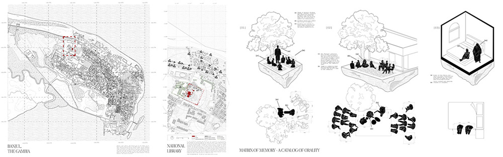
KEUR FÀTTALIKU — The House of Recollection
KEUR FÀTTALIKU — The House of Recollection
Mariama Muhammadou Modou Kah (MArch II ’24)
The Western canon valorizes its ability to define, critique, and comprehend itself through the lens of its recorded histories. Credence and legitimacy are assigned to the documents produced, with alters constructed to their study and exploration. For societies whose histories are retained in orality, a dynamic methodology of social memory transmittance and cultural production, such paradigms are limited and reductive.
Orality calls out to the architect for a space to be housed and edified. But how must this amorphous memory-keeping practice and the act of its recollection dwell?
Taking on the themes of memory and repair to envision the architecture of oral history, this thesis aims to challenge the notions around memory institutions, shed their status as static repositories, and conceive an architecture that establishes the intimacy of understanding the past and is the site for conceiving the why of the future, in the capital city of Banjul, The Gambia.
Place-Time: From Waste to 3D CAD, or, Framework for geographical and temporally conscious design
Place-Time: From Waste to 3D CAD, or, Framework for geographical and temporally conscious design
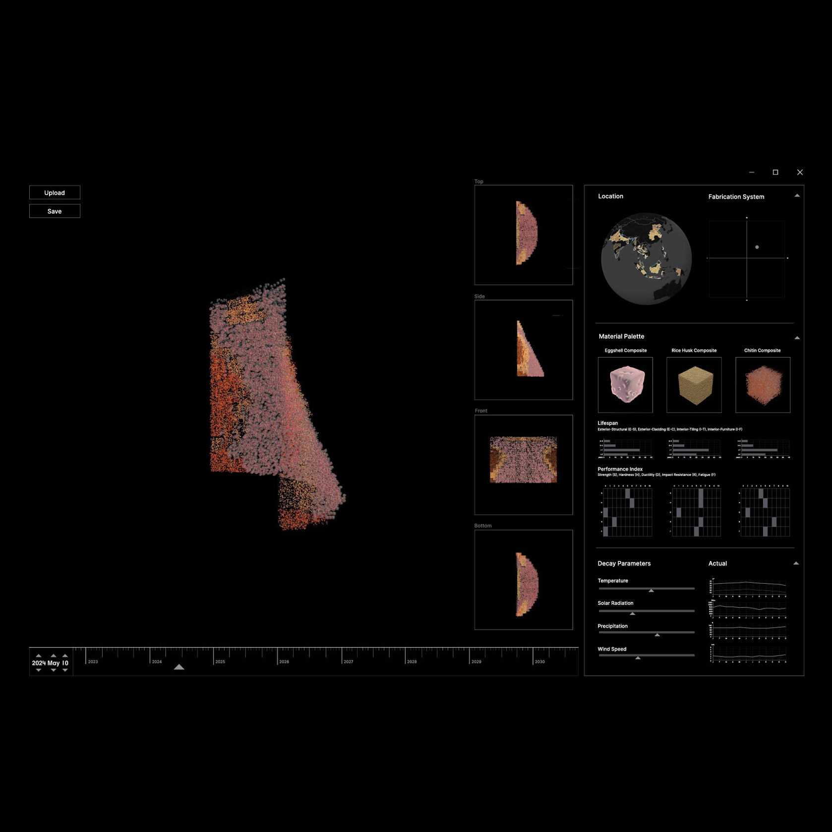
Amelia Gan (MDes ’23)
The dominance of digital design and computer aided design (CAD) tools in contemporary architectural practice has resulted in a predominantly form-first design approach, creating a disconnect between the idealized form and material realities. This method of selecting materials as an afterthought prioritizes materials that are homogeneous and stable, such as concrete and steel, as they are easily casted to fit a form. Consequently, local material availability and material lifecycles are not taken into account. and instead, sand, gravel and various metals are over-extracted. This necessitates a search for alternative sources of building materials that are cyclical such as bio-based materials. However, a transition to bio-based materials cannot simply replicate our current industrialized logic, as this would result in similar material depletion issues. Designing with bio-based materials entail consideration for the materials’ embedded temporality, dimension of localization, variation of mechanical properties, and impending decay.
This project seeks to bridge the gap between the two paradigms where form-dictates-matter and matter-dictates-form by proposing a 3D modeling tool that is location-based and time sensitive. The development of the tool is informed by material experimentations on commonly found agricultural waste in Southeast Asia, specifically eggshells, rice husk and crustacean shells. Based on the project geography, a location-specific material palette is generated. This is then used for digitally modeling the idealized form, where the environmental data (temperature, humidity, precipitation, and wind) is used to parameterize the decay of the form over time. By simulating future decay of specific materials in a design tool, Place-Time seeks to calibrate our understanding of time perception with environmental time.