Highlands’ Harvest
Highlands’ Harvest
Alysoun Wright (MUP/MLA I AP ’21)
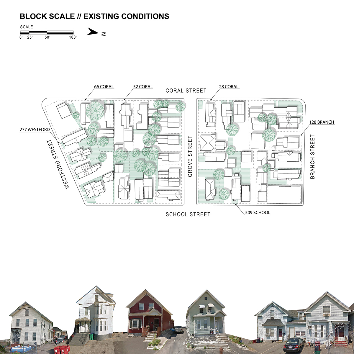
The Lower Highlands neighborhood of Lowell, MA consists predominately of residential blocks. Additionally, 30% of the neighborhood’s 74% impermeable surfaces are categorized as driveways and lots. Parking demand and considerations of maintenance in a high renter context often preference impermeable surfaces, thereby contributing to surface water runoff, water contamination, and urban heat island effect. In response, the Highlands’ Harvest pilot program seeks to increase permeable surface within the Lower Highlands Neighborhood by leveraging existing interests in gardening and food production and creatively making use of residual space within the dense urban fabric.
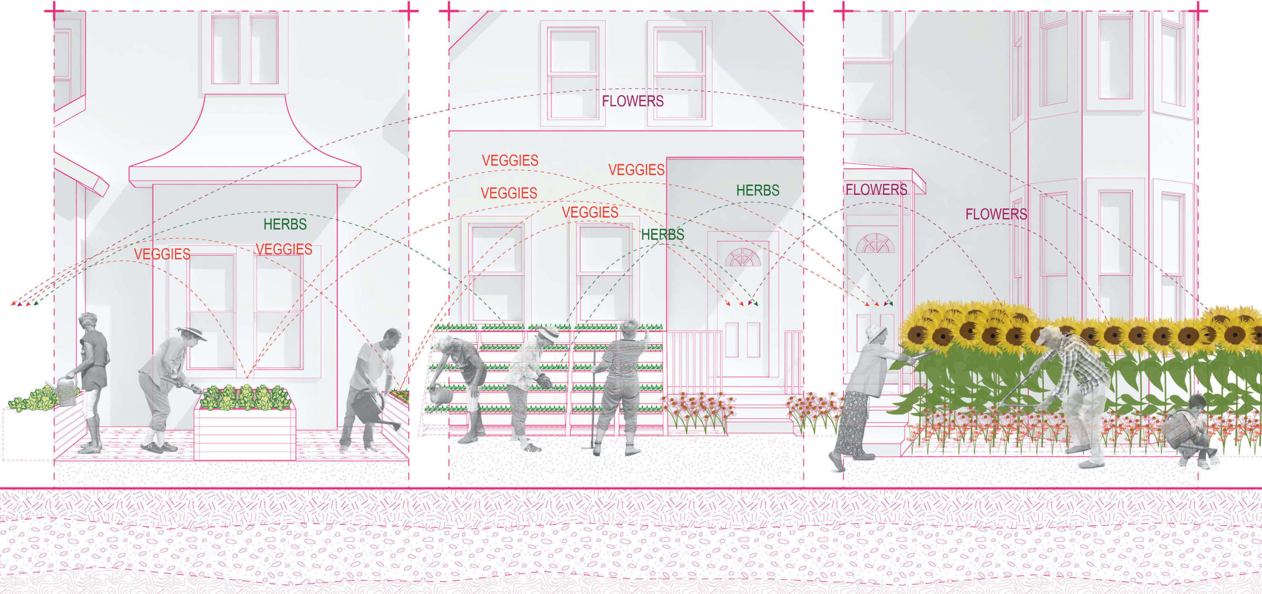
The Highlands’ Harvest Program is an optional program that is targeted towards residential blocks with less than 40% permeable area. As part of the program, homeowners self-identify impermeable portions of their parcel that are underutilized, or could perhaps function similarly with a more permeable surface covering. These spaces are then enrolled in a lease agreement with Highlands’ Harvest which pays a rental fee to the homeowner. The use and management of this space can then operate in several different scenarios, in which either a homeowner, renter, or Highlands Harvester would have the option to manage the space.
Full implementation of the Highlands’ Harvest program would result in the distribution of herb gardens, flower patches, and urban farming across residential blocks within the Lower Highlands. The harvest of these micro-sites would then be aggregated and redistributed as an ongoing CSA to block participants.
The objective of Highlands’ Harvest is to build upon the neighborhood’s existing strengths in order to move towards and incentivize the creation of a more permeable urban fabric. The hope is to demonstrate that such shifts can be productive, collaborative, and incremental. Furthermore, it is envisioned that through this process both owners and renters alike will feel greater connection to their community and urban fabric.
Meeting House: Using the Window as a Generator of Interstitial Space
Meeting House: Using the Window as a Generator of Interstitial Space
Sonya Falkovskaia (MArch I ’23)
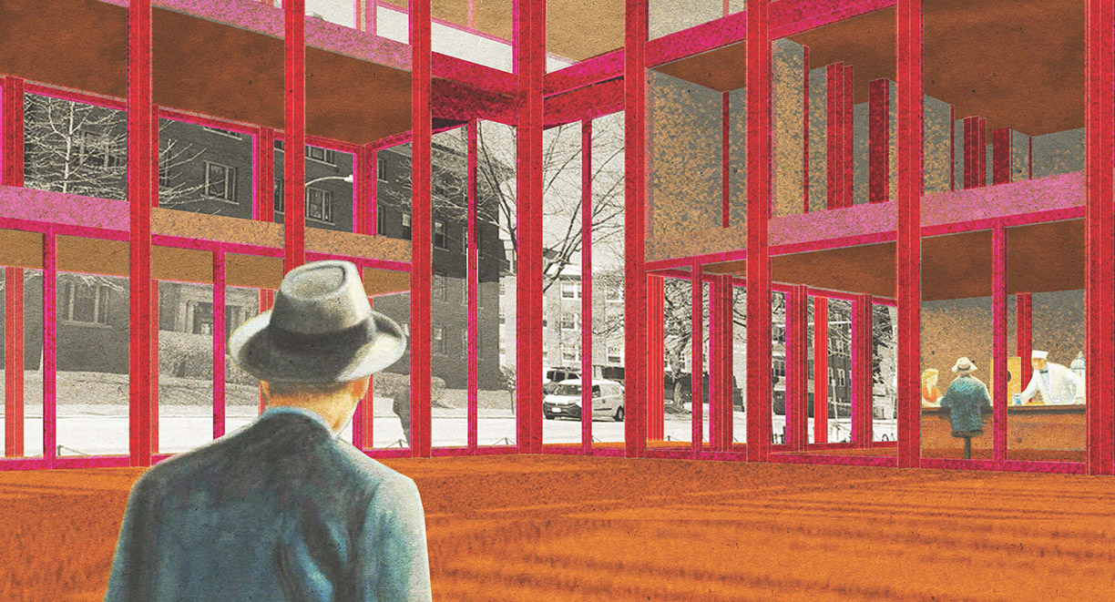
“Meeting House: Using the Window as a Generator of Interstitial Space” explores how a changing depth of facade can act as a mediator of varied interior environments. The window is our primary connection to the outside world when existing within buildings. This project experiments with what the window can come to represent and how it changes our engagement between internal and external space.
Much like the layers of a window, there is interstitial space that contributes to how we perceive these two fundamental elements. This building aims to take the principle of layers within a window and apply them to the building, turning the whole facade into one cohesive window mechanism.
The project proposes a clubhouse for the Harvard campus, consisting of three houses: a community house, a guest house, and a graduate house. The three houses are intertwined to produce one place where each of the three groups across Harvard’s campus can connect.
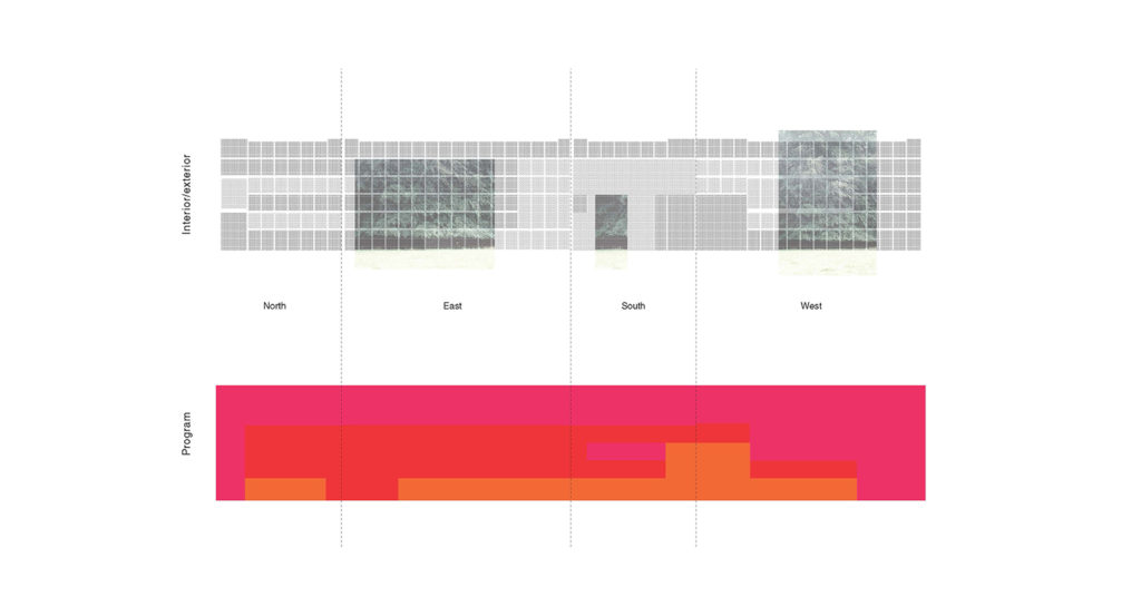
Within each house, there are three scales of room. The smallest module of the room is used to build the rest of the building. Each scale contains a fragment of the concept that gets compounded when reading the building as a whole. The building is created by an enveloping thick facade that wraps around to create a void within. The facade is folded both in plan and section. By using this folded surface, light and air are maximized.
Detroit’s Got Lots: The Generation Z Guide to Warrendale’s Vacant Lots
Detroit’s Got Lots: The Generation Z Guide to Warrendale’s Vacant Lots
Ann Salerno (MLA I ’18)
Warrendale—like many of Detroit’s neighborhoods—has a lot of vacant lots. Almost every street has empty houses and lots. With all of these lots, this neighborhood can be hard to love, and even harder to understand, because of how empty it feels. For refugees, this semi-suburban, empty feeling landscape is incredibly difficult to understand and feel a part of. For the local community, this state of vacancy can be demoralizing. This project aims to empower and give agency to teenagers—both refugees and locals—by leveraging those vacant spaces to create a sense of ownership of the neighborhood. Teenagers, or Generation Z, are part of all communities in Detroit. Their influence on trends, as well as their presence on social media and technological savvy, makes them perfect people to begin to imagine a different Warrendale.
This booklet is a guide to the vacant lots of Warrendale. It will try to make sense of how Warrendale came to look the way it does, and try to answer some of the main questions about vacant lots. How did they get there? Who owns them? Why haven’t they changed? How are they used today? Why do they look this way? Secondly, this booklet, along with the use of social media, will help illustrate potential futures of these lots and show how teens can help shape the future of these lots.
Street Dreams: Redefining Revitalization at West Warren Avenue
Street Dreams: Redefining Revitalization at West Warren Avenue
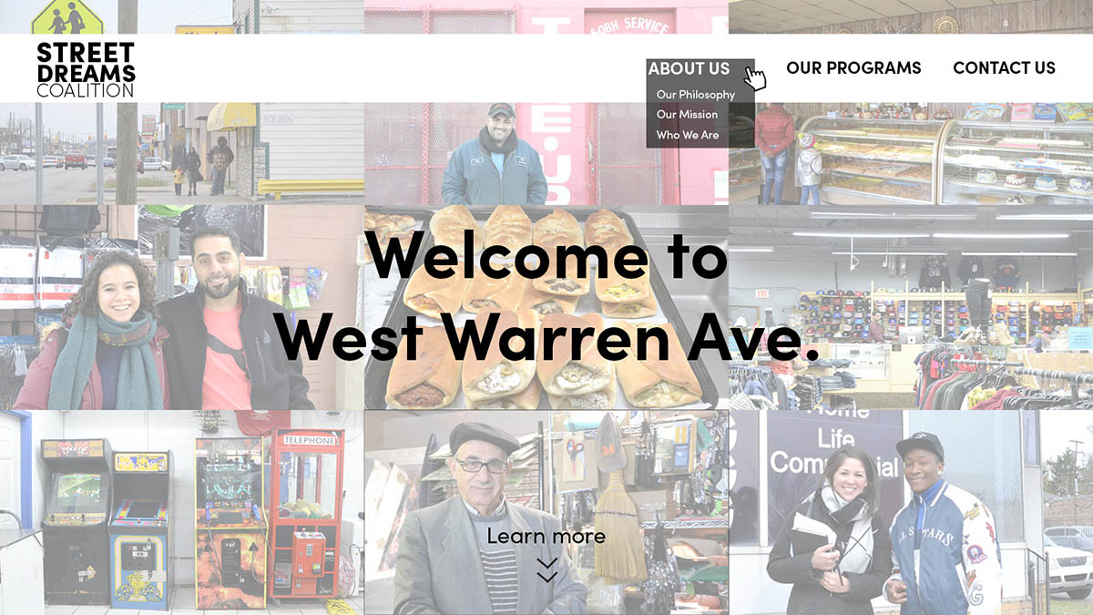
Natasha Hicks (MUP/MDes ’19) and Simone Hodgson (MUP ’18)
This project explored what inclusive commercial corridor revitalization might mean and look like for both the existing predominantly Black community and the incoming immigrant and refugee community in Warrendale, Detroit. After on the ground research and surveying locals it became clear that Warrendale is a very unique neighborhood, and yet is almost entirely invisible and unknown to other Detroiters. A thorough analysis of the current conditions on West Warren Ave. (Warrendale’s key commercial corridor) revealed some of the neighborhood’s strengths, but also uncovered the weaknesses at play: low levels of community capacity, underlying tensions around racial/ethnic stereotypes and inequities in business ownership, a near absence of community identity, and little outside investment.
By unearthing a street rich in history, with deeply-rooted challenges, and full of powerful stories, “Street Dreams: Redefining Revitalization at West Warren Ave.” contemplated how the prevalence of vacant commercial properties could be considered an opportunity to build community capacity, bring diverse groups together, and create a neighborhood identity in Warrendale. This project designs a vision for a new community organization called Street Dreams Coalition that takes elements from three different types of organizations—Community Development Corporations, Business Improvement Districts, and a Commercial Community Land Trusts—to create a new model for building community power and advocacy in Warrendale.
Growing-Up Warrendale: Trauma-Informed Landscape Operations for Neighborhood Intersections
Growing-Up Warrendale: Trauma-Informed Landscape Operations for Neighborhood Intersections
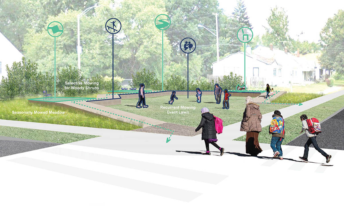
Ana Cristina Garcia (MLA I ’17)
The neighborhood of Warrendale in Detroit is transforming into a receiving community for an arriving Arab refugee and immigrant community. Although the receiving and arriving communities share little cultural or ethnic similarities, both communities have had to endure adverse and traumatic experiences. Trauma is defined by a prolonged exposure to toxic stress. Toxic stress is the body’s continued activation of physiological stress responses and, can be particularly damaging to children’s psychosocial well being. The point of departure of this project is the understanding that trauma, although stemming from different experiences in each community, has a shared neuro-developmental effect in children. This project focuses on the potential of the neighborhood to mediate the traumas of children in both the receiving and the arriving communities. The aim is to identify features in the neighborhood that trigger and contribute to a stress-response and transform them into places of physical and emotional safety for children.
Transmission Right of Way
Transmission Right of Way
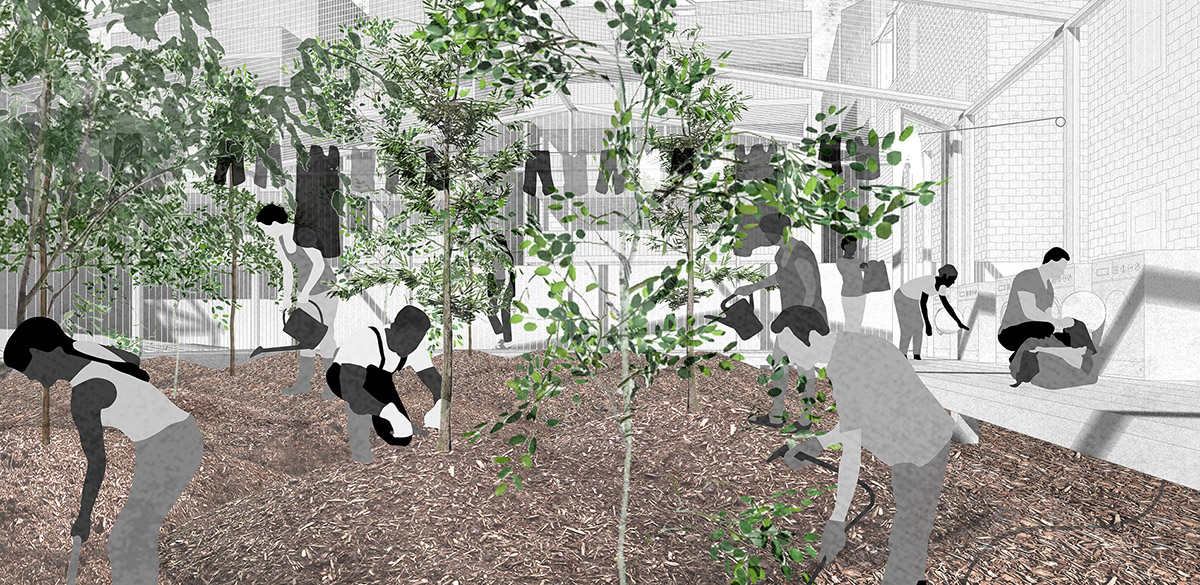
Fabiana Casale (MLA I AP ’22), Yvonne Fang (MLA I ’21), and Maria Ulloa (MLA I AP ’21)
Currently, energy production and consumption within the city is depleting the hinterlands. Despite attempts to adapt “sustainable” modes of energy, existing urban lifestyles continue to accelerate land degradation through resource extraction in the hinterlands. We acknowledge that our consumptive habits are shaped and exacerbated by forms of living in the city. As such, innovative urban spatial solutions are necessary for changing the way we dwell.
Situated in South Boston, “Transmission Right of Way” establishes a waste-to-resource conversion network that is facilitated by the ground and living systems. Our redefinition of transmission right of way as an ecological easement network first emerged through synthesizing hinterland reform policy and electric grid guidelines. This project establishes a new commons through an intra-urban network of collective land ownership that gives residents the agency to choose their level of investment.
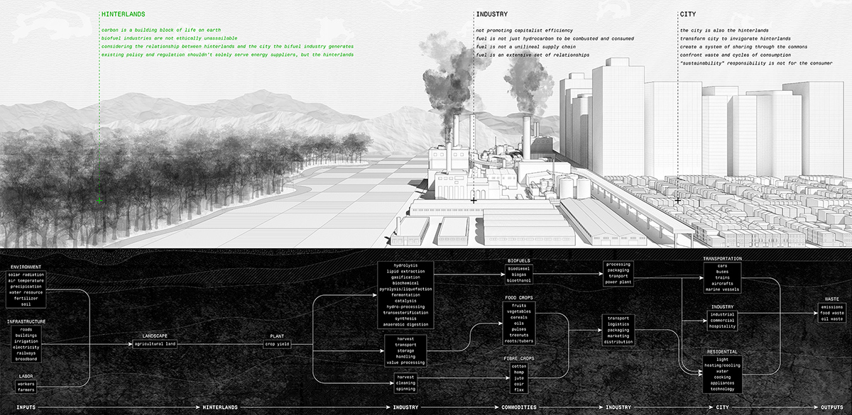
This new transmission right of way generates public power and resources, meaning that we are neither beholden to the power supplier monopoly nor are we profit-driven. Along with our design proposal, the project stipulates that residential and communal land-uses must make way for living energy infrastructure that ensures the community’s reliable resource and power supply as well as transmission.
In our speculation of the post-carbon city, we cast urban form as a mutualistic system driven by expanded notions of spatial caring. This care comes from close encounters with land and ecological processes, altered relationships to consumption, and collective labor that engenders a living commons. This expanded care enables a new way of living that renounces energy as unilineal consumption and instead embraces the notion of energy in which we become accountable for all direct and indirect labor, costs, and sacrifices that support our existence. All in all, “Transmission Right of Way” is founded upon frank accountability, tenacious democracy, sincere institutional support, and above all, conscious love and care for absolutely everything that enables us to live aspirationally.
Live/Work/Rent
Live/Work/Rent
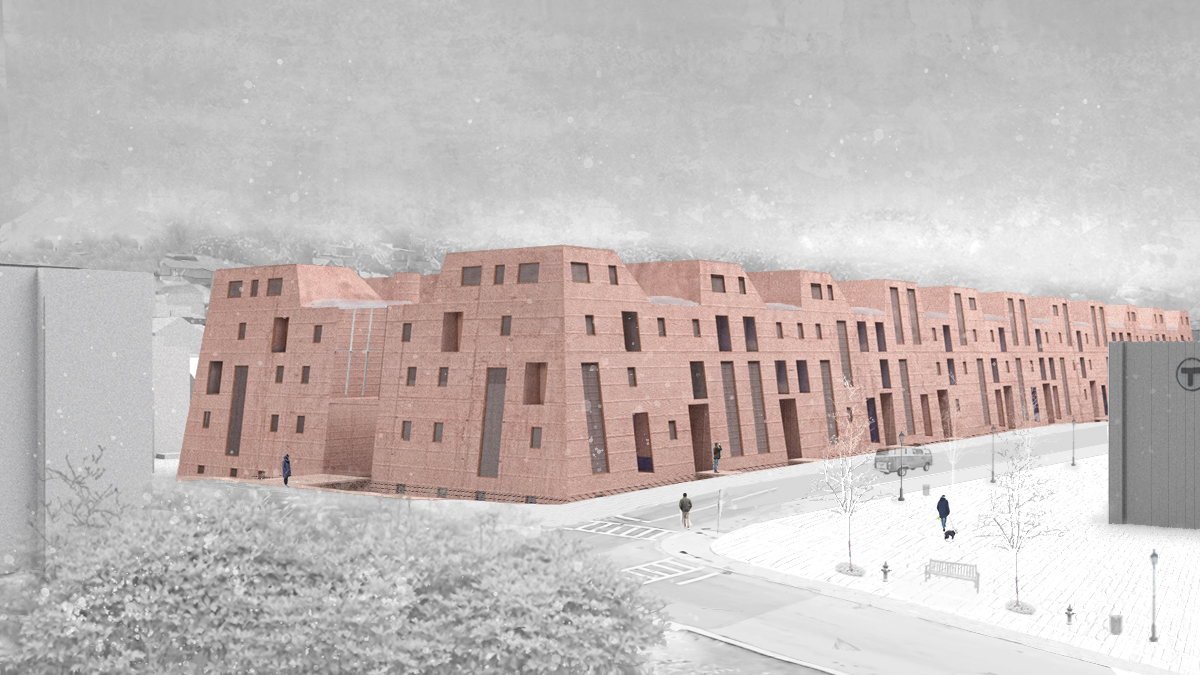
Tyler Rodgers (MArch I ’22) and Tracy Tang (MArch I ’22)
This project addresses the near future of collective housing for gig economy workers through the lens of a heightened housing shortage and the prevalence of self-employment in 2050. The proposal adapts the model of live/work cooperative housing to incorporate nested accessory dwelling units. The design enables residents to rent out part of their unit, challenging the normative conditions of residential spaces by allowing personal and industrial zones to overlap. We would like to propose a new condition of integrating remote gig working with a relatively stable lifestyle. We speculate that, in 2050, a group of gig workers would form a housing cooperative with a sustainable architectural environment for their 24-hour activities, including spaces for working, cottage-industry activities, small-scale production, and units that could be frequently rented out.
The form of the industrial deep plan is particularly appropriate for our site, which contains a mix of brick industrial and residential building types in close proximity. In addressing the condition of the site, we sought to combine signifiers of these two building types.
Based on precedent studies of the IBEB Cooperative Housing Project in Berlin and the Lacaton and Vassal Grand Park transformation, we established an initial critical area of focus on how to create a housing project that utilizes a deep plan, with integrated lightwells and community spaces for residents. These strategies of integrated light wells, community workspaces, and expanded interior streets, continued throughout the project.
Our second critical area of focus relates to the medium scale of our project: embedding a nested unit so the gig worker residents of our housing project can rent out part of their space and generate extra income. We began to study creating a thickened wall space within our project, where a nested accessory dwelling unit could exist. Nested towers of accessory dwelling units are situated between the primary units, ringing the lightwells of the deep plan. These nested towers form an additional community space at the medium scale of the project, and function as open spaces that provide light to the primary units ringed around them in the plan. The towers distinguish themselves from the primary apartments through a different interior materiality. While most of the building is conceived to be painted concrete, shown in white in this image, the towers inhabit a warm, wooden interior that is more intimate.
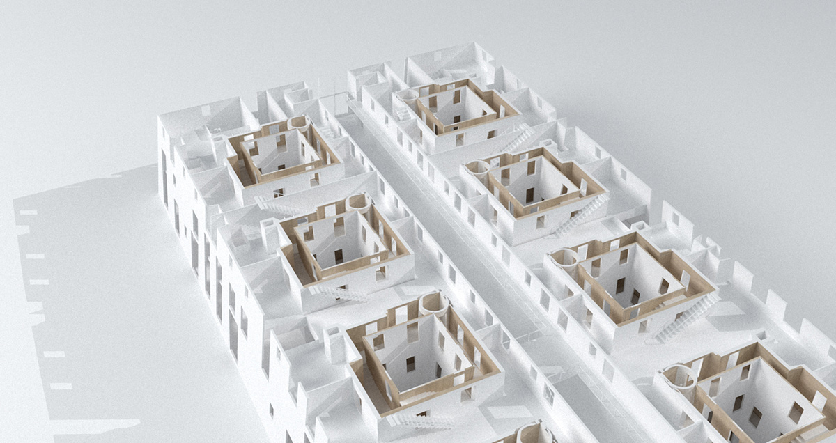
On the first floor, this variety of duplex units is arranged at the sides of the building touching the tower, so that each unit has access to a nested accessory unit. The first floor, as previously mentioned, has two conditions, a closed condition that separated communal workspaces, and an open market condition that connects these spaces into a continuous gathering hall. On the second and third floors, units are accessed from a large central communal street, and there are shared community spaces on the roof.
Within the project, there is a global relationship between the light well that brings light into the deep plan, the cozy nested accessory space, and the more spacious primary unit space.
Franklin Park’s Edge
Franklin Park’s Edge
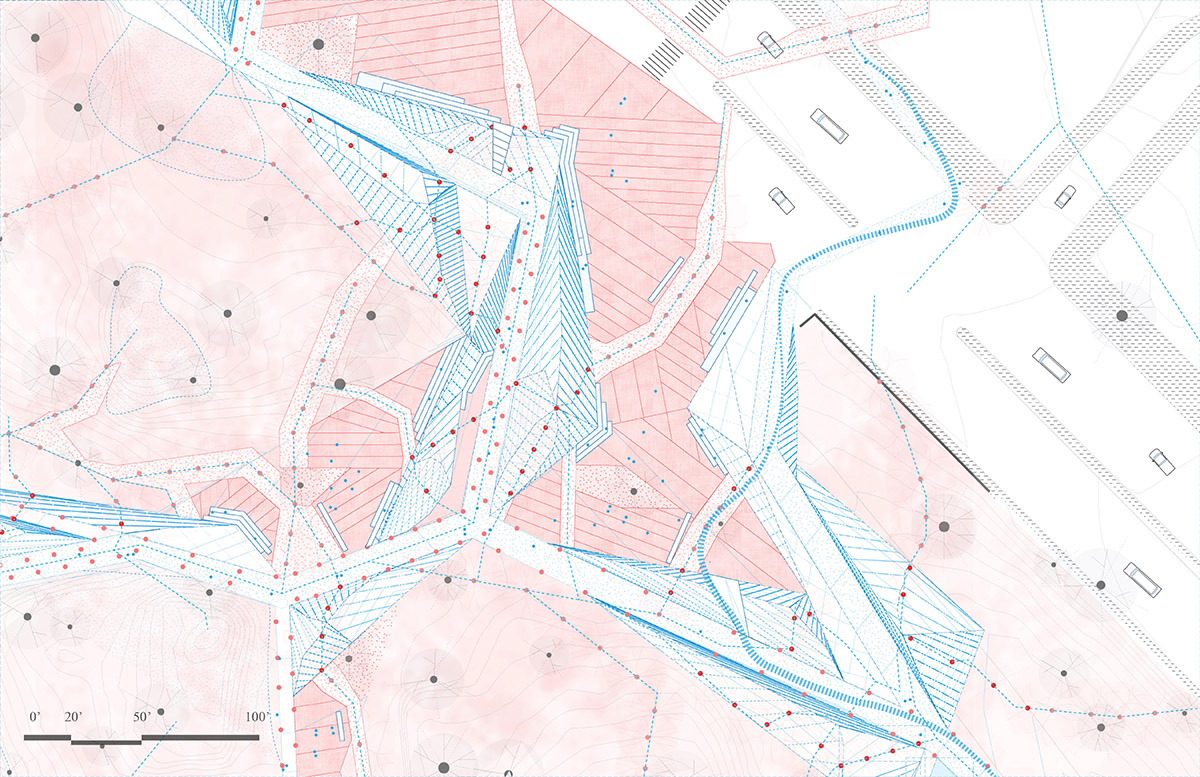
Sophie Mattinson (MLA I ’22)
In “Franklin Park’s Edge,” the perimeter opens to its surrounding neighborhoods by relaxing the current topography for accessible pathways connecting the city’s street level to the park. Cues indicating entry into Franklin Park can be read from the ground: curb cuts, material transitions, pavers, and paint markings. Before crossing Sever Street and heading towards the park in its current condition, thickets of trees and boulders enclosed by stone walls obscure the interior’s view. Occasionally visitors are welcomed by signage and crosswalks located as frequently as each residential block, but those traveling from the quieter corners must hug the stone wall along narrow sidewalks and fast-moving avenues until they reach an entrance.
The Littoral between Definite and Indefinite
The Littoral between Definite and Indefinite
Andrea Sandell (MArch I ’23)
The project focus lies in the littoral zone—the zone of exchange between the figure and the plane—and proposes to reinterpret an original diagrammatic entanglement as a calibrated choreography, whereby spaces are constructed through the tension between the explicit and implicit. The resultant exchange is carried throughout the building, suggesting a synthesis that occurs on and through floors.
A rectangular bar volume folds in at two corners through which the interior is accessed. Within, a tripartite ordering of set, figure, and set runs through every floor. While office spaces—the sets—flank the figures on either side, in the center, a series of public programs are arranged in a vertical gradient.
The boundaries established by the tripartite division are obfuscated by the choreographed interplay.
Granular spaces develop, yet orient themselves in relationship to the readability and glimpses of the boundary offices.
Figures spill towards the periphery, suggesting specificity within an otherwise uninflected plane.
The Ellipse
The Ellipse
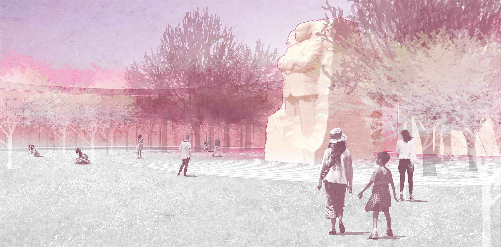
Xinyi Chen (MLA II ’21)
The National Mall in Washington, D.C. will be affected by sea level rise and high tides into the future. By 2100, the predicted flood level will be 18 feet above the low tide level today. Without any intervention, most of the area will be inundated by water, including the Martin Luther King, Jr. Memorial.
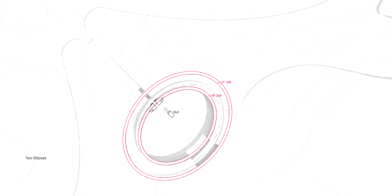
To act upon these conditions over the next 50 years, this project addresses climate change by raising the landform around the MLK Memorial up to 30 feet. The gradually spiraling upwards elliptical landform delivers to visitors a highly varied encounter that moves from monumental to more eye-level contact. Further, “The Ellipse” opens the relationship of Dr. King’s edifice to a commanding presence on the Tidal Basin, enlarging its impact and therefore its narrative potential.